- Alabama Counties - Alabama County Map, Counties in Alabama
- Major Cities - Birmingham, Mobile City, Montgomery
- Neighboring States - Tennessee, Georgia, Mississippi, Florida
- Regional Maps - Map of USA
- Other Alabama Maps - Alabama Map, Where is Alabama, Map of Alabama Cities, Alabama Physical Map, Alabama Lat Long Map, Alabama Zip Code Map, Alabama Area Code Map, Alabama National Parks Map
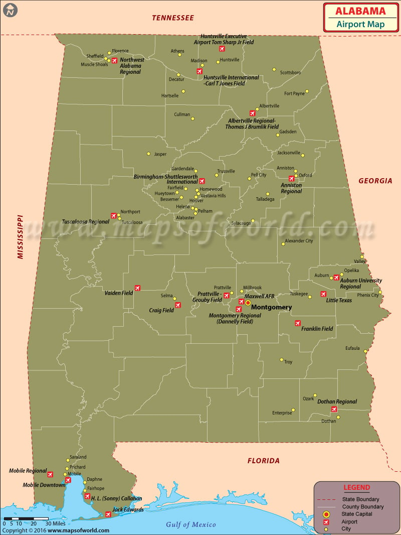
Birmingham-Shuttlesworth International Airport (BHM)
The biggest airport in Alabama is the Birmingham-Shuttlesworth International Airport. The airport serves Birmingham and Central Alabama. Flights are available to critical airports in bordering states and overseas locations. Flights are also available to cities like Mobile, Huntsville, and Montgomery. It is an integrated civil-military airport situated 5 miles northeast of Birmingham city center, close to the junction of I-59 and I-20. In 2009, Birmingham-Shuttlesworth International Airport served more than 2.9 million passengers. It ranks as the busiest and biggest airport in Alabama. Birmingham-Shuttlesworth International Airport currently operates 136 daily flights to 43 airports in 40 cities across the U.S.
The airport can manage all categories of airliners. There are two runways and one terminal building, which is split into two concourses. American Airlines, Delta Airlines, US Airways, and Southwest Airlines are some major airlines flying from the airport.
Huntsville International Airport (HSV)
Huntsville International Airport is situated 9 miles southwest of downtown Huntsville, Alabama. It serves the Huntsville-Decatur Combined Statistical Area. The address is 1000 Glenn Hearn Boulevard in Huntsville. The airport is famous for its simple design. It has 12 entrances and comes with restrooms, restaurants, shopping outlets, telephones, and big wall paintings. The Four Points by Sheraton Hotel is closely located. The airport’s western runway is the 2nd most extensive in the Southeast U.S. It is the biggest freight transport airport in the state. Important airlines operating from this airport include American Airlines, Delta Airlines, US Airways, and Vision Airlines.
Addison Municipal Airport
Addison Municipal Airport is a city-owned, public-use airport located one mile northeast of the central business district of Addison, in Winston County, Alabama, United States. The airport covers an area of 37 acres and comprises a single runway designated 4/22 with a 2,631 by 112 ft turf surface. Addison Municipal Airport had 1,416 general aviation aircraft operations for the 12 months that ended on 5 April 2000.
Maps of Major Airports in Alabama
- Birmingham Shuttlesworth International Airport Map
- Huntsville International Airport Map
- Addison Municipal Airport Map
List of Airports in Alabama |
|---|
| Airport Name | Code | City | Hub | Enplanements (2015) |
|---|---|---|---|---|
| Birmingham-Shuttlesworth International | BHM | Birmingham | S | 1,325,897 |
| Huntsville International-Carl T Jones Field | HSV | Huntsville | S | 519,785 |
| Mobile Regional | MOB | Mobile | N | 278,053 |
| Montgomery Regional (Dannelly Field) | MGM | Montgomery | N | 175,619 |
| Dothan Regional | DHN | Dothan | N | 46,792 |
| Mobile Downtown | BFM | Mobile | None | 2,410 |
| Tuscaloosa Regional | TCL | Tuscaloosa | None | 1,706 |
| Anniston Regional | ANB | Anniston | None | 1,598 |
| Northwest Alabama Regional | MSL | Muscle Shoals | None | 802 |
| Little Texas | 27AL | Tuskegee | None | 464 |
| Auburn University Regional | AUO | Auburn | None | 360 |
| Maxwell AFB | MXF | Montgomery | None | 293 |
| Jack Edwards | JKA | Gulf Shores | None | 55 |
| Vaiden Field | A08 | Marion | None | 30 |
| Huntsville Executive Airport Tom Sharp Jr Field | MDQ | Huntsville | None | 26 |
| Franklin Field | 07A | Union Springs | None | 20 |
| Prattville – Grouby Field | 1A9 | Prattville | None | 17 |
| H. L. (Sonny) Callahan | CQF | Fairhope | None | 3 |
| Albertville Regional-Thomas J Brumlik Field | 8A0 | Albertville | None | 2 |
| Craig Field | SEM | Selma | None | 2 |
 Wall Maps