So what’s the attraction? Crystal-clear water abounding in healthy coral reefs and marine life, for one thing. Vast flocks of seabirds in nesting season, spring and fall, for another.
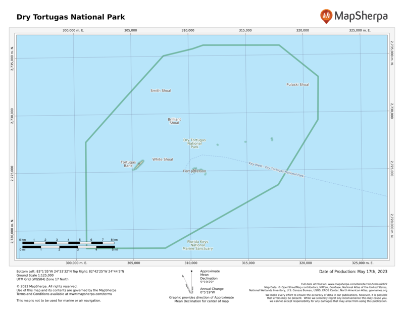
Most significant, though, is Fort Jefferson, the largest all-masonry fort in the United States. The 19thcentury fortification rises on one of the park’s tiny islands, Garden Key, and stands as an awe-inspiring example of sweeping military architecture. Its history is as unique as its glorious mid-water setting.
Tortugas is Spanish for “turtles.” Spanish explorer Juan Ponce de León came upon these specks of land in 1513 as he was sailing around Florida. He named them for the sea turtles found in the gulf. Sailors, including pirates, used the turtles as food and also took huge quantities of eggs from colonies of terns and other birds. The word “dry” was added to the name as a warning to sailors running low on freshwater that they would find none hereabouts.
The United States took control of the Dry Tortugas when it acquired Florida from Spain in 1822. A lighthouse was built on Garden Key, the largest of the islands, in 1825, to guide ships through the maze of reefs and shoals. (A taller lighthouse was constructed on nearby Loggerhead Key in 1858.) In 1846, the U.S. government began construction of a fort on Garden Key, intending it as a base from which to control ships trying to enter the Gulf of Mexico.
The fort was huge, with room for 1,500 soldiers and the capability to withstand a one-year siege. Construction continued through the Civil War until the U.S. Army abandoned the fort in 1874. Though some 16 million bricks had been assembled for its formidable walls, the fort was never officially finished. Despite its eight-foot-thick walls and sheer sweeping proportions, it had been made vulnerable by advances in artillery.
In addition, the structure had settled into the fine sand more than had been expected, and there were fears that adding more bricks and heavy cannons would cause the mammoth structure to sink.
Was all the effort wasted? Not really. Even though its cannons never fired a shot in conflict, its mere presence helped prevent foreign aggression.
During the Civil War and for nearly a decade after, Fort Jefferson served as a military prison. Its most famous prisoner was Dr. Samuel Mudd, who set the broken leg of John Wilkes Booth, the assassin of President Abraham Lincoln.
Although Mudd said he had no idea who Booth was when he performed the work, he was convicted of conspiracy and sent to the Dry Tortugas in 1865. Mudd was pardoned in 1869, in part because he had saved many lives during an epidemic of yellow fever at the fort in 1867.
Fort Jefferson was used sporadically for other purposes over the ensuing years, including as a refuge to protect nesting birds. In 1935 President Franklin D. Roosevelt declared Dry Tortugas a national monument, and the area was designated a national park 57 years later. Today the most enthusiastic visitors are history buffs, snorkelers, and bird-watchers.
How to Visit
Most visitors are day-trippers to main island Garden Key, on either a half-day or full-day seaplane trip or a full-day ferry trip. On a half-day trip (2.5 hours on the island) you have enough time for a quick tour of Fort Jefferson and a quick snorkel around the moat wall, although it might be more satisfying to choose one or the other.
On a longer visit, you can leisurely tour the fort, walking around the terreplein (the “roof”) and the surrounding moat wall. You can do some snorkeling and perhaps visit Bush Key (unless it’s off-limits because of bird nesting, in spring and fall).
If possible, consider an overnight at a very basic campsite (fee). You must bring all your supplies, including drinking water, to the site, but the solitude and chance to fully explore Garden Key offer a fine reward for the effort.
Useful Information
How to get there
Unless you have your own boat, transportation to Garden Key is by concession-operated seaplane (keywest seaplanecharters.com; 305- 293-9300) or ferry from Key West (drytortugas.com; 800-634-0939). Private charter boats can be booked in Key West.
When to go
The park can be visited year-round. Nov. through April can see cooler temperatures and rough seas with poor visibility for snorkeling and diving. May through Oct. brings calmer water and hot weather. Hurricanes, though rare, can strike June through Nov.
Visitor Centers
There is a small visitor center within Fort Jefferson. Information is also available at the Florida Keys Eco-Discovery Center (floridakeys.noaa.gov; 305-809- 4750), where a national park ranger is sometimes on duty.
Headquarters
P.O. Box 6208 Key West, FL 33041 nps.gov/drto 305-242-7700
Camping
Primitive camping (10 sites) is allowed on the small beach at Garden Key. The site has grills, picnic tables, and toilets. Campers must be completely self-sufficient; water, food, shower facilities, and supplies are not available at the park. Note that all trash must be packed out.
Lodging
There is no lodging in the park other than the campground sites. Lodging of all sorts is plentiful in Key West (keywestchamber.org; 305-294-2587)
US National Parks Map
About the Guide


