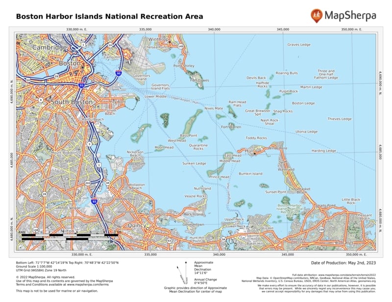
Boston Harbor Islands National Recreation Area is situated in Boston Harbor in Boston, Massachusetts. It is one of the most sought after attractions for hikers and travellers.
This recreation area offers you a wide range of attractions, including beaches, hiking trails, the oldest lighthouse in the US, Little Brewster Island’s Boston Light, and Georges Island’s Civil War-era Fort Warren.
Located within the Greater Boston shoreline, the Boston Harbor Islands National Recreation Area is spread across 34 islands, offering natural and cultural resources. Whether hiking the lush trails, gazing at stars while camping, picnicking, fishing, exploring tide pools, or swimming, this relatively small national recreation area offers everything for everyone.
Where is Boston Harbor Islands National Recreation Area
Boston Harbor Islands National Recreation Area is located in the Boston Harbor of Boston in the Commonwealth of Massachusetts. It is spread across 34 islands within the Greater Boston shoreline. Check this Massachusetts National Parks Map to find Boston Harbor Islands National Recreation Area on the Massachusetts Map.
Places to Visit Nearby
There are many attractions near Boston Harbor Islands National Recreation Area, including:
- Nearby Parks
- Boston African American National Historic Site
- Boston National Historical Park
- John Fitzgerald Kennedy National Historic Site
- Other Nearby Places
- World’s End
- Adams National Historic Park
- Nantasket Beach
- John F. Kennedy Presidential Museum & Library
- HaborWalk
- Fort Andrews
- Castle Island
- Edward M. Kennedy Institute for The United States Senate
- Gondola di Venezia
The closest cities and towns to Boston Harbor Islands National Recreation Area are:
- Hull
- Hingham
- Weymouth
- Quincy
- Winthrop
- Columbia Point – Boston
- Braintree, and many more
Things to Do in Boston Harbor Islands National Recreation Area
- Beaching
- Camping
- Hiking and Walking
- Touring
- Wildlife Viewing
- Lighthouse Tours
- Outdoor Activities for Families and Kids
- Junior Rangers Program
- Picnicking
- Swimming
- Ranger Guided Programs
- Kite-Flying
- Short Educational Film
- Visitor Centre Exhibits
Boston Harbor Islands National Recreation Area Hikes
Boston Harbor Islands National Recreation Area has 13 miles (21 km) of trails for hiking and walking trails to enjoy.
Best Hiking Trails in Boston Harbor Islands National Recreation Area
-
World’s End Trail
This 1.3 miles (2.1 km) long loop trail in Hingham (MA) is best for a great family outing. World’s End Trail encircles a small hill forming the park’s northern half. It is easy to hike a trail that enables you to walk through wide tree-lined paths having easy inclines and descents.
-
Deer Island Trail
Deer Island Trail is a 2.7 miles (4.35 km) long loop trail near Boston (MA) that will take you more than one hour to complete your hike. This easy trail offers you stunning views of the nearby islands, ocean, and Winthrop, a popular area for bird watching, walking, hiking, and trail running.
-
Planters Hill Loop Trail
It is an easy-to-hike point-to-point trail. Planters Hill Loop Trail is an easy to hike a trail that offers plenty of open space. This trail will take you less than 15 minutes to complete.
-
Spectacle Island Perimeter Trail
Spectacle Island Perimeter Trail is a 1.9 miles (3.06 km) long loop trail near Massachusetts’ Boston. It will take around an hour to complete this easy to hike the trail. April-October is the best time to visit this trail. This popular trail is best for walking, running, and hiking.
-
Brewer Road Trail
It is a wide tree-lined carriage point to point trail along Hingham Harbor’s shore. There is plenty of open space and also has an easy path. Brewer Road Trail has come up as a preferred destination for a family outing, wildlife viewing, birding, and enjoying fall colours.
List of Trails for hiking in Boston Harbor Islands National Recreation Area:
- World’s End
- Deer Island Trail
- Planters Hill Loop
- Brewer Road
- Barnes Road
- Webb Memorial State Park Loop Trail
- Spectacle Island Outer Loop
- North Drumlin Path
- Rocky Neck
- Weir River Road
- South Drumlin Path
Boston Harbor Islands National Recreation Area Facts
- The Boston Harbor Islands National Recreation Area is spread across 1,482 acres (2.32 sq mi or 6 sq km).
- It was established as a national recreation area on November 12, 1996.
- More than half a million people visit Boston Harbor Islands National and State Park every year.
Best Time To Visit Boston Harbor Islands National Recreation Area
The best time to visit the Boston Harbor Islands National Recreation Area is from mid-May to mid-October.
Visiting Hours of Boston Harbor Islands National Recreation Area
Boston Harbor Islands National Recreation Area remains open throughout the year from Sunday to Saturday, except for winter (mid-October to May).
Visitor Centre Visiting Hours:
-
Boston Harbor Islands Welcome Center:
Remains closed during the winter season (mid-October to May).
-
Georges Island Visitor Center:
Remains closed during the winter season (mid-October to May).
-
Spectacle Island Visitor Center:
Remains closed during the winter season (mid-October to May).
-
Peddocks Island Visitor Center:
Remains closed during the winter season (mid-October to May).
Boston Harbor Islands National Recreation Area Tickets Price
Boston Harbor Islands National Recreation Area doesn’t charge any admission fee. However, for using a public ferry, transportation fees are applicable.
US National Parks Map

