What are the Key Facts of Nevada?

|
State |
Nevada |
|
State Capital |
Carson City |
|
Largest City |
Las Vegas |
|
Coordinates |
39°N 117°W |
|
Nickname(s) |
“The Silver State (official)”, “Sagebrush State, “Battle Born State” |
|
Postal Abbreviation |
NV |
|
Area |
110,577 sq. mi (286,382 sq. km) |
|
Highest Point |
Boundary Peak, 13,147 ft (4,007.1 m) |
|
Number of Counties |
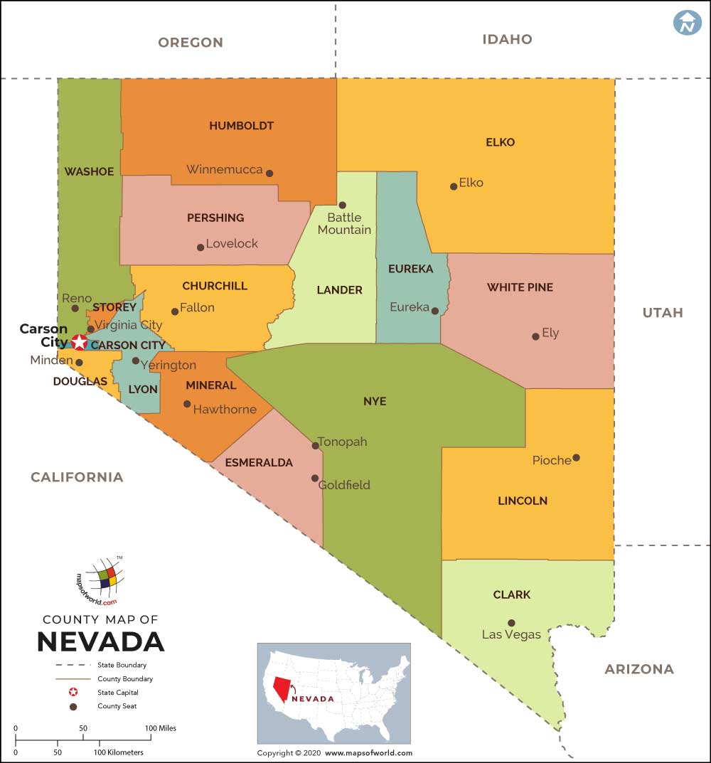
16 Counties and 1 Independent City |
|
Neighboring States |
Oregon, Idaho, California, Arizona, Utah |
|
Population |
3,034,392 (2018) |
|
Date of Entering the Union |
October 31, 1864 |
|
State Anthem |
“Home Means Nevada” |
|
Governor |
Steve Sisolak (Democratic Party) |
|
Lieutenant Governor |
Kate Marshall (Democratic Party) |
|
U.S. Senators |
Catherine Cortez Masto (Democratic Party), Jacky Rosen (Democratic Party) |
|
U.S. House Delegation |
Dina Titus (Democratic Party), Mark Amodei (Republican), Susie Lee (Democratic Party), Steven Horsford (Democratic Party) |
|
GDP (Millions of Dollars) |
169310 |
|
Demonym |
Nevadan |
|
Time Zones |
most of state UTC-08:00 (Pacific), Summer (DST) UTC-07:00 (PDT); West Wendover UTC-07:00 (Mountain), Summer (DST) UTC-06:00 (MDT) |
Where is Nevada?
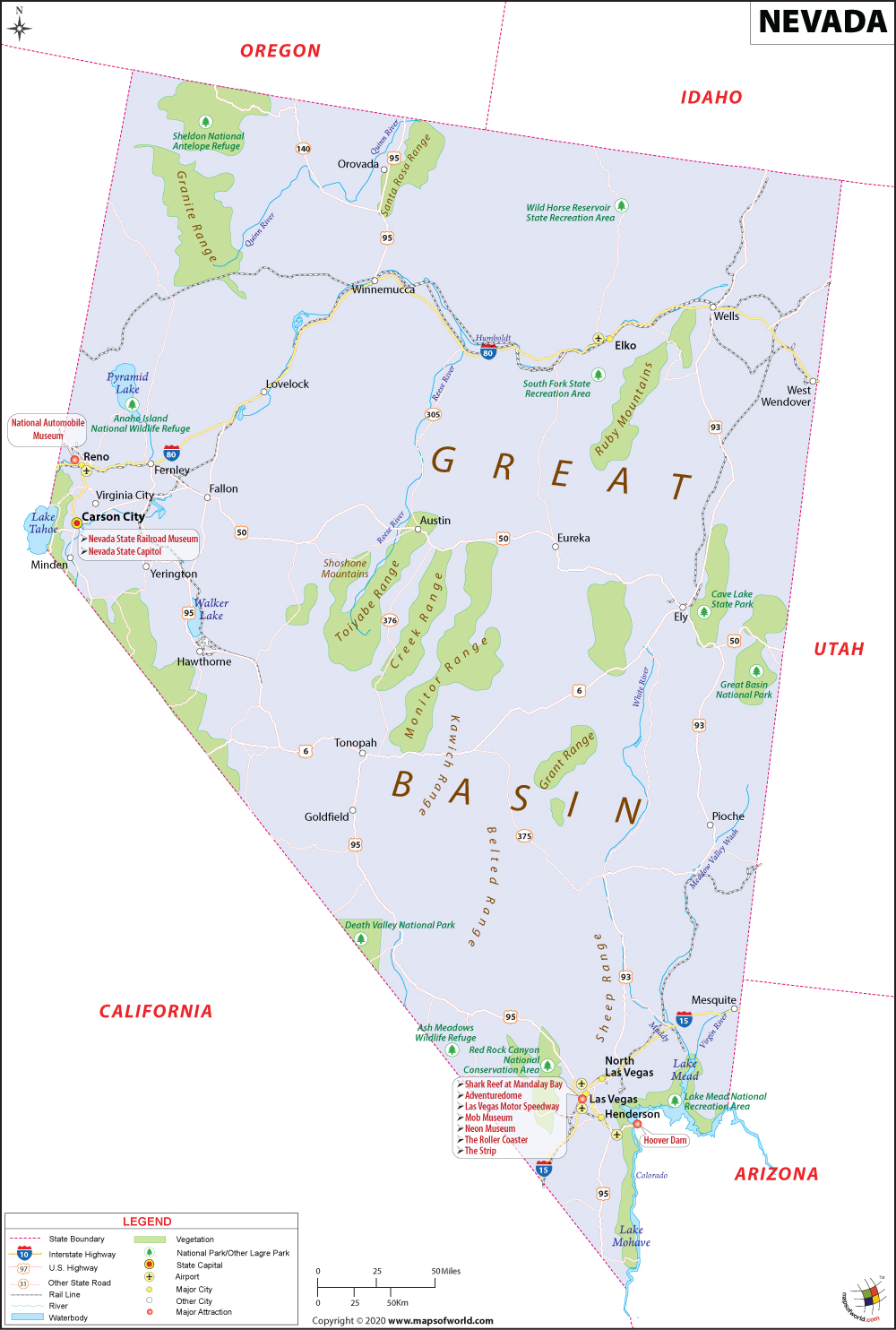
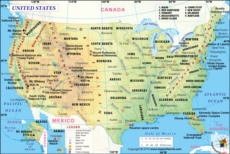
Nevada (the 36th state admitted to the union on October 31, 1864) is located in the western USA, almost entirely within the Great Basin. It shares its border with Utah to the east, Arizona to the southeast, California to the west, Idaho to the northeast, Oregon to the northwest.
What is the Geography of Nevada?
Nevada is spread across a total area of 110,577 sq. mi (286,382 sq. km), making it the seventh-largest state among 50 US states. The land is spread across 109,781.18 sq. mi (284,332 sq. km), the water area is spread across 791 sq. mi (2,048 sq. km). The state is around 490 miles (788.6 km) long and 320 miles (515 km) wide.
Water bodies are spread across a total of around 0.7% of the total area. The longest rivers in Nevada are Colorado River, Owyhee River, Humboldt River, Amargosa River, Reese River, Virgin River, Bruneau River, White River, Carson River, and Salmon Falls Creek.
The major lakes in the state are Lake Mead, Lake Tahoe, Pyramid Lake, Walker Lake, Lake Mohave, Ruby Lake, Rye Patch Reservoir, Lahontan Reservoir, Washoe Lake, Wild Horse Reservoir, Topaz Lake, South Fork Reservoir, and Adams-McGill Reservoir.
Nevada’s mean elevation is 5,500 ft (1676.4) above sea level. Boundary Peak is the highest elevation point in Nevada at 13,140 ft (4,005.1 m) above sea level, and the Colorado River at the southern end of Nevada is the lowest elevation point at 479 ft (146 m) above sea level.
The highest peaks in Nevada are Boundary Peak (White Mountains), Wheeler Peak and Mount Moriah (Snake Range), Mount Jefferson (Toquima Range), Charleston Peak (Mount Charleston in Spring Range), North Schell Peak (Schell Creek Range), Arc Dome, Bunker Hill, and Toiyabe Dom (Toiyabe Range), Currant Mountain (White Pine Range), and Ruby Dome (Ruby Mountains).
The landscape in Nevada is characterized by sandy deserts, grassy valleys, forested mountain slopes, and snowcapped, rugged mountains. There are three main regions in the landform, and they are the Columbia Plateau region, the Sierra Nevada region, and the Basin & Range Region.
The Columbia Plateau is located in the northeast corner of Nevada. Lava bedrock supports the land in this region. Deep canyons having steep ridges are found, which are formed when the bedrock is cut deep by the rivers and streams. Within the Columbia Plateau, an open prairie landform is located near the Idaho border.
The second most important landform is the Sierra Nevada. It consists of a rugged mountain range, cutting across the Carson City’s Nevada south. The beautiful glacial lake named Lake Tahoe is located in one of the valleys in this landform on the border between Nevada and California.
The third most important landform in Nevada is the Basin and Range Region. Over 150 mountain ranges can be found in this region, and all of them run from north to south. The Sierra Nevada landform is located to the west of the Basin and Range Region. Toiyabe and Toquima mountain ranges are situated in the center of Nevada. The Snake and Toana mountain ranges are located in the east. Single lone hills (known as buttes), flat-topped mountains (known as mesas), and flat valleys with lakes are scattered between the mountain ranges.
Many geysers and hot springs (which are remnants of dying volcanoes) can be found in abundance in Nevada.
What is the Climate of Nevada?
Nevada climate is characterized by arid to semi-arid types, which comes with cold winters and hot summers. It is the driest state out of the 50 US states. The dry climatic condition is influenced by the desert regions as well as the Pacific Ocean.
The arid nature of the climate is mainly because of the prevalence of desert land, of the Great Basin’s semi-arid regions, and rugged, high mountain ranges. The southern part of the state gets less rain, mainly because of the flat terrain.
The average rainfall level is just seven inches or 177.8 mm. Most of the rainfall takes place in Sierra Nevada’s leeward side. While north gets average precipitation of 12 inches (304.8 mm), the south receives only five inches (127mm). Heavy snowfall generally takes place in the north (around 20 inches or 508 mm) and the south (about 20 inches or 508 mm).
The summer months are severely hot and dry in this state. The day and night temperature difference usually exceed 40 °F (4.4 °C). During June-September, the day temperature goes above 100 °F (37.8 °C). Sometimes, it even reaches 120 °F (48.9 °C). While the northern parts get long and cold winter, the southern part gets short and mild winter. At the peak of winter in Las Vegas, the average daytime high temperature remains comfortably above 57 °F (13.9 °C) and the lows at night revolves around 38 °F (3.3 °C).
While the temperature remains warm during spring, the climate remains pleasant during autumn (or fall). In the plains, the minimum temperature stays within 15-20 °F (-9.4 °C to -6.7 °C). Temperature below freezing point (0 °F or -17.8 °C) usually remains just for a few days.
The months from March-May and September-November are the best time to visit Nevada.
What is the Economy of Nevada?
The economy of Nevada is dependent upon tourism (mostly related to entertainment and gambling of Las Vegas), mining, cattle ranching, printing and publishing, machinery, electric equipment, and food processing.
The total Gross Domestic Product (GDP) for Nevada increased from US$129,372.4 million in 2008 to US$169,309.9 million in 2018. The Per Capita Personal Income has increased from US$38,734 to US$49,176 during 2008-18. The Median Household Income in Nevada dropped from US$54,744 in 2008 to US$47,043 in 2011. However, it recovered to US$61,864 in 2018.
In 2018, the value of exports and imports were US$11,094,266,256 and US$11,793,165,953 respectively, resulting in a negative balance of -US$698,899,697. Nevada’s ranking in terms of exports, imports, and trade balance out of the 50 US states are 32, 33, and 15, respectively.
The principal exports are Precious Stones and Metals, Electrical Machinery, Toys & Sports Equipment, Ores, Industrial Machinery, Precision Instruments, Aircraft, Pharmaceuticals, Plastics, and Coffee & Spices. The principal imports of Nevada are Electrical Machinery, Industrial Machinery, Toys, and Sports Equipment, Precious Stones and Metals, Non-Knit Apparel, Aircraft, Precision Instruments, Furniture, Plastics, and Beverages.
The rate of unemployment was just 3.9% in January 2006. It started rising steeply since April 2007 when it was hovering around 4.2%. It peaked at 13.7% in October 2010. Since then, it had come down to 4% in November 2019.
Around 13% of the population in 2018 lived below the poverty line, which means 384,120 out of the total population of 954,279 was poor in Nevada. However, what is most alarming in Nevada is the racial, economic disparity. It is one of the top-10 US states having the most significant economic disparities. While just 10.3% of the white population is poor, an alarming 27.6% of African Americans and 23.9% of the Native Americans are considered ‘poor.’
What is the Transportation System of Nevada?
Nevada’s transportation is powered by important railroads and a vast range of roadways. Union Pacific’s original transcontinental railroad line is used by Amtrak’s California Zephyr train as daily service from Chicago to Emeryville (California), thereby serving Nevada’s Reno, Winnemucca, and Elko.
Commuters can use Amtrak Thruway Motorcoaches for traveling from Las Vegas and Stateline to different parts of California. While Union Pacific Railroad is an important railroad for Nevada’s north and south, Greyhound Lines are popular statewide bus services.
Some of the leading US routes passing through Nevada include US 95, US 93, US 50, US 6, and US 395. Except for a portion of Interstate 215, the Nevada Department of Transportation maintains all the active mainline Interstates. Some of the longest main interstate highways are I 80, I 15, I 580, I 11, I 515, and I-215. The major state highways in Nevada are SR 318, SR 140, SR 291, SR 225, SR 376, SR 375, SR 305, and SR 278.
The major airports in Nevada are McCarran International Airport (in Las Vegas), Reno/Tahoe International Airport (in Reno), Boulder City Municipal Airport (in Boulder City), North Las Vegas Airport (in North Las Vegas), Elko Regional Airport (in Elko), and Henderson Executive Airport (in Henderson, Las Vegas).
Why is Nevada called the “The Silver State?”
Nevada’s most well-known nickname is the “Silver State.” The origin of its name dates back to the mid-1800s when Nevada became the center of attraction of the silver-rush days. Silver was so abundant (dense gray crusts were formed on the desert surface for over millions of years) that the silver miners were able to shovel them off the ground literally.
The other popular nicknames of Nevada are “The Sagebrush State,” “The Battle Born State,” “The Mining State,” “The Sage-hen State.”
What are the Popular Tourist Attractions in Nevada?
Las Vegas (the Sin City), Hoover Dam, Lake Tahoe, Lake Mead National Recreation Area, Valley of Fire State Park, Red Rock Canyon National Conservation Area, Reno, Great Basin National Park, Burning Man, and Lamoille Canyon, to name a few.
Facts About Nevada
1) The official nickname of the state of Nevada is the “Silver State”. It is also known in other nicknames such as the “Sagebrush State” and “Battle Born State”.
2) The capital city of Nevada is Carson City and the largest city is Las Vegas.
3) Nevada shares its boundaries with Idaho, Oregon, Arizona, Utah, Lake Tahoe, California, and Hoover Dam.
4) Famous natives of this state include Andre Agassi, Lute Pease, and Thelma Nixon.
5) Las Vegas features the highest volume of shrimp consumption in the United States – over 60,000 pounds every day.
6) The city of Las Vegas features more hotel accommodations than any other city in the world. If you wish to spend one night in each of the hotel rooms in Las Vegas, you will need 288 years.
7) The official fossil is the Ichthyosaur.
8) The Kangaroo Rat, a creature inhabiting the Death Valley, has the ability to survive its whole lifespan by not drinking a single drop of fluid.
9) The Golden Gate Hotel and Casino is the oldest hotel and casino in the city of Las Vegas.
10) The state covers a total area of 110,562 sq miles, which makes it the seventh largest state in the United States.
11) The Nevada Gambling Museum is situated in Virginia City.
12) Nevada mines the biggest volume of gold in the United States and the state ranks second in the world after South Africa.
13) The state of NV was admitted to the Union on October 31, 1864 and became the 36th state of the country.
14) The official motto is “All for Our Country”.
15) The official bird is the “Mountain Bluebird”.
16) The official animal is the Desert Bighorn Sheep.
17) The state anthem is “Home Means Nevada”. The lyricist of the song is Bertha Rafetto.
18) At an elevation of 13,147 feet, the Boundary Peak is the highest point in the state of NV.
19) The official trees are the Bristlecone Pine and Single-Leaf Pinyon Pine.
20) The official fish is the Lahontan Cutthroat Trout.


![]()