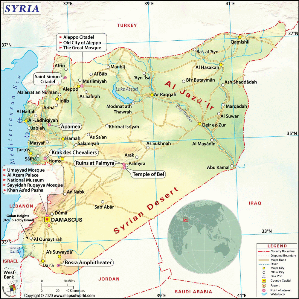
Syria Map
- Turkey Syria Earthquake 2023 - Turkey Map, Syria Turkey Map, Syria Lat Long, Turkey Lat Long, Syria Political Map, Turkey Political Map, Idlib Map, Gaziantep Map, Turkey 2011 Earthquake, Fault Line Map
- Syria Provinces - Al Hasakah, Ar Raqqah, As Suwayda, Aleppo, Damascus , Daraa, Deir ez-Zor, Hama, Homs, Idlib, Latakia, Quneitra, Rif Dimashq, Tartus
- Neighboring Countries - Lebanon, Iraq, Jordan, Israel
- Continent And Regions - Asia Map
- Other Syria Maps - Where is Syria, Syria Blank Map, Syria Road Map, Syria Rail Map, Syria River Map, Syria Cities Map, Syria Political Map, Syria Physical Map, Syria Flag
Explore Map of Syria : The Syrian Arab Republic is located in Western Asia. It shares its borders with Lebanon and Mediterranean Sea to the west, Turkey to the north, Iraq to the east, Jordon to the south, and Israel to the southwest. Its geographic coordinates are 32 38N, 35 43E.
History of Syria
Evidence of civilizations shows that Syria had settlements as early as 10,000 BC. In fact, the region was one of the centers of the Neolithic culture, where proof of cattle breeding and agriculture were first practiced in the world.
Syria is also home to one the earliest recorded civilizations, which was the Kingdom of Elba, established in 3500 BC. During the latter half of the 24th century BC, the region became part of the Akkadian empire.
By 539 BC, Persia took the region, but the conquest ended in 332 BC, after which it was taken by the Seleucid Empire, making Antioch its capital in 312 BC.
In 64 BC, Pompey the Great – a Roman emperor – conquered the region, and made Syria a Roman province.
During the 1st century, from 634 – 640, the Muslim Arabs conquered the land, including it in the Islamic empire. Damascus was established as capital in the mid-7th century.
Several other empires ruled Syria over the years, including parts of the region made into Crusader states in the 12th and 13th centuries, as well as the Mongol empire that captured some of the land in 1260.
The Ottomans arrived in 1516 and ruled Syria until 1918. In October of that year, Arab troops, which were led by Emir Feisal, captured Damascus. By March 1920, Feisal was proclaimed king but was forced to flee abroad in June of that same year after the San Remo Conference declared Syria and Lebanon to be under the French mandate.
National uprisings started to occur in 1925, eventually leading to Syria’s independence from the French in April of 1946.
Geography
Syria is located in Western Asia or the Middle East, and bordered by Turkey to the north, Jordan to the south, Israel to the southwest, Iraq to the east, and Lebanon and the Mediterranean to the west.
It is a land of fertile plains, deserts, and high mountains. The climate is hot and dry but due to its high elevation, winter season experiences occasional snowfall.
The northeast regions of Syria, which are the Al Jazira and the South Hawran, are important agricultural areas.
Polities
Syria is a semi-presidential republic with its President acting as Head of State and the Prime Minister as Head of Government. The legislative branch of government, called the People’s Council, handles passing laws, debating policy, and approving government appropriations. The Executive branch consists of the President, 2 Vice Presidents, the Prime Minister, and the Council of Ministers or the Cabinet.
The constitution requires that the President must be a Muslim but does not proclaim Islam as the state religion.
Travel
As home to several civilizations and empires of the past centuries, Syria is rich with historical monuments and ruins. Among these is the Palmyra, which is considered to be the most famous ruin city of all of Syria. A UNESCO World Heritage Site, Palmyra is an ancient Roman city located in an oasis. Among the popular sites are the well-preserved Roman theater, the huge temple of Ba’al, the Valley of the Tombs, and many arches and Roman columns.
The Dead Cities or the Forgotten Cities are a group of abandoned settlements that date back to the 1st to 7th century. Over 700 settlements or 40 villages can be found, which used to form the capital of Antioch. Countless ruins of dwellings, temples, churches, and bathhouses are found scattered all over the villages.
Salamieh, another ancient city, was established in 3500 BC. Today, well-preserved ruins are still found, such as Greek temple of Zeus, the Old Hammam, the Old Walls, and the remains of Roman canals.
Education
Education is free and compulsory in Syria for children ages 6 to 12. Primary education consists of 6 years, which is followed by a 3-year general or vocational training period, and another 3 years of academic or vocational education, with the latter required for university admission.
The entire education system in Syria has been closely governed by the Ba’ath socialist party since 1967. There are currently 6 state universities and 15 private universities, with top 2 state universities being the University of Damascus and the University of Aleppo.
Interesting Facts and Trivia:
- The capital city of Damascus is one of the oldest cities in the world.
- In public places, men and women are not allowed to talk to each other unless closely related. Cafes and restaurants have separate areas for men, as well as for women.
- 90% of the Syrian population are Muslim, mostly Sunni, and 10% Christian.
- According to ancient legend, mankind’s 1st murder occurred in Syria, when biblical Cain killed his own brother out of jealousy.
- The two stars in the Syrian Flag represent the previous union between Syria and Egypt.
- Lake Assad, which is the largest lake in Syria, is a manmade lake. More interesting facts about Syria