- Somalia Cities - Hargeisa, Mogadishu
- Somalia Regions - Ayl, Banaadir, Borama, Bosaso, Burao, Gedo, Hiiraan, Kismayo, Marka, Puntland, Somaliland
- Neighboring Countries - Kenya, Ethiopia, Djibouti
- Continent And Regions - Africa Map
- Other Somalia Maps - Somalia Map, Where is Somalia, Somalia Blank Map, Somalia Road Map, Somalia River Map, Somalia Physical Map, Somalia Flag
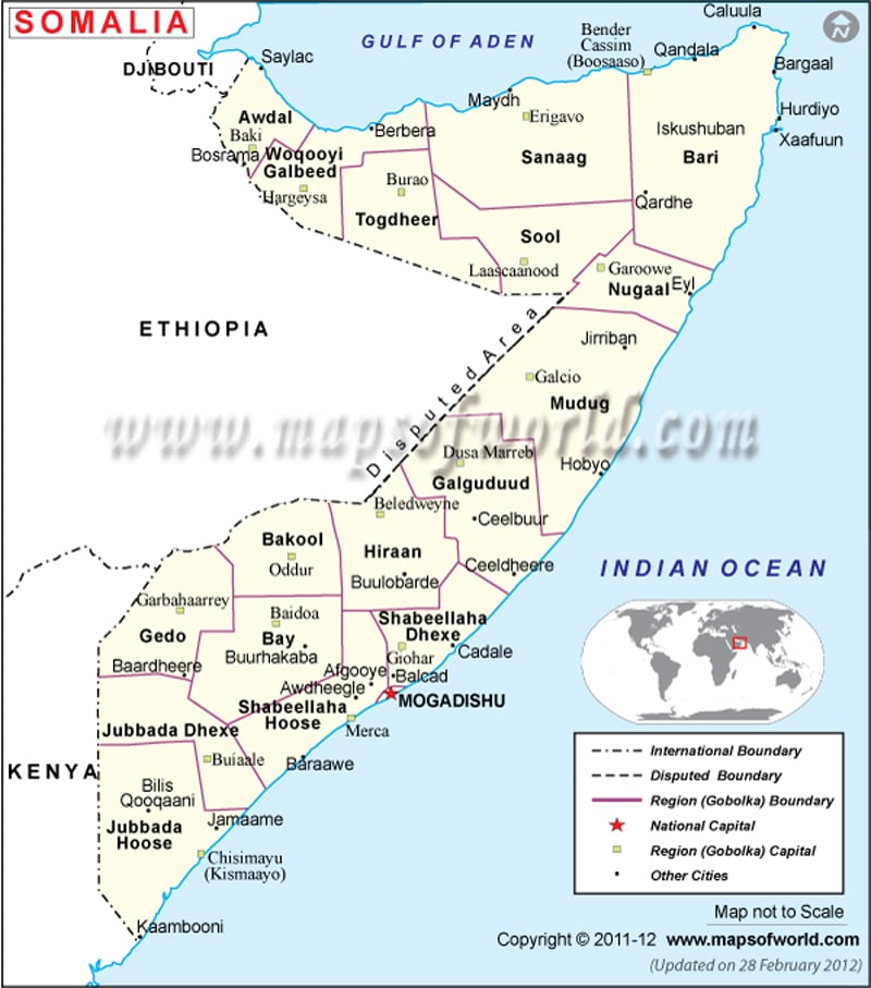
Somalia political map can be referred to know about the country’s Gobolka boundaries and their capitals.The Somalia Africa map also marks the capital of the country with a red dot and black dots signify major cities. The green squares on the map represent the capitals of the Gobolka boundaries.
Somalia political map is a visual representation of the regional boundaries, which constitute the country of Somalia. The map features Gobolka capitals, major cities and the capital of the country. Somalia is located in the eastern part of the African continent. It shares its borders with Gulf of Eden and Indian Ocean as shown in the map of Somalia Africa. Mogadishu is the capital of Somalia.
Location and Geography of Somalia
The Somalia Africa map also shows the location of the country. According to the map, Somalia is situated in the eastern part of the African continent. The country borders with Gulf of Eden and Indian Ocean. The geographical coordinates of the country are 10° North latitude and 49° East longitude. Somalia stands on a total area of 637,657 square kilometers. The area covered by land is 627,337 square kilometers and the area covered by water bodies is 10,320 square kilometers. The coastline of the country stretches over an area of 3,025 kilometers. Indian Ocean is the lowest point of Somalia and the highest point is Shimbiris, situated 2,416 meters above sea level.
Capital of Somalia
The capital of Somalia is Mogadishu and is situated at an altitude of 28 meters. It is marked with a red dot on the online map of Somalia. The latitudinal and longitudinal extent of the city is 2° 4′ North and 45° 22′ East longitude respectively. The neighboring cities are El Uerega, Garas Balley, Colomat, Caddey and Dabandoob.
Gobola Provinces and Capitals
The green squares on the printable map of Somalia represent the Gobola capitals or the regional capitals. They are listed below:
|
|
Important Cities
The major Somalian cities are marked with black dots on the printable map of Somalia. Some of the cities are Bilis Qooqaani, Jamaame, Baraawe, Awdheegle, Balcad, Cadele, Buurhakaba, Mereeg, Hobyo, Buulobarde, Ceelbuur, Jirriban, Eyl and Bargaal.
| Region | Population | Area(km.²) | Area(mi.²) | Capital | Former |
|---|---|---|---|---|---|
| Awdal | Baki | Hargeisa | |||
| Bakool | 148,700 | 27,000 | 10,000 | Xuddur | Alto Giuba |
| Banaadir | 520,100 | 1,657 | 640 | Mogadishu | Banaadir |
| Bari | 222,300 | 70,000 | 27,000 | Boosaaso | Migiurtinia |
| Bay | 451,000 | 39,000 | 15,000 | Baydhabo | Alto Giuba |
| Galguduud | 255,900 | 43,000 | 17,000 | Dhuusa Marreeb | Mudug |
| Gedo | 235,000 | 32,000 | 12,000 | Garbahaarrey | Alto Giuba |
| Hiiraan | 219,300 | 34,000 | 13,000 | Beledweyne | Hiiraan |
| Jubbada Dhexe | 147,800 | 23,000 | 9,000 | Bu’aale | Basso Giuba, Alto Giuba |
| Jubbada Hoose | 272,400 | 61,000 | 24,000 | Kismaayo | Basso Giuba |
| Mudug | 311,200 | 70,000 | 27,000 | Gaalkacyo | Mudug, Migiurtinia |
| Nugaal | 112,200 | 50,000 | 19,000 | Garoowe | Migiurtinia |
| Sanaag | 216,500 | 54,000 | 21,000 | Ceerigaabo | Burco |
| Shabeellaha Dhexe | 352,000 | 22,000 | 8,000 | Jawhar | Banaadir |
| Shabeellaha Hoose | 570,700 | 25,000 | 10,000 | Marka | Banaadir |
| Sool | Laascaanood | Burco | |||
| Togdheer | 383,900 | 41,000 | 16,000 | Burco | Burco, Hargeisa |
| Woqooyi Galbeed | 655,000 | 45,000 | 17,000 | Hargeysa | Hargeisa, Burao |
| 18 regions | 5,074,200 | 637,657 | 245,640 |

 Somalia Demographics