- Neighboring Countries - Croatia, Austria, Hungary, Italy, Slovakia
- Continent And Regions - Europe Map
- Other Slovenia Maps - Slovenia Map, Where is Slovenia, Slovenia Blank Map, Slovenia Road Map, Slovenia Rail Map, Slovenia River Map, Slovenia Physical Map, Slovenia Flag
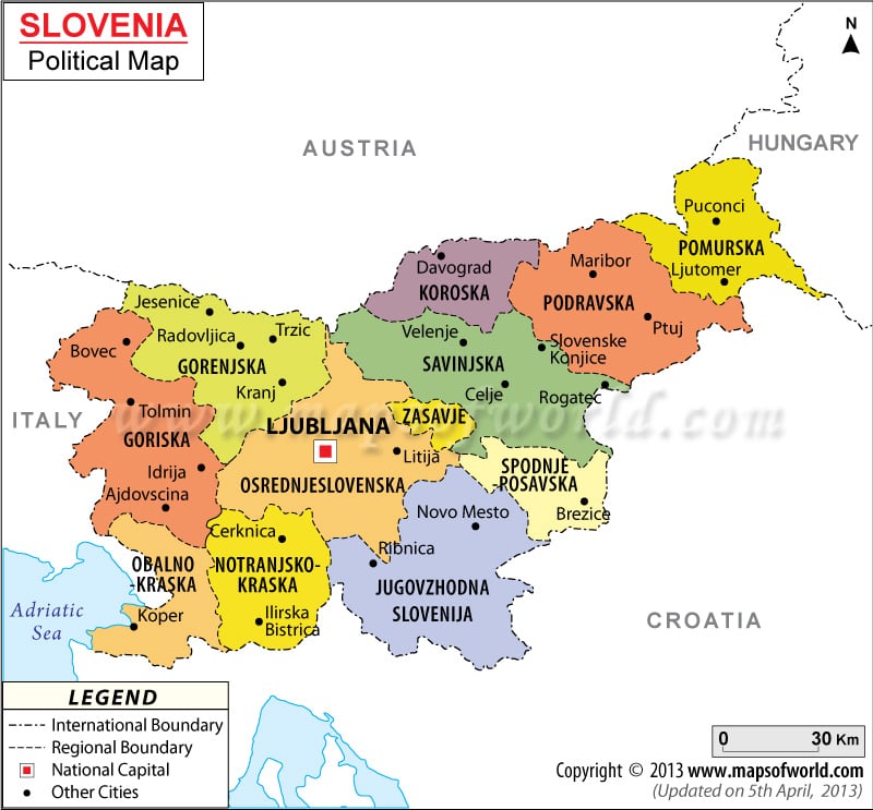
Slovenia is located in Europe and the country attained independence from Yugoslavia on 25th June 1991. Slovenia follows parliamentary republic form of government. In the political map of Slovenia, the national capital, municipalities have been highlighted by using symbols, which are explained in the legend box below the map.
Slovenia Political Features
Slovenia is a Central European country. The geographic coordinates of Slovenia are 46° 7′ North latitude and 14° 49′ East longitude. Officially, Slovenia is also known as Republic of Slovenia. The country covers an area of 20,273 square kilometers. The population of Slovenia according to the estimate of July 2007 was 2,009,245. The residents of the country are known as Slovenians.
Slovenia Cities
The important cities of Slovenia have been indicated in the political printable map of Slovenia by black dots. Some of the indicated cities of Slovenia are Ribnica, Koper, Cerknica, Idrija, Tolmin, Nova Gorica, Bovec, Trzic, Velenje, Ptuj, Maribor, Slovenj Gradec.
Slovenia Administrative Divisions
Administratively Slovenia has been divided into 182 municipalities. There are 11 urban municipalities at Slovenia, which have been highlighted in the Slovenia political printable map by different colors. The Slovenia urban municipalities are Celje, Kranj, Koper-Capodistria, Ljubljana, Maribor, Murska Sobota, Nova Gorica, Novo Mesto, Ptuj, Slovenj Gradec and Velenje. The internal boundaries of the urban municipalities have been indicated by black lines in the political printable Slovenia map.
Slovenia Capital
The capital of Slovenia is Ljubljana. The national capital is located in the central part of Slovenia. The national capital is the hub for all government bodies and administrative bodies. The geographic coordinates of Ljubljana are 46° 3′ 19″ North latitude and 14° 30′ 52″ East longitude. The capital city is at an altitude of 925 feet. The capital city is served by Ljubljana airport.
Some of the neighboring cities of Ljubljana are:
- Zgornja Siska
- Vic
- Stozice
- Spodnja Siska
- Ilovica
- Daljna Vas
- Moste
Slovenia Boundaries
The bordering countries and water bodies of Slovenia are highlighted in the map of Slovenia. Adriatic Sea borders the country in the southeastern side. The international boundaries of the country are pointed out by specific pattern of black lines. The Slovenia bordering countries are:
- Croatia to southern and eastern side
- Hungary in the northeast
- Italy on the western side
- Austria to northern side
| Name | Population | Area(km.²) | Area(mi.²) | Capital |
|---|---|---|---|---|
| Dolenjska | 136,474 | 2,675 | 1,033 | Nove Mesto |
| Gorenjska | 195,885 | 2,137 | 825 | Kranj |
| Goriska | 118,511 | 2,325 | 898 | Nova Gorica |
| Koroska | 73,296 | 1,041 | 402 | Slovenj Gradec |
| Notranjsko-kraska | 50,243 | 1,456 | 562 | Postojna |
| Obalno-kraska | 102,070 | 1,044 | 403 | Koper |
| Osrednjeslovenska | 488,364 | 2,555 | 986 | Ljubljana |
| Podravska | 310,743 | 2,170 | 838 | Maribor |
| Pomurska | 120,875 | 1,337 | 516 | Murska Sobota |
| Savinjska | 253,574 | 2,384 | 921 | Celje |
| Spodnjeposavska | 68,565 | 885 | 342 | Krsko |
| Zasavska | 45,436 | 264 | 102 | Zagorje ob Savi |
| 12 regions | 1,964,036 | 20,273 | 7,827 |
 Wall Maps
 Slovenia Government