- Neighboring Countries - Guinea, Liberia
- Continent And Regions - Africa Map
- Other Sierra Leone Maps - Sierra Leone Map, Where is Sierra Leone, Sierra Leone Blank Map, Sierra Leone Road Map, Sierra Leone Rail Map, Sierra Leone River Map, Sierra Leone Cities Map, Sierra Leone Flag
Major Location
Kambia, Mango, Port Lake, Lungi, Lunsar, Makeni, Pendembu, Magburaka, Yela, Yonibana, Western Area, Rotifunk, Moyamba, Mano, Bo, Southern, Momaligi, Shenge, Bonthe, Pujehun, Zimmi, Kailahun, Pendambu, Kanema, Jeru.
Neighbour Countries/Islands Guinea, Liberia.
Oceans, Seas, River, Bays And Canals Atlantic Ocean.
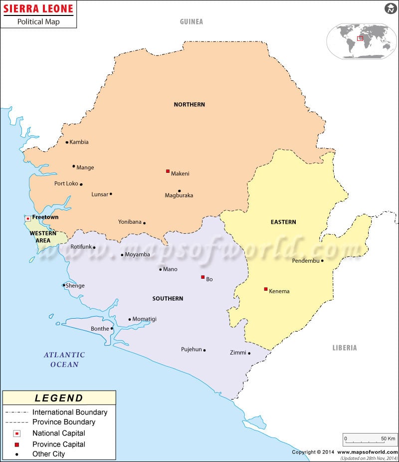
Sierra Leon, which is an African country, follows constitutional democracy. The country is also known as Republic of Sierra Leon. The country attained independence from United Kingdom on 27th April 1961. In the political map of Sierra Leon, the capital, provinces, internal and international boundaries have been indicated in a clear format. The symbols are explained in the legend box below the map.
Political Sierra Leon Features
The country of Sierra Leon is located in Western Africa. The geographic coordinates of Sierra Leon are 8° 30′ North latitude and 11° 30′ West longitude. The country has 402 kilometers of coastline.
The total area covered by Sierra Leon is 71,740 square kilometers. Sierra Leon terrain is characterized by swamps of mangroves in the coastal belts. Mountains and plateaus also constitute the terrain of the country. About 7.95% of the total land of the country is arable.
Sierra Leon Provinces and Capitals
The provinces of Sierra Leon have been highlighted in the political printable Sierra Leon map by various colors. There are three provinces and one area in the country. The Sierra Leon provinces are Southern, Eastern and Northern. Western is the area of the country. The capitals of the Sierra Leon provinces have been indicated in the political printable Sierra Leon map by white square boxes. The indicated capitals of the provinces of the country are Bo, Kanema and Makeni. The internal province boundaries are marked in the Sierra Leon political printable map.
Sierra Leon Capital
The capital of Sierra Leon is Freetown. The national capital is marked in the political Sierra Lone map by a red square box with black outline. Freetown is also the major port of Sierra Leon and the largest city of the country. The geographic coordinates of Freetown are 8° 29′ 24″ North latitude and 13° 14′ 3″ West longitude. The altitude of the capital city is 252 feet. Freetown is served by Freetown Airport. The education system of the capital city is modern and updated and there are many places of attraction at Freetown.
Sierra Leon Cities
The important cities of Sierra Leon are indicated in the political map of Sierra Leon by black dots. Some of the indicated cities of the country are:
|
|
Sierra Leon Boundaries
The international boundaries of the country are highlighted in the map of Sierra Leon by black lines of specific pattern. Liberia is situated to the southern side of the country and Guinea is positioned in the northern portion of Sierra Leon. Atlantic Ocean borders the country in the western side. The scale of the political map of Sierra Leon is also indicated in the map.
| Province | Population | Area(km.²) | Area(mi.²) | Capital |
|---|---|---|---|---|
| Eastern | 1,187,532 | 15,553 | 6,005 | Kenema |
| Northern | 1,718,240 | 35,936 | 13,875 | Makeni |
| Southern | 1,106,602 | 19,694 | 7,604 | Bo |
| Western | 950,924 | 557 | 215 | Freetown |
| 4 divisions | 4,963,298 | 71,740 | 27,699 |
Note : –Population: 2004-12 census (provisional results)

 Sierra-Leone Distance Calculator and Driving Directions