1.8K
- Neighboring Countries - Gabon, Cameroon, Central African Republic, Democratic Republic of Congo, Equatorial Guinea
- Continent And Regions - Africa Map
- Other Republic of Congo Maps - Republic of Congo Map, Where is Republic of Congo, Republic of Congo Blank Map, Republic of Congo Road Map, Republic of Congo Rail Map, Republic of Congo River Map, Republic of Congo Cities Map, Republic of Congo Political Map
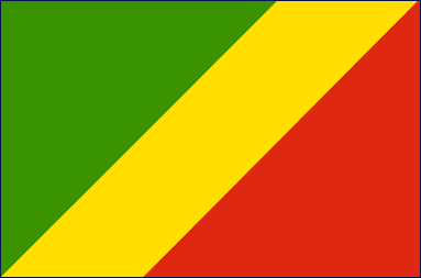
The national flag of the Republic of Congo is divided diagonally into two halves by a yellow band running through the center; the upper triangle, towards the hoist side is green and the lower triangle is red. These are the traditional Pan-African colors; it is the fifth national flag to use these colors. The Congo Brazzaville flag was initially adopted on August 18, 1958 but was abandoned in 1970. Twenty-one years later on June 10, 1991, the flag was re-introduced as the official flag of the Republic.
| Official Name: | Republic of the Congo |
| Proportion: | 2:3 |
| Adopted on: | August 18, 1958 |
| Location: | Located in Central Africa bordered by the Republic of Congo and the Atlantic Ocean, Zambia, Tanzania, Burundi, Rwanda, Uganda, Angola, Sudan and the Central African Republic |
| Capital City: | Brazzaville |
| Major Cities: | Bouenza, Plateaux, Brazzaville |
| Area: | 132,047 square miles |
| Population: | 3,686,000 |
| Currency: | Central African Frac (CFA) Franc (XAF) |
| Official Language: | French |
| National Anthem: | The Congolese |
| National symbol(s): | lion, elephant |
| National colors: | green, yellow, red |
| National anthem: | |
| Name: | “La Congolaise” (The Congolese) |
| Lyrics/Music: | Jacques TONDRA and Georges KIBANGHI/Jean ROYER and Joseph SPADILIERE |
Fact about Brazzaville flag |
| Country | Congo, Republic of (Brazzaville) |
|---|---|
| Designed by | NA |
| Adopted | September 15, 1959 |
| Revision | NA |
| Design and Colors | A diagonal tricolour of green, yellow and red radiating from the lower hoist side corner |
| Size Ratio | 2:3 |

 Facts about Republic of Congo