- Neighboring Countries - Cameroon, Sudan, Central African Republic, Libya, Niger, Nigeria
- Continent And Regions - Africa Map
- Other Chad Maps - Chad Map, Where is Chad, Chad Blank Map, Chad Road Map, Chad River Map, Chad Cities Map, Chad Flag
Chad is a landlocked country at the crossroads of Central and North Africa. It shares its boundary with Sudan to the east, Libya to the north, the Central African Republic to the south, Nigeria and Cameroon to the southwest, and Nigeria to the southwest.
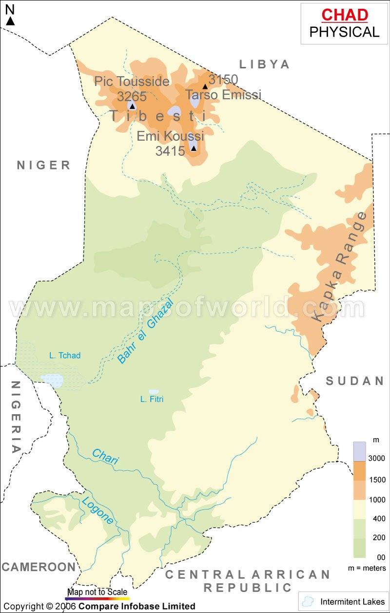
The country covers an area of 1,284,000 square kilometres (496,000 sq mi). Chad lies between latitudes 7. N and 24. N and longitude 13. E and 24. E. Chad is named after Lake Chad, the second-largest wetland in Africa. Lake Chad and other intermittent lakes can be easily identified on the map. The country’s topography is mostly flat, with the height gradually rising as we move north and east from Lake Chad. Chad has many physical features ranging from the Sahara Desert in the north to the Sahel region in central Chad to Sudanian Savanna in south the Chad Basin. Geographically based on physical structure, the country can be divided into the following areas:
Tibesti Mountains
The Tibesti Mountain ranges are located north of Chad in central Sahara. The highest point of Chad is Emi Koussi, a dormant volcano; the mountain has a height of 3,415 m (11,204 ft) lies in the Tibesti Mountains. The mountain range is adjacent to Niger between Lake Chad and the Gulf of Sidra. The range is 350 km (220 mi) in width and 480 km (300 mi) in length.
Ennedi Plateau and the Ouaddai highlands
The plateau is located in the northeast of Chad, in the regions of Ennedi-Est and Ennedi-Quest. The region is considered a part of the group of mountains known as Ennedi Massif. The area is composed of sandstone overlaying a Precambrian granite base, and its highest point is 1,450 m (4,760 ft). Quaddai Highlands is a region east of chad along the border. Together Ennedi plateau and Quaddai highlands complete the image of the sloping basin that descends towards lake chad.
Chad Basin
The Basin is the largest drainage basin in Africa. The basin is a depression and spans more than 625 miles, is 5,000 feet deep and is the largest basin in Africa centred on Lake Chad. The region contains a large area of Semi-arid desert and savanna.
Principal Rivers and Lakes of Chad
The principal rivers of Chad are Logone and Chari and their tributaries. These river systems arise in the highlands of the Central African Republic and Cameroon and flow from the southeast into lake chad. The regions receive more than 1250 millimetres of rainfall annually. The Chari River is about 1,200 kilometres long, and its volume varies from 17 Cubic metres per second during the dry season to 340 Cubic metres per second during the rainy season. The logone river is comparatively shorter and smaller in volume than Chari.
Lake Chad, the seventh-largest lake globally, is located in the Sahelian zone, a region south of the Sahara Desert. The Chari River contributes to 95 % of Lake Chad’s water. The other lakes in the region are Lake, Fitri Lake Iro, and more.
Physical Map of Neighbouring Countries

 Vacations in Chad