- Neighboring Countries - Kosovo, Serbia, Albania , Bosnia
- Continent And Regions - Europe Map
- Other Montenegro Maps - Montenegro Map, Where is Montenegro, Montenegro Blank Map, Montenegro Road Map, Montenegro Rail Map, Montenegro River Map, Montenegro Cities Map, Montenegro Physical Map, Montenegro Flag
Geographical location of Montenegro
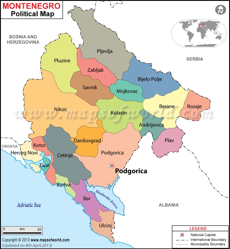
Montenegro Political Map gives the names of the large number of cities that is located in Montenegro. It also shows the international boundary of the country.
Montenegro is a southeastern European country located between the Adriatic Sea in the south-west and Serbia in the north-east.
Montenegro falls on the geographical coordinates of 42°30′ North latitude and 19°18′ East longitude. It covers an area of approximately 14,026 sq km, out of which the land covers 13,812 sq km and the water bodies cover 214 sq km. Montenegro has got a long coastline of 293.5 km. Bobotov Kuk is the highest point and the Adriatic Sea is the lowest point of Montenegro.
Bosnia and Herzegovina is located in the north-western side, Croatia in the west and Albania in the south-east.
Capital city of Montenegro
Podgorica located on the geographical coordinates of 42°26′ North latitude and 19°16′ East longitude is the national capital of Montenegro. It is situated at an elevation of 61 meters above sea level. It is highlighted on the Political Map of Montenegro by a red square box. Some of the nearby places include Zagoric, Stara Varos, Momisici, Drac and Nova Varos.
Rivers of Montenegro
The important rivers of Montenegro are shown on the Montenegro Political Map by blue color. These rivers are Pivsko Jezero, Kotorski Zaljev, Tara, Skadarsko Jezero and Kormarnica.
Cities of Montenegro
The cities of Montenegro are marked on the Montenegro Country Map by red circles. Some of these cities are Boljanici, Popov Do, Pljevija, Odzac, Kovren, Zabljak, Gornja Bukovica, Dubrovsko, Crnca, Trpezi, Rozaje, Zagrad, Sjenoste, Boan, Pluzine, Berane, Bolesestra, Gusinje, Plav, Cevo, Risan and Mahala.
| Commune | Population | Area(km.²) | Area(mi.²) |
|---|---|---|---|
| Andrijevica | 5,071 | 283 | 109 |
| Bar | 42,048 | 598 | 231 |
| Berane | 33,970 | 717 | 277 |
| Bijelo Polje | 46,051 | 924 | 357 |
| Budva | 19,218 | 122 | 47 |
| Cetinje | 16,657 | 899 | 347 |
| Danilovgrad | 18,472 | 501 | 193 |
| Herceg Novi | 30,864 | 235 | 91 |
| Kolasin | 8,380 | 897 | 346 |
| Kotor | 22,601 | 335 | 129 |
| Mojkovac | 8,622 | 367 | 142 |
| Niksic | 72,443 | 2,065 | 797 |
| Plav | 13,108 | 486 | 188 |
| Pljevlja | 30,786 | 1,346 | 520 |
| Pluzine | 3,246 | 854 | 330 |
| Podgorica | 185,937 | 1,399 | 540 |
| Rozaje | 22,964 | 432 | 167 |
| Savnik | 2,070 | 553 | 214 |
| Tivat | 14,031 | 46 | 18 |
| Ulcinj | 19,921 | 255 | 98 |
| Zabljak | 3,569 | 445 | 172 |
| 21 communes | 620,029 | 13,759 | 5,312 |

 Montenegro Facts