4.3K
- Continent And Regions - Oceania Map
- Other Marshall Islands Maps - Marshall Islands Map, Where is Marshall Islands, Marshall Islands Political Map
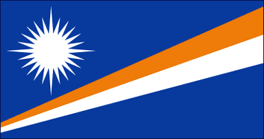
On a dark or navy blue background one orange and white diagonal stripes are seen
rising from the bottom corner of the hoisting side to the opposite corner of the flying side making two triangles. On the upper triangle in the hoisting corner there is a twenty four pointed white star with four extended hands. The ratio of the flag ‘s width to its length is10:19.
All the features of the flag symbolically describes Marshall Island ‘s location and have their distinct meanings as well.
| Official Name: | Republic of the Marshall Island |
| Capital: | Majuro Atoll |
| Location: | Lie in the pacific Ocean north of Kiribati and east of Micronesia |
| Area: | 181 Sq. km. |
| Official Languages: | Marshallese and English |
| National Flag: | Blue with a diagonal stripe divided orange over white and a white sun of 25 rays in the canton . |
| Flag Ratio: | 1:2 |
| National Anthem: | Kej Rammon Aelin Kein am Forever Marshall Islands (1991) |
| National symbol(s): | 24-rayed star |
| National colors: | blue, white, orange |
| National anthem: | |
| Name: | “Forever Marshall Islands” |
| Lyrics/Music: | Amata KABUA |
Fact about Marshall Islands flag |
| Country | Marshall Islands |
|---|---|
| Designed by | Emlain Kabua |
| Adopted | 1. May 1979 |
| Revision | NA |
| Design and Colors | A blue field with two stripes radiating from the lower hoist-side corner – orange (top) and white; charged with a white star with four large rays and twenty small rays above the two lines on the hoist side |
| Size Ratio | 10:19 |

 Marshall Islands Facts