- Neighboring Countries - Sierra Leone, Guinea, Cote d'Ivoire
- Continent And Regions - Africa Map
- Other Liberia Maps - Liberia Map, Where is Liberia, Liberia Blank Map, Liberia Road Map, Liberia Rail Map, Liberia River Map, Liberia Cities Map, Liberia Flag
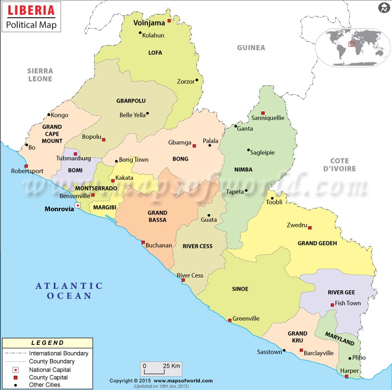
Liberia political map is helpful to all web browsers interested in knowing about the country. The geographical coordinates of Liberia are 6° 30′ North latitude and 9° 30′ West longitude. The country capital is Monrovia, situated near the coast of Atlantic Ocean. The printable map of Liberia displays details of the country, which include the counties and their capitals, national capital and the neighboring countries.
Location and Geography
Liberia occupies a total area of 111, 370 square kilometers. The area covered by land is 96, 320 square kilometers and 15, 050 square kilometers is covered by waterbodies. The geographical coordinates of Liberia are 6° 30′ North latitude and 9° 30′ West longitude respectively. The coastline of the country extends upto 579 kilometers. Mount Wuteve is the highest point situated at 1,380 meters above sea level. The lowest point is Atlantic Ocean.
Capital of Liberia
The country capital is Monrovia, situated near the coast of Atlantic Ocean. A red star on the map of Liberia is used to indicate the capital. The latitudinal and longitudinal extent of the city are 6°18’38”North and 10°48’17”West respectively. The nearby cities and towns are Gbenang, Coffeelo, Kapebli, Crown Hill, Kpaia, Bassa Community, Vai Town, Westpoint and Clara Town. Monrovia Spriggs Payne and Monrovia Roberts International are the two airports in the city.
Counties and Capitals
In the political map of Liberia, the county capitals are pointed with green squares. The county capitals marked in the map are listed below:
|
|
|
|
|
|
|
|
|
|
|
|
|
|
Important Cities of Liberia
The Liberia map also features some of the important cities of Liberia. They are marked with black dots. Some of the cities are:
|
|
|
|
|
|
|
|
|
|
|
|
|
|
| County | Population | Area(km.²) | Area(mi.²) | Capital |
|---|---|---|---|---|
| Bomi | 82,036 | 1,955 | 755 | Tubmanburg |
| Bong | 328,919 | 8,099 | 3,127 | Gbarnga |
| Gbarpolu | 83,758 | 7,723 | 2,982 | Bopolu |
| Grand Bassa | 224,839 | 8,759 | 3,382 | Buchanan |
| Grand Cape Mount | 129,055 | 5,827 | 2,250 | Robertsport |
| Grand Gedeh | 126,146 | 17,029 | 6,575 | Zwedru |
| Grand Kru | 57,106 | 2,299 | 888 | Barclayville |
| Lofa | 270,114 | 11,637 | 4,493 | Voinjama |
| Margibi | 199,689 | 3,263 | 1,260 | Kakata |
| Maryland | 136,404 | 3,052 | 1,178 | Harper |
| Montserrado | 1,144,806 | 2,740 | 1,058 | Bensonville |
| Nimba | 468,088 | 12,043 | 4,650 | Sanniquellie |
| Rivercess | 65,862 | 4,385 | 1,693 | Cestos City |
| River Gee | 67,318 | Fish Town | ||
| Sinoe | 104,932 | 10,254 | 3,959 | Greenville |
| 15 counties | 3,489,072 | 99,065 | 38,250 |

 Liberia Facts