|
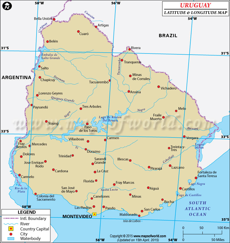
| Decription: Find Uruguay latitude and longitude map showing comprehensive details including cities, roads, towns, airports and much more. | Disclaimer |
View detailed world maps that offer a global perspective—political, physical, and more.
Explore maps that visualize data on topics like population, climate, economy, and beyond.
Navigate the world with maps that guide your journeys—country and city maps for travelers.
Learn, discover, and share with educational maps, geography trivia, and cartographic insights—ideal for classrooms and curious minds.
FBrowse quick-reference lists for airports, area codes, capitals, postal codes, time zones, and more—organized for easy access.
Explore powerful mapping tools and services.
Order custom maps tailored to your most specific needs, whether for business, education, travel, or more!
Learn moreView detailed world maps that offer a global perspective—political, physical, and more.
Explore maps that visualize data on topics like population, climate, economy, and beyond.
Navigate the world with maps that guide your journeys—country and city maps for travelers.
Learn, discover, and share with educational maps, geography trivia, and cartographic insights—ideal for classrooms and curious minds.
FBrowse quick-reference lists for airports, area codes, capitals, postal codes, time zones, and more—organized for easy access.
Explore powerful mapping tools and services.
Search For Latitude & Longitude Map
Or
Latitude
Longitude
Or
Area
* Put South & West values with minus ( - ) sign.

|
| Decription: Find Uruguay latitude and longitude map showing comprehensive details including cities, roads, towns, airports and much more. | Disclaimer |
Close Disclaimer : All efforts have been made to make this image accurate. However MapSherpa, Inc, its directors and employees do not own any responsibility for the correctness or authenticity of the same. |
| Locations | Latitude | Longitude |
| Aigua | 34°13'S | 54°46'W |
| Algorta | 32°25'S | 57°23'W |
| Arapey Grande | 30°55'S | 57°49'W |
| Artigas | 30°20'S | 56°30'W |
| Bella Union | 30°15'S | 57°40'W |
| Blanquillo | 32°53'S | 55°37'W |
| Canelones | 34°32'S | 56°17'W |
| Cardona | 33°53'S | 57°18'W |
| Carmelo | 34°00'S | 58°20'W |
| Castillos | 34°12'S | 53°52'W |
| Cerro Chato | 33°06'S | 55°08'W |
| Chuy | 33°41'S | 53°27'W |
| Colonia del Sacramento | 34°25'S | 57°50'W |
| Constitucion | 31°00'S | 57°50'W |
| Dolores | 33°34'S | 58°15'W |
| Durazno | 33°25'S | 56°31'W |
| Florida | 34°07'S | 56°10'W |
| Fraile Muerto | 32°31'S | 54°32'W |
| Fray Bentos | 33°10'S | 58°15'W |
| Jose Batlle y Ordonez | 33°20'S | 55°10'W |
| Juan L. Lacaze | 34°26'S | 57°25'W |
| Locations | Latitude | Longitude |
| Las Piedras | 34°44'S | 56°14'W |
| Lascano | 33°35'S | 54°12'W |
| Maldonado | 34°59'S | 55°0'W |
| Melo | 32°20'S | 54°10'W |
| Mercedes | 33°12'S | 58°0'W |
| Minas | 34°20'S | 55°10'W |
| Monatevideo | 34°50'S | 56°11'W |
| Negro | 33°24'S | 58°22'W |
| Nueva palmira | 33°52'S | 58°20'W |
| Pando | 34°44'S | 56°0'W |
| Paysandu | 32°19'S | 58°08'W |
| Queguay Grande | 32°09'S | 58°09'W |
| Rocha | 34°30'S | 54°25'W |
| Salto | 31°27'S | 57°50'W |
| Santa Clara de Olimar | 32°50'S | 54°54'W |
| Santa Lucia | 34°27'S | 56°24'W |
| Sarandi del Yi | 33°18'S | 55°38'W |
| Soriano | 33°24'S | 58°19'W |
| Tacuarembo | 31°45'S | 56°0'W |
| Vergara | 32°56'S | 53°57'W |
| Yi | 33°7'S | 57°8'W |

Copyright © 2024 mapsofworld.com. All Rights Reserved


