Tajikistan Latitude and Longitude Map
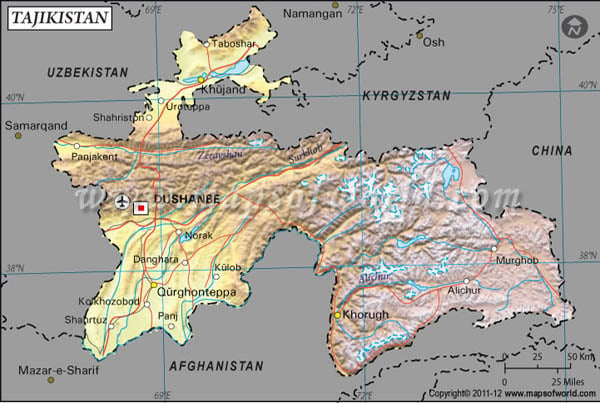
Tajikistan's latitude and longitude is 39° 00' N and 71° 00' E . Below is the map of Tajikistan showing major towns, roads, airports with latitudes and longitudes plotted on it.
Search For Latitude & Longitude Map
Or
Latitude
Longitude
Or
Area
* Put South & West values with minus ( - ) sign.

|
| Description: Find Tajikistan latitude and longitude map showing comprehensive details including cities, roads, towns, airports and much more. | Disclaimer |
Tajikistan is situated in the central part of Asia and its latitude and longitude readings are 39° 00' North and 71° 00' East.
Tajikistan has a Standard Time that runs five hours ahead than the Greenwich Mean Time. The weather of Tajikistan has the features of both continental and subtropical climates. Changes in the climate are noticed according to the altitude. In the lower elevation areas the summer weather is very hot but dry and winter temperature goes often below 0° C and is very cold. Annual rainfall also varies according to the location. Precipitation is high in the glacier valley area of Tajikistan.
| Locations | Latitude | Longitude |
| Communism Pk / Kommunizma, Pik | 39°00'N | 72°02'E |
| Dushanbe | 38°33'N | 68°48'E |
| Garm | 39°00'N | 70°20'E |
| Garmo, Qullai / Kommunizma, Pik | 39°00'N | 72°02'E |
| Khodzent / Khujand | 40°17'N | 69°37'E |
| Khorugh | 37°30'N | 71°36'E |
| Khudzhand / Khujand | 40°17'N | 69°37'E |
| Khujand | 40°17'N | 69°37'E |
| Kommunizma, Pik | 39°00'N | 72°02'E |
| Kulob | 37°55'N | 69°50'E |
| Kulyab / Kulob | 37°55'N | 69°50'E |
| Leninabad / Khujand | 40°17'N | 69°37'E |
| Murgab / Murghob | 38°10'N | 74°02'E |
| Murghob | 38°10'N | 74°02'E |
| Pamier | 37°40'N | 73°0'E |


