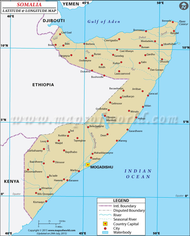
Somalia Latitude and Longitude Map
Search For Latitude & Longitude Map
Or
Latitude
Longitude
Or
Area
* Put South & West values with minus ( - ) sign.
| Description : Find Somalia latitude and longitude map showing comprehensive details including cities, roads, towns, airports and much more. | Disclaimer |
Close Disclaimer : All efforts have been made to make this image accurate. However MapSherpa, Inc, its directors and employees do not own any responsibility for the correctness or authenticity of the same. |
The country of Somalia includes 637,657 square kilometers of area in the Eastern Africa. The terrain of Somalia is graced with almost plain and flat land. The northern part of Somalia is comparatively high as this is a hilly region. Extreme climatic condition of desert dominates here. The southern area is arid and damp in monsoon, while moderate weather is found in northern part of Somalia. The latitude and the longitude of Mogadishu, the capital of Somalia, are 2° 04' N and 45° 22' E respectively. The time followed in Somalia is observed as UTC+3 which signify that Somalia's standard time is 8 hours ahead from Washington.
| Locations | Latitude | Longitude |
| Asir, Ras, | 11°55'N | 51°10'E |
| Baardeere/Bardera | 02°20'N | 42°27'E |
| Baidoa | 03°08'N | 43°30'E |
| Bardera | 02°20'N | 42°27'E |
| Baydhabo/Baidoa | 03°08'N | 43°30'E |
| Beled Weyne/Belet Uen | 04°30'N | 45°05'E |
| Belet Uen | 04°30'N | 45°05'E |
| Bender Beila | 09°30'N | 50°48'E |
| Berbera | 10°30'N | 45°02'E |
| Bereda | 11°45'N | 51°00'E |
| Boosaaso/Bosaso | 11°12'N | 49°18'E |
| Bosaso | 11°12'N | 49°18'E |
| Bur Acaba | 03°12'N | 44°20'E |
| Burao | 09°32'N | 45°32'E |
| Buur Hakaba/Bur Acaba | 03°12'N | 44°20'E |
| Caseyr, Rass/Asir, Ras | 11°55'N | 51°10'E |
| Ceerigaabo/Erigavo | 10°35'N | 47°20'E |
| Chiamboni | 01°39'S | 41°35'E |
| Chismaio | 00°22'S | 42°32'E |
| Dif | 00°59'N | 00°56'E |
| Eil | 08°00'N | 49°50'E |
| El Dere | 03°50'N | 47°08'E |
| El Gal | 10°58'N | 50°20'W |
| Erigavo | 10°35'N | 47°20'E |
| Locations | Latitude | Longitude |
| Ferfer | 05°04'N | 45°09'E |
| Galcaio | 06°30'N | 47°30'E |
| Gardo | 09°30'N | 49°06'E |
| Garoe | 08°25'N | 48°33'E |
| Garoowe/France | 08°25'N | 48°33'E |
| Giuba | 01°30'N | 42°35'E |
| Guardafui, C./Asir, Ras | 11°55'N | 51°10'E |
| Hafun, Ras | 10°29'N | 51°30'E |
| Hargeisa | 09°30'N | 44°02'E |
| Juba/Giuba | 01°30'N | 42°35'E |
| Karin | 10°50'N | 45°52'E |
| Kismayu/Chisimaio | 00°22'S | 42°32'E |
| Laas Caanood/Las Anod | 08°26'N | 47°19'E |
| Las Anod | 08°26'N | 47°19'E |
| Lugh Ganana | 03°48'N | 42°34'E |
| Luuq=Lugh Ganana | 03°48'N | 42°34'E |
| Merca | 01°48'N | 44°50'E |
| Mogadishu/Muqdisho | 02°02'N | 45°25'E |
| Muqdisho | 02°02'N | 45°25'E |
| Obbia | 05°25'N | 48°30'E |
| Qardho/Gardo | 09°30'N | 49°06'E |
| Scebeli Wabi | 2°0'N | 44°0'E |
| Zeila | 11°21'N | 43°30'E |


