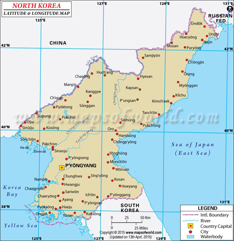
The
latitude and longitude of North Korea is 40° North and 127° East. The total area of North Korea is 120,540 square kilometers.
North Korea falls within the Tropic of Cancer and the Arctic Circle. As
latitude of North Korea falls in the temperate zone, the climatic condition is more or less temperate in nature with scanty rainfall in the winters and humid summers.
The
latitude and longitude of the capital of North Korea, Pyongyang, is 39° North and 125°45' East. The
longitude of North Korea is to the extreme east of the Prime Meridian. The standard time of North Korea thus is about nine hours ahead of the Greenwich Mean Time. There is only one
time zone in North Korea . The Washington DC standard time is fourteen hours behind North Korea.
PB18.03.2017
| Locations |
Latitude |
Longitude |
| Anbyon | 39°01'N | 127°35'E |
| Anju | 39°36'N | 125°40'E |
| Chaeryong | 38°24'N | 125°36'E |
| Changdo-ri | 38°30'N | 127°40'E |
| Changhungni | 40°24'N | 128°19'E |
| Changjin | 40°23'N | 127°15'E |
| Changjin-Chosuji | 40°30'N | 127°15'E |
| Changyon | 38°15'N | 125°06'E |
| Chiha-ri | 38°40'N | 126°30'E |
| Chinnampo/Namp'o | 38°52'N | 125°10'E |
| Cho-do | 38°30'N | 124°40'E |
| Chongjin | 41°47'N | 129°50'E |
| Chongju | 39°40'N | 125°05'E |
| Ch'osan | 40°50'N | 125°47'E |
| Chunggang-up | 41°48'N | 126°48'E |
| Chunghwa | 38°52'N | 125°47'E |
| Chuuronjang | 41°35'N | 129°40'E |
| Hachon | 41°29'N | 129°02'E |
| Haeju | 34°34'N | 126°35'E |
| Hamhung | 39°54'N | 127°30'E |
| Hapsu | 41°13'N | 128°51'E |
| Hoeamdong | 42°30'N | 130°16'E |
| Hoeryong | 42°30'N | 129°45'E |
| Hoeyang | 38°43'N | 127°36'E |
| Hongwon | 40°00'N | 127°56'E |
| Huch'ang | 41°25'N | 127°02'E |
| Hungnam | 39°49'N | 127°45'E |
| Hyesan | 41°20'N | 128°10'E |
| Inpundong | 41°25'N | 126°34'E |
| Irhyangdong | 41°15'N | 129°30'E |
| Kaesong | 37°58'N | 126°35'E |
| Kangdong | 39°09'N | 126°05'E |
| Kanggye | 41°00'N | 126°35'E |
| Kapsan | 41°04'N | 128°19'E |
| Kasan-dong | 41°18'N | 126°55'E |
| Kilchu | 40°57'N | 129°25'E |
| Kimch'aek | 40°40'N | 129°10'E |
| Koin-Dong | 40°28'N | 126°18'E |
| Kojo | 38°58'N | 127°58'E |
| Koksan | 38°46'N | 126°40'E |
| Kosong | 38°40'N | 128°22'E |
| Kowon | 39°26'N | 127°14'E |
| Kujang | 39°57'N | 126°01'E |
| Kumch'on | 38°10'N | 126°29'E |
| Kuup-tong | 40°45'N | 126°01'E |
| Kwangdaeri | 40°31'N | 127°32'E |
| Kyongsong | 41°35'N | 129°36'E |
| Manp'O | 41°06'N | 126°24'E |
| Manpojin/Manp'o | 41°06'N | 126°24'E |
| Munch on | 39°14'N | 127°19'E |
| Musan | 42°12'N | 129°12'E |
| Musudan | 40°50'N | 129°43'E |
| Najin | 42°12'N | 130°15'E |
| Nam-ch'on | 38°15'N | 126°26'E |
| Namchonjom/Nam-ch'on | 38°15'N | 126°26'E |
| Namp'o | 38°52'N | 125°10'E |
| Nanam | 41°44'N | 129°40'E |
| Ondaejin | 41°34'N | 129°40'E |
| Ongjjin | 37°56'N | 125°21'E |
| Oro | 40°01'N | 127°27'E |
| Panmunjom | 37°59'N | 126°38'E |
| Pugodong | 42°05'N | 130°0'E |
| Pujon-Chosuji | 40°35'N | 127°35'E |
| Pukchin | 40°12'N | 125°45'E |
| Pukch'ong | 40°14'N | 128°10'E |
| P'ungsan | 40°50'N | 128°09'E |
| Puryong | 42°05'N | 129°43'E |
| Pyoktong | 40°50'N | 125°50'E |
| Pyonggang | 38°24'N | 127°17'E |
| P'yongyang | 39°0'N | 125°30'E |
| Sakchu | 40°23'N | 125°2'E |
| Sariwon | 38°31'N | 125°46'E |
| Simpungdong | 40°56'N | 129°29'E |
| Sinchang-ni | 39°24'N | 126°8'E |
| Singosan | 38°52'N | 127°34'E |
| Sinmak | 38°25'N | 126°14'E |
| Sinp'o | 40°0'N | 128°13'E |
| Sohori | 33°13'N | 126°34'E |
| Songnim | 38°45'N | 125°39'E |
| Sosura | 42°16'N | 130°36'E |
| Taegwan | 40°13'N | 125°12'E |
| Tongchon-ni | 39°50'N | 127°25'E |
| Tongyang | 39°9'N | 126°53'E |
| Uiju | 40°15'N | 124°35'E |
| Unggi | 42°16'N | 130°28'E |
| Wonsan | 39°11'N | 127°27'E |
| Yonan | 37°55'N | 126°11'E |
| Yongamp's | 39°56'N | 124°23'E |
Last Updated on: September 18th, 2017
