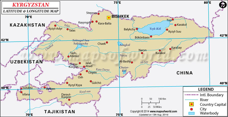
The Kyrgyz Republic in Central Asia has the geographic coordinates of 41°00'N
latitude and 75°00'E
longitude . Kyrgyzstan is a land of great natural beauty and a proud and strong people influenced by nomadic traditions.
The expansive latitude and longitude of Kyrgyzstan span across an area of 199,900 sq km making it the 86 th country in the world in terms of land area. The capital of Kyrgyzstan is Bishkek with geographic location at 42°52'N latitude and 74°36'E longitude .
Kyrgyzstan was granted independence from Russia on December 21, 1991, after the breakdown of the Soviet Union. Presently the latitude and longitude of Kyrgyzstan accommodates several districts - Batken, Chui, Jalal-Abad, Naryn, Osh, Talas and Issyk-Kul. The states are divided into districts called Raion which are governed by Akims.
Kyrgyzstan is known as the Switzerland of Central Asia; about 80% of the land mass is composed of the Tien Shan Mountain Range and its many valleys and river basins. The highest peak is the Jengish Chokusu Mountain also known as Pik Pobedy, standing at a height of 7,439 m. Kyrgyzstan's geographic location is dominated by the dry continental type of climate which reaches subzero temperatures in winter. The climate varies from region to region and differs according to the latitudinal and longitudinal location of the Tien Shan and the Fergana Valley. The Mountains are almost always under snow while the valley regions are warm in summer.
Latitude and Longitude of Kyrgyzstan |
|---|
| Location | Latitude | Longitude |
|---|
| Bishkek | 42°54'N | 74°46'E |
| Frunze / Bishkek | 42°54'N | 74°46'E |
| Issyk-Kul, Ozero / Ysyk-Kol | 42°25'N | 77°15'E |
| Karakol | 42°30'N | 78°20'E |
| Kizyl-Koya | 40°16'N | 72°08'E |
| Naryn | 41°26'N | 75°58'E |
| Osh | 40°37'N | 72°49'E |
| Pobedy Pik | 42°0'N | 79°58'E |
| Przhevalsk / Karakol | 42°30'N | 78°20'E |
| Sary-Tash | 39°44'N | 73°15'E |
| Tash-Komur | 41°40'N | 72°10'E |
| Tokmak | 42°49'N | 75°15'E |
| Ysyk-Kol | 42°25'N | 77°15'E |
Last Updated on: November 17th, 2017


