The State of
Kuwait is a relatively small Middle Eastern Arabic Nationality, with the
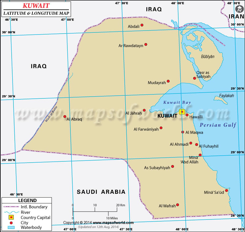
Geographic Coordinates of 29°30'N, 45°45'E.
Known as Dawlat al-Kuwayt in Arabic,
Kuwait means Fortress near the Water. It is named after the Kout or castle of the royal prince of the Khaled tribe, located near the Persian Gulf. The capital of
Kuwait is Kuwait City with the
longitude and latitude of 29°22'N and 47°58'E.
Kuwait has a total area of 17,820 sq km. This relatively small land area is blessed by its
geographic coordinates with one of the richest crude oil reserves in the world. The population of
Kuwait is 2,505,559 with the majority being ethnic Kuwaitis. The remaining are Arabs, South Asians and Iranians.
The
latitude and longitude of Kuwait ensures a hot summer through the months of June to September. Winters are cool, wet and prone to occasional cloudbursts, through the periods of January to March.
Kuwait's geographic location makes it vulnerable to Thunderstorms and hailstorms during the months of November, March and April. Sandstorms and Dust Storms are common throughout the year, especially in the period from March to August. Kuwait's terrain is mostly flat and given to desert plains.
Latitude and Longitude of Kuwait |
|---|
| Location | Latitude | Longitude |
|---|
| Al Bahrah |
29°40'N |
47°52'E |
| Al Jahrah |
29°25'N |
47°40'E |
| Al Kuwayt |
29°30'N |
48°00'E |
| Al Maqwa', |
29°10'N |
47°59'E |
| Al Matla |
29°24'N |
47°40'E |
| Bi'r Mutribah |
29°54'N |
47°17'E |
| Bubiyan |
29°45'N |
48°15'E |
| Burqan |
29°00'N |
47°57'E |
| Kuwait/Al Kuwayt |
29°30'N |
48°00'E |
| Mina'al Ahmadi |
29°05M |
48°10'E |
Last Updated on: November 17th, 2017


