logo


Kazakhstan Latitude and Longitude Map

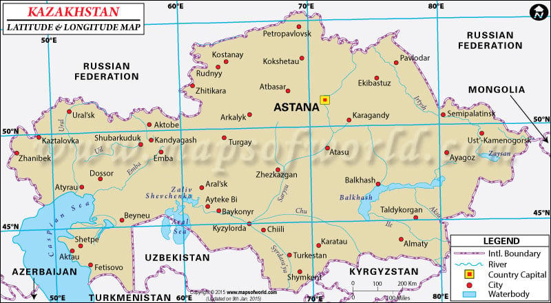
Kazakhstan's latitude and longitude is 48° 00' N and 68° 00' E . Below is the map of Kazakhstan showing major towns, roads, airports with latitudes and longitudes plotted on it.
Kazakhstan Latitude and Longitude Map Russian Federation Lat Long Map Mongolia Lat Long Map China Lat Long Map Kyrgyzstan Lat Long Map China Lat Long Map Uzbekistan Lat Long Map Turkmenistan Lat Long Map Tajikistan Lat Long Map Azerbaijan Lat Long Map Georgia Lat Long Map
Description : Find Kazakhstan latitude and longitude map showing comprehensive details including cities, roads, towns, airports and much more. Disclaimer
×

Disclaimer  :  All efforts have been made to make this image accurate. However MapSherpa, Inc, its directors and employees do not own any responsibility for the correctness or authenticity of the same.


Search For Latitude & Longitude Map

By Country

Or

Latitude

Longitude

Or

Area

* Put South & West values with minus ( - ) sign.

The Republic of Kazakhstan , located in the heartlands of Central Asia has the geographic coordinates of 48°00'N latitude and 68°00'E longitude.
The latitude and longitude of Kazakhstan spans across an enormous area of diverse terrain, measuring up to 2,717,300 sq km. Due to its expansive Latitude and Longitude , Kazakhstan has the ninth largest land area in the world and is also the biggest landlocked country. The capital of Kazakhstan is Astana, with a latitude and longitude of 51°10'N and 71°30'E respectively. The biggest city in Kazakhstan by area is Almaty with the geographic coordinates of 43°15'N latitude and 76°57'E longitude .

Because of its latitude and longitude, Kazakhstan has a typical continental climate with freezing winters and very hot summers. The Terrain is varied, stretching from the River Volga to the Altai mountain range and from the West Siberian plains to the Central Asian deserts. The majority of land is arid and semi arid in nature, consisting as it is of the semi desert steppes of Central Asia. Kazakhstan is one of the largest producers of wheat in the world and agriculture accounts for 13.6% of its GDP. Kazakhstan's geographic location gives it access to a wealth of Natural resources like fossil fuel and mineral deposits.


Latitude and Longitude of Kazakhstan

LocationLatitudeLongitude
Abay 49°38'N72°52'E
Akmolinsk/Astana51°10'N71°30'E
Aksay51°11'N53°00'E
Aktogay46°57'N79°40'E
Aktyubinsk/Aqtobe50°17'N57°10'E
Alga49°53'N57°20'E
Alma Ata/Almaty43°15'N76°57'E
Almaty43°15'N76°57'E
amangeldy50°10'N65°10'E
Aqmola/Astana51°10'N71°30'E
Aqtau43°39'N51°12'E
Aqtobe50°17'N57°10'E
Aral46°41'N61°45'E
Aralsk/Aral46°41'N61°45'E
Arkalyk/Arqalyk50°13'N66°50'E
Arqalyk50°13'N66°50'E
Arys42°26'N68°48'E
Astana51°10'N71°30'E
Atasu48°30'N71°00'E
Atbasar51°48'N68°20'E
Atyrau47°05'N52°00'E
Ayaguz48°10'N80°10'E
Balkhash/Balqash46°50'N74°50'E
Balkhash, Ozero/Balqash Kol46°00'N74°50'E
Balqash Kol46°00'N74°50'E
Bayanauyl50°45'N75°45'E
Baykonur/Bayqongyr47°48'N65°50'E
Bayqongyr47°48'N65°50'E
Beyneu45°18'N55°09'E
Burlyu-Tyube46°30'N79°10'E
Chapayev50°25'N51°10'E
Chelkar/Shalqar47°48'N59°39'E
Chelkar Tengiz, Solonchak48°05'N63°07'E
Chilli/Shieli44°20'N66°15'E
Chimkent/Shymkent42°18'N69°36'E
Chu/Shu43°36'N73°42'E
Chuy/Shu45°00'N67°44'E
Dzhambul/Taraz42°54'N71°22'E
Dzhezkazgan =Zhezqazghan47°44'N67°40'E
Ekibastuz51°50'N75°10'E
Emba48°50'N58°08'E
Emba46°55'N53°28'E
Embi/Emba48°50'N58°08'E
Embi/Emba46°55'N53°28'E
Fort Shevchenko44°35'N50°23'E
Gulshad46°45'N74°25'E
Guryev/Atyrau47°05'N52°00'E
Ile45°53'N77°10'E
Ili/Ile45°53'N77°10'E
Kachiry53°10'N75°50'E
Kalmykovo49°00'N51°47'E
Kapchagai/Qapshaghay43°51'N77°14'E
Karabutak/Qarabutaq49°59'N60°14'E
 
LocationLatitudeLongitude
Karaganda/Qaraghandy49°50'N73°10'E
Karagayly49°26'N76°00'E
Karagiyem, Vpadina43°27'N51°45'E
Karagiye Depression/Karagiye, Vpadina43°27'N51°45'E
Karatau, Khrebet/Qaratau43°30'N69°30'E
Karazhal48°02'N70°49'E
Karkaralinsk/Qarqaraly49°26'N75°30'E
Karsakpay47°55'N66°40'E
Kentau43°32'N68°36'E
Kokchetav/Kokshetau53°20'N69°25'E
Kokshetau53°20'N69°25'E
Koschagyl46°40'N54°00'E
Kounradskiy46°59'N75°00'E
Kulsary46°59'N54°01'E
Kustanay/Qostanay53°10'N63°35'E
Kzyl-Orda/Qyzylorda44°48'N65°28'E
Leninogorsk50°20'N83°30'E
Logovoy=Qualan42°55'N72°43'E
Makat47°39'N53°19'E
Makinsk53°37'N70°26'E
Mangyshiak Polustrov44°30'N52°30'E
Moyynty47°10'N7°.18'E
Novokazalinsk/Zhangaqazaly45°48'N62°06'E
Oktabrsk/Oktyzabrsk49°28'N57°25'E
Oktyabrsk 49°28'N57°25'E
Oral/Zhayyq47°0'N51°48'E
Oral51°20'N51°20'E
Oskemen50°0'N82°36'E
Panfilov44°10'N80°0'E
Pavlodar52°33'N77°0'E
Petropavl54°53'N69°13'E
Petropavlovsk - Petropavl54°53'N69°13'E
Qapshaghay43°51'N77°14'E
Qarabutaq49°59'N60°14'E
Qaraghandy49°50'N73°10'E
Qaratau43°10'N70°28'E
Qarqaraly 49°26'N75°30'E
Qostanay53°10'N63°35'E
Qulan42°55'N72°43'E
Qyzylorda44°48'N65°28'E
Ridder/Leninogorsk50°20'N83°30'W
Rudnyy52°57'N63°7'E
Saryshagan 46°12'N73°38'E
Semey650°30'N80°10'E
Tengiz Ozero50°30'N69°0'E
Turkestan/Turkistan43°17'N68°16'E
Turkistan43°17'N68°16'E
Uzen43°29'N52°54'E
Zaysan47°28'N84°52'E
Zhailma51°37'N61°33'E
Zhayyq47°0'N51°48'E
Zyryan49°43'N84°20'E


Last Updated on: November 17th, 2017