logo


Cuba Latitude and Longitude Map

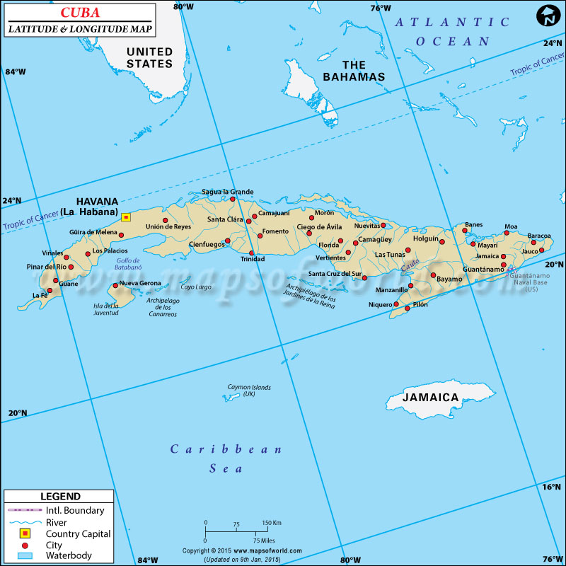
Cuba's latitude and longitude is 21° 30' N and 80° 00' W . Below is the map of Cuba showing major towns, roads, airports with latitudes and longitudes plotted on it.
Cuba Latitude and Longitude Map USA Lat Long The Bahamas Lat Long Jamaica Lat Long Caymon Islands ( UK)
Description : Find Cuba latitude and longitude map showing comprehensive details including cities, roads, towns, airports and much more. Disclaimer
×

Disclaimer  :  All efforts have been made to make this image accurate. However MapSherpa, Inc, its directors and employees do not own any responsibility for the correctness or authenticity of the same.


Search For Latitude & Longitude Map

By Country

Or

Latitude

Longitude

Or

Area

* Put South & West values with minus ( - ) sign.

Cuba is located within the latitude and longitude of 21° 30 N, 80 º 00 W. Cuba is situated on Central America.

The latitude and longitude of Cuba covers 110,860 square kilometer of total land. The capital city of Cuba is Havana . The latitude and longitude of Havana, the capital city of Cuba is 23º 08' N, 82º 22' W.

The climate within the latitude and longitude of Cuba is tropical in nature. Prevalence of trade winds helps to cool down much of the areas of Cuba .

The area within this latitude and longitude of Cuba dry season lasts from November to April and rainy season lasts from May to October. This latitude and longitude of Cuba includes a specific kind of landscape which is mostly flat, and in the southeast part of Cuba some uneven hills and mountains can also be found.

Latitude and Longitude of Cuba

LocationLatitudeLongitude
Antilla20°40'N75°50'W
Bahia Honda22°54'N83°10'W
Banes21°00'N75°42'W
Baracoa20°20'N74°30'W
Batabano22°40'N82°20'W
Batabano, G. de22°30'N82°30'W
Bayamo20°20'N76°40'W
Caibarien22°30'N79°30'W
Camaguey21°20'N78°00'W
Canarreos, Arch.de los21°35'N81°40'W
Cardenas23°00'N81°30'W
Cayo Romano22°00'N78°00'W
Ciego de Avila21°50'N78°50'W
Cienfuegos22°10'N80°30'W
Colon22°42'N80°54'W
Corrientes, C.21°43'N84°30'W
Cruz, C.19°50'N77°50'W
Florida21°32'N78°14'W
Gibara21°09'N76°11'W
Guacanayabo, G. de20°40'N77°20'W
Guanabaco23°08'N82°18'W
Guanajay22°56'N82°42'W
Guane22°10'N84°07'W
Guantanamo20°10'N75°14'W
Guines22°50'N82°00'W
Havana = La Habana23°08'N82°22'W
Holguin20°50'N76°20'W
Jaguey Grande04°25'S37°45'W
Jardines de la Reina, Arch. de los20°50'N78°50'W
Jovellanos22°40'N81°10'W
Jucaro21°37'N78°51'W
 
LocationLatitudeLongitude
Juventud, I. de la 21°40'N82°40'W
La Esperanza22°46'N83°44'W
La Fe22°02'N84°15'W
La Habana23°08'N82°22'W
Los Palacios22°35'N83°15'W
Maestra, Sierra20°15'N77°0'W
Maisi20°17'N74°09'W
Maisi, Pta. De, 20°10'N74°10'W
Manzanillo 20°20M77°31'W
Marianao23°08'N82°24'W
Matanzas23°0'N81°40'W
Mayari20°40'N75°41'W
Mao20°40'N74°56'W
Moron22°08'N78°39'W
Nueva Gerona21°53'N82°49'W
Nuevitas21°30'N77°20'W
Palma Soriano20°15'N76°0'W
Pinar del Rio22°26'N83°40'W
Placetas22°15'N79°44'W
Puerto Manoti21°22'N76°50'W
Puerto Padre21°13'N76°35'W
Romano Cayo22°0'N77°30'W
San Antonio de los Cobres22°54'N82°31'W
San Luis22°17'N83°46'W
Sancti Spiritus21°52'N79°33'W
Santa Clara 22°20'N80°0'W
Santa Cruz del Sur, 20°44'N78°0'W
Trinidad21°48'N80°0'W
Tunas de Zaza21°39'N79°34'W
Victoria de las Tunas20°58'N76°59'W

Last Updated on: November 10th, 2017