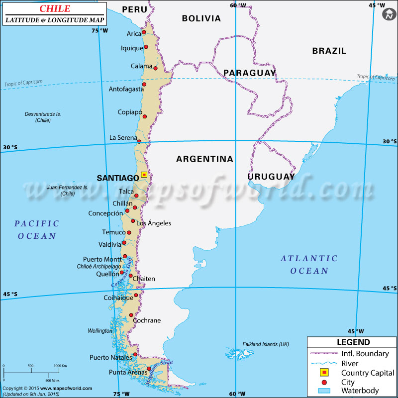
| Location | Latitude | Longitude |
|---|
| Aguas Blancas | 24°15'S | 69°55'W |
| Alemania | 25°10'S | 69°55'W |
| Altamira | 25°47'S | 69°51'W |
| Alto Del Cermen | 28°46'S | 70°30'W |
| Alto del Inca | 24°10'S | 68°10'W |
| Ancud | 42°00'S | 73°50'W |
| Ancud, G. de | 42°00'S | 73°00'W |
| Andacollo | 30°14'S | 71°06'W |
| Angamose, Punta | 23°01'S | 70°32'W |
| Angol | 37°56'S | 72°45'W |
| Antofagasta | 23°50'S | 70°30'W |
| Arauco | 37°16'S | 73°25'W |
| Arica | 18°32'S | 70°20'W |
| Ascotan | 21°45'S | 68°17'W |
| Atacama | 27°30'S | 70°00'W |
| Atacama, Desierto de | 24°00'S | 69°20'W |
| Atacama, Salar de | 23°30'S | 68°20'W |
| Balmaceda | 46°00'S | 71°50'W |
| Baquedano | 23°20'S | 69°52'W |
| Bascunan, C. | 28°52'S | 71°35'W |
| Bernardo O' Higgins | 34°15'S | 70°45'W |
| Bio Bio | 37°35'S | 72°00'W |
| Breas | 25°29'S | 70°24'W |
| Brunswick, Pen.de | 53°30'S | 71°30'W |
| Buenos Aires, L. | 46°35'S | 72°30'W |
| Bulnes | 36°42'S | 72°19'W |
| Cabildo | 32°30'S | 71°05'W |
| Cachinal de la Sierra | 24°58'S | 69°32'W |
| Calama | 22°30'S | 68°55'W |
| Caldera | 27°05'S | 70°55'W |
| Caletones | 34°06'S | 70°27'W |
| Campana, I. | 48°20'S | 75°20'W |
| Canete | 37°50'S | 73°30'W |
| Carrizal Bajo | 28°05'S | 71°20'W |
| Carrizalillo | 29°05'S | 71°30'W |
| Casablanca | 33°20'S | 71°25'W |
| Castro | 42°30'S | 73°50'W |
| Catalina | 25°13'S | 69°43'W |
| Cauquenes | 36°00'S | 72°22'W |
| Chanaral | 26°23'S | 70°40'W |
| Chanco | 35°44'S | 72°32'W |
| Chillan | 36°40'S | 72°10'W |
| Chiloe, I.de | 42°30'S | 73°50'W |
| Cholguan | 37°10'S | 72°03'W |
| Chonos, Arch.de los | 45°00'S | 75°00'W |
| Chuquicamata | 22°15'S | 69°00'W |
| Clarence I. | 54°00'S | 72°00'W |
| Cochrane | 47°15'S | 72°33'W |
| Cochrane, L. | 47°10'S | 72°00'W |
| Cockburn, Canal | 54°30'S | 72°00'W |
| Coalemu | 36°30'S | 72°48'W |
| Coihaigue | 45°30'S | 71°45'W |
| Colina | 33°13'S | 70°45'W |
| Collaguasi | 21°05'S | 68°45'W |
| Collipulli | 37°55'S | 72°30'W |
| Combarbala | 31°11'S | 71°02'W |
| Concepcion | 36°50'S | 73°00'W |
| Concepcion | 37°00'S | 72°30'W |
| Concepcion, Est. de | 50°30'S | 74°55'W |
| Constitucion | 35°20'S | 72°30'W |
| Cook,B. | 55°10'S | 70°00'W |
| Copiapo | 27°30'S | 70°20'W |
| Copiapo | 27°19'S | 70°56'W |
| Coquimbo | 30°00'S | 71°20'W |
| Coquimbo | 31°00'S | 71°00'W |
| Coronel | 37°00'S | 73°10'W |
| Cunco | 38°55'S | 72°02'W |
| Cuncumen | 31°53'S | 70°38'W |
| Curanilahue | 37°29'S | 73°28'W |
| Curepto | 35°08'S | 72°01'W |
| Curico | 34°55'S | 71°20'W |
| Dawson, I. | 53°50'S | 70°50'W |
| Desolacion, I. | 53°00'S | 74°00'W |
| Diego de Almagro | 26°22'S | 70°03'W |
| Domeyko | 29°00'S | 71°00'W |
| Domeyko, Cordillera | 24°30'S | 69°00'W |
| Dominador | 24°21'S | 69°20'W |
| Easter I. = Pascua, I.de | 27°07'S | 109°23'W |
| El Abanico | 37°20'S | 71°31'W |
| El Tofo | 29°22'S | 71°18'W |
| El Transito | 28°52'S | 70°17'W |
| Freire | 38°54'S | 72°38'W |
| Freirina | 28°30'S | 71°10'W |
| Gatico | 22°29'S | 70°20'W |
| Graneros | 34°05'S | 70°45'W |
| Guafo, Boca del | 43°35'S | 74°00'W |
| Guaitecas, Is. | 44°00'S | 74°30'W |
| Hanover, I. | 51°00'S | 74°50'W |
| Hardy, Pen. | 55°30'S | 68°20'W |
| Hermite, I. | 55°50'S | 68°00'W |
| Horn, Cape = Hornos, C. de | 55°50'S | 67°30'W |
| Hornos, C. de | 55°50'S | 67°30'W |
| Hoste, I. | 55°00'S | 69°00'W |
| Huasco | 28°30'S | 71°15'W |
| Huasco | 28°27'S | 71°13'W |
| Huentelauquen | 31°38'S | 71°33'W |
| Illapel | 32°00'S | 71°10'W |
| Inca de Ora | 26°45'S | 69°54'W |
| Incaguasi | 29°12'S | 71°05'W |
| Inutil, B. | 53°30'S | 70°15'W |
| Iquique | 20°19'S | 70°05'W |
| Jorquera | 28°03'S | 69°58'W |
| Juntas | 28°24'S | 69°58'W |
| La Calera | 32°50'S | 71°10'W |
| La Ligua | 32°30'S | 71°16'W |
| La Negra | 23°46'S | 70°18'W |
| La Paloma | 30°35'S | 71°00'W |
| La Sarena | 29°55'S | 71°10'W |
| La Union | 40°10'S | 73°00'W |
| Lagunas | 21°00'S | 69°45'W |
| Lebu | 37°40'S | 73°47'W |
| |
| Location | Latitude | Longitude |
|---|
| Lengua de Vaca, Pta. | 30°14'S | 71°38'W |
| Licanten | 35°55'S | 72°0'W |
| Linares | 35°50'S | 71°40'W |
| Llanquihue L. | 41°10'S | 72°50'W |
| Llico | 34°46'S | 72°05'W |
| Lonchoche | 39°20'S | 72°50'W |
| Londonderry I. | 55°0'S | 71°0'W |
| Lonquimay | 38°26'S | 71°14'W |
| Los Andes | 32°50'S | 70°40'W |
| Los Angeles | 37°28'S | 72°23'W |
| Los Loros | 27°50'S | 70°06'W |
| Los Vilos | 32°10'S | 71°30'W |
| Lota | 37°05'S | 73°10'W |
| Madre de Dios, I. | 50°20'S | 75°10'W |
| Magallanes Estrecho de | 523°30'S | 75°0'W |
| Magellans's Str./Magallanes Estrecho de | 52°30'S | 75°0'W |
| Maria Elena | 22°18'S | 69°40'W |
| Maule | 36°05'S | 72°30'W |
| Mejillones | 23°10'S | 70°30'W |
| Melipilla | 33°42'S | 71°15'W |
| Merceditas | 28°20'S | 70°35'W |
| Monte Patria | 30°42'S | 70°58'W |
| Mornington I. | 49°50'S | 75°30'W |
| Morro Pta. | 27°06'S | 71°0'W |
| Mulchen | 37°45'S | 72°20'W |
| Munoz Gamero Pen | 52°30'S | 73°05'W |
| Murallon Cerro | 49°48'S | 73°30'W |
| Nassau, B. | 55°20'S | 68°0'W |
| Navarino I. | 55°0'S | 67°40'W |
| Navidad | 33°54'S | 71°50'W |
| Nelson Estrecho | 51°30'S | 75°0'W |
| Ollague | 21°15'S | 68°10'W |
| Osorno | 40°25'S | 73°0'W |
| Otway B. | 53°30'S | 74°0'W |
| Ovalle | 30°33'S | 71°18'W |
| Palestina | 23°50'S | 69°47'W |
| Paposo | 25°0'S | 70°30'W |
| Papudo | 32°29'S | 71°27'W |
| Parral | 36°10'S | 71°52'W |
| Pascua I. De | 27°07'S | 109°23'W |
| Pedro de Valdivia | 22°55'S | 69°38'W |
| Peine | 23°45'S | 68°08'W |
| Penas G. de | 47°0'S | 75°0'W |
| Petorca | 32°15'S | 70°56'W |
| Peumo | 34°21'S | 71°12'W |
| Pichilemu | 34°22'S | 72°0'W |
| Pintados | 20°35'S | 69°40'W |
| Pisagua | 19°40'S | 70°15'W |
| Polcura | 37°17'S | 71°43'W |
| Porvenir | 53°10'S | 70°16'W |
| Potrerillos | 26°30'S | 69°30'W |
| Pozo Almonte | 20°10'S | 69°50'W |
| Pueblo Hundido | 26°20'S | 70°05'W |
| Puente Alto | 33°32'S | 70°35'W |
| Puerto Aisen | 45°27'S | 73°0'W |
| Puerto Montt. | 41°28'S | 73°0'W |
| Puerto Natales | 51°45'S | 72°15'W |
| Punta Arenas | 53°10'S | 71°0'W |
| Punta de Diaz | 28°0'S | 70°45'W |
| Quellon | 43°07'S | 73°37'W |
| Quilan C. | 43°15'S | 74°30'W |
| Quilimari | 32°05'S | 71°30'W |
| Quillagua | 21°40'S | 69°40'W |
| Quillaicillo | 31°17'S | 71°40'W |
| Quillota | 32°54'S | 71°16'W |
| Quilpie | 33°05'S | 71°33'W |
| Quintero | 32°45'S | 71°30'W |
| Quirihue | 36°15'S | 72°35'W |
| Rancagua | 34°10'S | 70°50'W |
| Rapa Nui = Pascua I. De | 27°07'S | 109°23'W |
| Reina Adelaida, Arch | 5°20'S | 74°0'W |
| Rengo | 34°24'S | 70°50'W |
| Rivadavia | 29°57'S | 70°35'W |
| Salamanca | 31°46'S | 70°59'W |
| Samo Alto | 30°22'S | 71°0'W |
| San Antonio | 33°40'S | 71°40'W |
| San Bernardo | 33°40'S | 70°50'W |
| San Carlos | 36°10'S | 72°0'W |
| San Pedro | 33°54'S | 71°28'W |
| San Pedro de Atacama | 22°55'S | 68°15'W |
| San Valentin Mte. | 46°30'S | 73°30'W |
| Santa Cruz | 34°38'S | 71°27'W |
| Santiago | 33°24'S | 70°40'W |
| Sewell | 34°10'S | 70°23'W |
| Sierra Gorda | 22°50'S | 69°15'W |
| Sillajhuay Cordillera | 19°46'S | 68°40'W |
| Talagante | 33°40'S | 70°50'W |
| Talca | 35°28'S | 71°40'W |
| Talcahuano | 36°40'S | 73°10'W |
| Temuco | 38°45'S | 72°40'W |
| Tetas Pta | 23°31'S | 70°38'W |
| Tierra Amarilla | 27°28'S | 70°18'W |
| Toconao | 23°11'S | 68°1'W |
| Tocopilla | 22°5'S | 70°10'W |
| Tome | 36°36'S | 72°57'W |
| Topocalma Pta. | 34°10'S | 72°2'W |
| Toro Cerro del | 29°10'S | 69°50'W |
| Tres Montes C. | 46°50'S | 75°30'W |
| Valdivia | 39°50'S | 73°14'W |
| Vallenar | 28°30'S | 70°50'W |
| Valparaiso | 33°2'S | 71°40'W |
| Varillas | 24°0'S | 70°10'W |
| Vitcortia | 38°13'S | 72°20'W |
| Vicuna | 30°0'S | 70°50'W |
| Villarrica | 39°15'S | 72°15'W |
| Vina del Mar | 33°0'S | 71°30'W |
| Wellington I. | 49°30'S | 75°0'W |
| Wollastron Is. | 55°40'S | 67°30'W |
| Yungay | 37°10'S | 72°5'W |
|
