logo


Central African Republic Latitude and Longitude Map
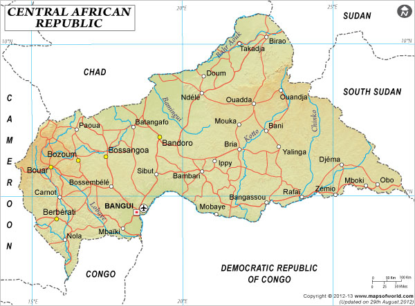
Central African Republic's latitude and longitude is 49° 45' N and 15° 30' E . Below is the map of Central African Republic showing major towns, roads, airports with latitudes and longitudes plotted on it.

Central African Republic Latitude and Longitude Map Chad Lat Long Map Cameroon Lat Long Map Congo Lat Long Map Gabon Lat Long Map Democratic Republic of Congo Latitude and Longitude Map South Sudan Latitude and Longitude Map Sudan Lat Long Map
Description : Find Central African Republic latitude and longitude map showing comprehensive details including cities, roads, towns, airports and much more. Disclaimer
×

Disclaimer  :  All efforts have been made to make this image accurate. However MapSherpa, Inc, its directors and employees do not own any responsibility for the correctness or authenticity of the same.


Search For Latitude & Longitude Map

By Country

Or

Latitude

Longitude

Or

Area

* Put South & West values with minus ( - ) sign.

The geographical alignment of Central African Republic indicates the latitude of 7° 00' N and longitude of 21° 00' E.

The specific latitude of the country suggests its proximity to the equator as well as its position in the northern hemisphere.This country is located towards the northern area of Democratic Republic of Congo.

Central African Republic occupies 622,984 square kilometers of area in the central region of Africa. The terra firma of this country is more or less a highland. A number of cliffs are dispersed through the northwestern and the south western regions of this country. The climatic condition of Central African Republic is specified as tropic weather which is featured by arid winter and warm and damp summers. Bangui, the capital of this country is with latitude of 4° 22' N and longitude of 18° 55' E. The difference of time observed here is UTC+1.

Latitude and Longitude of Central African Republic

LocationLatitudeLongitude
Bakouma05°40'N22°56'E
Bambari05°40'N20°35'E
Bangassou04°55'N23°07'E
Bangui04°23'N18°35'E
Berberati04°15'N15°40'E
Bomu04°40'N22°30'E
Bossangoa06°35'N17°30'E
Bour06°00'N15°40'E
Bozoum06°25'N16°35'E
Carnot04°59'N15°56'E
Djema06°03'N25°15'E
Ippy06°05'N21°07'E
 
LocationLatitudeLongitude
Kaga Bandoro07°00'N19°10'E
Mbaiki03°53'N18°01'E
Mobaye04°25'N21°05'E
Mopoi05°06'N26°54'E
Ndele08°25'N20°36'E
Nola 03°35'N16°04'E
Obo05°20'N26°32'E
Paoua07°09'N16°20'E
Rafai04°59'N23°58'E
Toussora Mt.9°7'N23°14'E
Yalinga6°33'N23°10'E
Zemio 5°2'N25°5'E

Last Updated on: November 9th, 2017