logo


Cambodia Latitude and Longitude Map

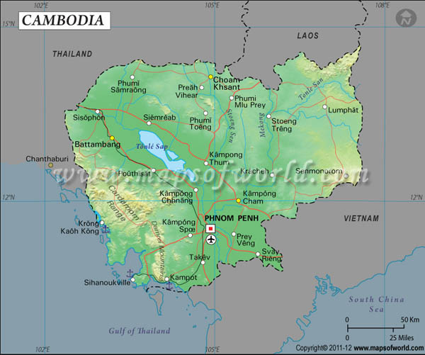
Cambodia's latitude and longitude is 13° 00' N and 105° 00' E . Below is the map of Cambodia showing major towns, roads, airports with latitudes and longitudes plotted on it.
Cambodia Latitude and Longitude Map Thailand Lat Long Map Laos Lat Long Map Vietnam Lat Long Map
Description: Find Cambodia latitude and longitude map showing comprehensive details including cities, roads, towns, airports and much more. Disclaimer
×

Disclaimer  :  All efforts have been made to make this image accurate. However MapSherpa, Inc, its directors and employees do not own any responsibility for the correctness or authenticity of the same.


Search For Latitude & Longitude Map

By Country

Or

Latitude

Longitude

Or

Area

* Put South & West values with minus ( - ) sign.

The geographic alignments of the country of Cambodia indicates 13° 00' N and 105° 00' E latitude and longitude respectively.
The latitude signifies Cambodia's location in the Northern Hemisphere. Cambodia is surrounding the Gulf of Thailand, which is situated among Laos, Thailand and the country of Vietnam.

Cambodia integrates 181,000 square kilometers of area in the southeastern Asia. The terra firma of Cambodia is characterized by plain lands which are primarily low. The climatic condition of Cambodia is considered as tropic. Two main seasons dominate Cambodia as semiarid season and rainy season. A slight temperature difference is observed with the change of seasons. The capital of Cambodia Phnom Penh, is a city with 11° 30 N of latitude and 104° 55 of longitude . Cambodia's variation of time indicates UTC+7.

Latitude and Longitude of Cambodia

LocationLatitudeLongitude
Angkor13°22'N103°50'E
Angtassom11°01'N104°41'E
Banam11°20'N105°17'E
Batdambang13°07'S103°12'E
Batheay11°59'N104°57'E
Battambang/Batdambang13°07'N103°12'E
Buong Long13°44'N106°59'E
Chamkar Luong11°00'N103°45'E
Cheom Ksan14°13'N104°56'E
Chhep13°45'N105°24'E
Chhlong12°15'N105°58'E
Chhuk10°46'N104°28'E
Chong Kai13°57'N103°35'E
Dak Dam12°20'N107°21'E
Damrei, Chuor Phnum11°30'N103°00'E
Kachot11°30'N103°03'E
Kampang Chhnang12°20'N104°35'E
Kampong Saom10°38'N103°30'E
Kampong Saom, Chaak10°50'N103°32'E
Kampot10°36'N104°10'E
Kep.10°29'N104°19'E
Khemarak Phouminville11°37'N102°59'E
Khong13°32'N105°58'E
Kompong Bang12°24'N104°40'E
Kompong Cham12°00'N105°30'E
Kompong Chhnang/Kampang Chhnang12°20'N104°35'E
Kompong Chikreng13°05'N104°18'E
Kompong Kleang13°06'N104°08'E
Kompong Luong11°49'N104°48'E
Kompong Pranak13°35'N104°55'E
Kompong Som/Kampong Saom10°38'N103°30'E
Kompong Som, Chhung/Kampong Saom, Chaak10°50'N103°32'E
Kompong Speu11°26'N104°32'E
Kompong Sralao14°05'N105°46'E
Kompong Thom12°35'N104°51'E
Kompong Trabeck13°06'N105°14'E
 
LocationLatitudeLongitude
Kompong Trabeck11°09'N105°28'E
Kompong Trach11°25'N105°48'E
Kompong Tralach11°54'N104°47'E
Kong/Khong13°32'N105°58'E
Kong, Koh11°20'N103°00'E
Koulen/Kulen13°50'N104°40'E
Kracheh12°32'N106°10'E
Krakor12°32'N104°12'E
Kralanh13°35'N103°25'E
Kratie/Kracheh12°32'N106°10'E
Kravanh, Chuor Phnum12°00'N103°32'E
Krong Kaoh Kong11°35'N103°00'E
Kulen13°50'N104°40'E
Leach12°21'N103°46'E
Lomphat13°30'N106°59'E
Melouprey 13°48'N105°16'W
Moung12°46'N103°27'E
Pailin12°46'N102°36'E
Phnom Penh11°33'N104°55'E
Phnum Penh/Phnom Penh11°33'N104°55'E
Pouthisat12°34'N103°50'W
Prey Veng. 11°35'N105°29'E
Pursat/Pouthisat12°34'N103°50'E
Ream10°34'N103°39'E
Rong Koh10°45'N103°15'E
Sambor 12°46'N106°0'E
Samrong 14°15'N103°30'E
San13°32'N105°57'E
Sandan/Sambor12°46'N106°0'E
Sen13°45'N105°12'E
Senmororom12°27'N107°12'E
Sisophon13°38'N102°59'E
Sre Ambel11°8'N103°46'E
Srepok13°33'N106°16'E
Tang Krasang 12°34'N105°3'E
Thalabarivat13°33'N105°57'E
Thmar Puok13°57'N103°4'E
Virachei 13°59'N106°49'E

Last Updated on: November 9th, 2017