The main
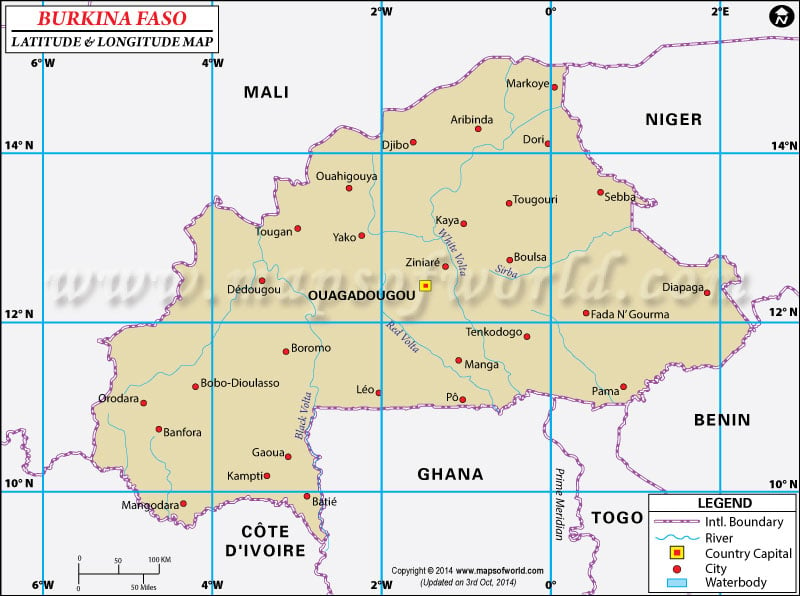
latitude and longitude of Burkina Faso is 13° North and 2° West.
Burkina latitude and longitude signifies two most important things about this West African country that it is very near to the zero degree longitude and latitude.
As this country is located between the Equator and the Tropic of Cancer the climatic condition of this country is temperate in kind with hot and wet summers and dry winters. The total area which falls between the first and last latitude and longitude of Burkina Faso is 274,200 square kilometer.
The
latitude and longitude of the capital city of Burkina Faso, Ouagadougou, is 12° 20'North and 1° 31'West. As the Burkina Faso longitudes are very close to the Prime Meridian the time followed in the country is same as the Greenwich Mean Time. The time zone is five hours ahead of the standard time of Washington DC.
Latitude and Longitude of Burkina Faso |
|---|
| Location | Latitude | Longitude |
|---|
| Bobo-Dioulasso | 11°08'N | 04°13'W |
| Fada-n-ourma | 12°10'N | 00°30'E |
| Gaoua | 10°20'N | 03°08'W |
| Kaya | 13°04'N | 01°10'W |
| Koudougou | 12°10'N | 02°20'W |
| Tougan | 13°11'N | 2°58'W |
Last Updated on: November 9th, 2017


