logo


Bolivia Latitude and Longitude Map

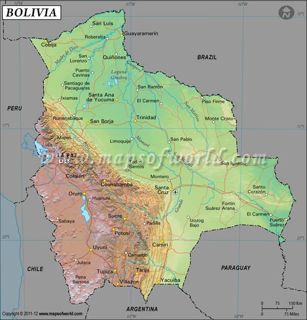
Bolivia's latitude and longitude is 17° 00' N and 65° 00' W . Below is the map of Bolivia showing major towns, roads, airports with latitudes and longitudes plotted on it.

Bolivia Latitude and Longitude Map Brazil Lat Long Map Paraguay Lat Long Map Argentina Lat Long Map Chile Lat Long Map Peru Lat Long Map
Description : Find Bolivia latitude and longitude map showing comprehensive details including cities, roads, towns, airports and much more. Disclaimer
×

Disclaimer  :  All efforts have been made to make this image accurate. However MapSherpa, Inc, its directors and employees do not own any responsibility for the correctness or authenticity of the same.


Search For Latitude & Longitude Map

By Country

Or

Latitude

Longitude

Or

Area

* Put South & West values with minus ( - ) sign.

The main latitude and longitude of Bolivia is 17° South and 65° West. This Latin American country falls in the southern hemisphere of the world.
The total area which falls within the first and last latitudes and longitudes of Bolivia is 1,098,580 square kilometers. As the country of Bolivia fall within the equator and the Tropic of Capricorn, the climate of the country is tropical and humid. But there is a significant difference in the temperature and climatic conditions in the area near the Andes mountain range.

The latitude and longitude of the largest city of Bolivia , Santa Cruz de la Sierra, is 17° 48' South and 68° 10' West. The latitudes and longitudes of Sucre and La Paz are 19° 2'South, 16° 15'West and 17° 48'South, 68° 8West respectively. As the longitude of Bolivia is on the west of the Prime Meridian the time zone runs four hours less than the UTC.


Latitude and Longitude of Bolivia

LocationLatitudeLongitude
Aiquile18°10'S65°10'W
Ancohuma, Nevada16°00'S68°50'W
Apolo14°30'S68°30'W
Beni10°23'S65°24'W
Boyuibe20°25'S63°17'W
Challapata18°53'S66°50'W
Charagua19°45'S63°10'W
Charana17°30'S69°25'W
Chiguana21°00'S67°58'W
Chorolque, Cerro20°59'S66°05'W
Cobija11°00'S68°50'W
Cochabamba17°26'S66°10'W
Coipasa, Salar de19°26'S68°09'W
Concepcion16°15'S62°08'W
Concepcion, L.17°20'S61°20'W
Corocoro17°15'S68°28'W
Corocico16°00'S67°50'W
Cotagaita20°45'S65°40'W
Cuevo20°15'S63°30'W
Cuzco20°00'S66°50'W
Desaguadero16°35'S69°05'W
El Cerro17°30'S61°40'W
Entre Rios21°30'S64°25'W
Exaltacion13°10'S65°20'W
Grande15°51'S64°39'W
Guaqui16°41'S68°54'W
Huanchaca20°15'S66°40'W
Ichilo15°57'S64°50'W
Illampu/Ancohuma, Nevada16°00'S66°50'W
Illimani, Nevado16°30'S67°50'W
Itonamas12°28'S64°24'W
Ixiamas13°50'S68°05'W
La Paz16°20'S68°10'W
Mdidi12°32'S66°52'W
Madre de Dios10°59'S66°08'W
Magdalena 13°13'S63°57'W
 
LocationLatitudeLongitude
Mamore10°23'S65°53'W
Mojo21°48'S65°33'W
Orton10°50'S67°0'W
Oruro18°0'S67°09'W
Pilaya 20°55'S64°04'W
Poopo L. de18°30'S67°35'W
Potosi19°38'S65°50'W
Puerto Heath 12°34'S68°39'W
Puerto Suarez18°58'S57°52'W
Pulacayo20°25'S66°41'W
Punata 17°32'S65°50'W
Riberalta11°0'S66°0'W
Rio Mulatos19°40'S66°50'W
Robore18°10'S59°45'W
Rogagua L. 13°43'S66°50'W
Rogaoguado L. 13°0'S65°30'W
Sairecabur Cerro 22°43'S67°54'W
Sajama 18°7'S69°0'W
Salar de Uyuni20°30'S67°45'W
San Lucas20°5'S65°7'W
San Martin13°8'S63°43'W
San Matias16°25'S58°20'W
San Pablo21°43'S66°38'W
Sanandita 21°40'S63°45'W
Santa Ana13°50'S65°40'W
Santa Cruz, 17°43'S63°10'W
Santa Rosa del Sara17°7'S63°35'W
Tupiza21°30'S65°40'W
Umala17°25'S68°5'W
Uncia18°25'S66°40'W
Uyuni20°28'S66°47'W
Viacha16°39'S68°18'W
Villa Bella 10°25'S65°22'W
Villa Montes21°10'S63°30'W
Villazon 22°0'S65°35'W

Last Updated on: November 9th, 2017