logo


Bangladesh Latitude and Longitude Map

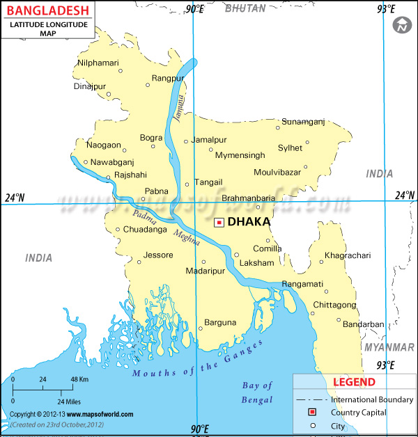
Bangladesh's latitude and longitude is 24° 00' N and 90° 00' E . Below is the map of Bangladesh showing major towns, roads, airports with latitudes and longitudes plotted on it.
Bangladesh Latitude and Longitude Map Bhutan Lat Long Map India Lat Long Map Myanmar Lat Long Map
Description : Bangladesh latitude and longitude map showing comprehensive details including cities, roads, towns, airports and much more. Disclaimer
×

Disclaimer  :  All efforts have been made to make this image accurate. However MapSherpa, Inc, its directors and employees do not own any responsibility for the correctness or authenticity of the same.


Search For Latitude & Longitude Map

By Country

Or

Latitude

Longitude

Or

Area

* Put South & West values with minus ( - ) sign.

Bangladesh, one of the major neighboring countries of India, sits in between 24° 00' North latitude and 90° 00' East longitude.
Dacca or Dhaka, which is the capital city of Bangladesh , is situated in slightly different latitude and longitudinal areas. Dacca's latitude and longitude is 23° 51' North and 90° 24' East respectively. Another major city of Bangladesh , named Chittagong is located in between 22° 21' North latitude and 91° 50' East longitude.

Bangladesh is situated within such a latitude and longitude that it has got a weather that is tropical in nature. During summer season the climate is very hot and humid. In fact Bangladesh has got a very wet type of weather . In winter the climate is cold with and dry. Bangladesh receives a very high amount of precipitation each year that amounts to more than 1,500 mm. But this country is also subject to the devastation of cyclone many times a year.


Latitude and Longitude of Afganistan

LocationLatitudeLongitude
Abdulpur24°15'N88°59'E
Amnura24°37'N88°25'E
Atrai24°07'N89°22'E
Balla24°10'N91°35'E
Barisal22°45'N90°20'E
Bhola22°45'N90°35'E
Bogra24°51'N89°22'E
Brahmanbaria23°58'N91°15'E
Chandpur23°08'N90°45'E
Chatmohar24°15'N89°15'E
Chittagong22°19'N91°48'E
Chittagong24°05'N91°00'E
Comilla23°28'N91°10'E
Cox's Bazar21°26'N91°59'E
Dacca / Dhaka23°.43'N90°26'E
Dacca / Dhaka24°25'N90°25'E
Dhaka23°43'N90°26'E
Dhaka24°25'N90°25'E
Dharla25°46'N89°42'E
Dighinala23°15'N92°05'E
Dinajpur25°33'N88°43'E
Dohazari22°10'N92°05'E
East Bengal24°00'N90°00'E
Faridpur23°15'N89°55'E
Ghaghat25°19'N89°38'E
Goalundo Ghat23°50'N89°47'E
 
LocationLatitudeLongitude
Haringhata22°00'N89°58'E
Hatia22°30'N91°05'E
Jaldhaka26°16'N89°16'E
Jamalpur24°52'N89°56'E
Jessore23°10'N89°10'E
Karnaphuli Res.22°40'N92°20'E
Kaunia25°46'N89°26'E
Khulna22°45'N89°34'E
Khulna22°25'N89°35'E
Kunga21°46'N89°30'E
Kurigram25°49'N89°39'E
Kushtia23°55'N89°05'E
Madaripur23°19'N90°15'E
Maijdi22°48'N91°10'E
Mymensingh 24°45'N90°24'E
Nagar24°27'N89°12'E
Narayanganj23°40'N90°33'E
Noakhali / Maijdi22°48'N91°10'E
Pabna24°01'N89°18'E
Patuakhali22°20'N90°25'E
Phulchari25°11'N89°37'E
Rajshahi 24°22'N88°39'E
Rajshahi 25°0'N89°0'E
Rangpur25°42'N89°22'E
Saidpur25°48'N89°0'E
Sylhet24°54'N91°52'E

Last Updated on: November 8th, 2017