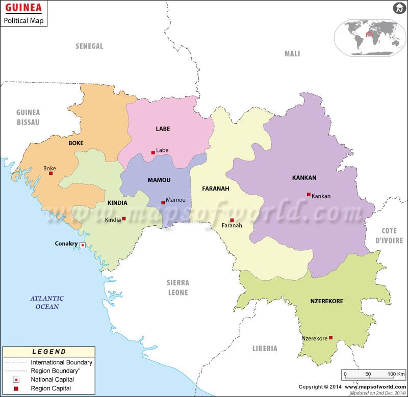
- Neighboring Countries - Sierra-Leone, Liberia, Cote d'Ivoire, Mali, Senegal, Guinea Bissau
- Continent And Regions - Africa Map
- Other Guinea Maps - Guinea Map, Where is Guinea, Guinea Blank Map, Guinea Road Map, Guinea Rail Map, Guinea River Map, Guinea Cities Map, Guinea Flag
French is the official language of Guinea, a country in West Africa. Guinea has a republic form of government. Guinea attained independence from France on 2nd October in the year 1958. The president of Guinea is the chief of the state and the Prime Minister is the head of the Guinea Government. In the political map of Guinea all the features of the country like the boundaries, and provinces are indicated.
Guinea Features
Guinea is a West African country. The country gained independence in the year 1958 from France. The climate of Guinea is generally humid and hot. Iron ore, bauxite, uranium, and gold are some of the natural resources of the country. In the political map of Guinea, the national capital, prefectures and their capitals, and both internal and international boundaries have been clearly marked by using specific symbols. The geographic coordinates of Guinea are 11° North latitude and 10° West longitude.
Guinea Prefectures Capitals
There are 34 prefectures in Guinea which are Boffa, Beyla, Coyah, Boke, Dalaba, Dabola, Dubreka, Dinguiraye, Forecariah, Faranah, Gaoual, Fria, Kankan, Gueckedou, Kindia, Kerouane, Koubia, Kissidougou, Kouroussa, Koundara, Lelouma, Labe, Macenta, Lola, Mamou, Mali, Nzerekore, Mandiana, Siguiri, Pita, Tougue, Telimele, Yomou and capital Conakry which is a special city with a single region and prefecture government.
The national capital of Guinea is Conakry. It is the largest city and also the economic, and administrative hub of the country. There is a port in the capital city, which is also one of the major sources of employment and economy in the country. Guinea National Museum, Conakry Grand Mosque, and Polytechnic Institute of Conakry are located in the national capital. In the printable map of Guinea, the capital city has been highlighted by using a red star. The geographic coordinates of Conakry are 9° 30′ 33″ North latitude and 13° 42′ 44″ West longitude. The airports that are located in close proximity to Conakry are:
- Fria
- Conakry
- Freetown Lungi
Guinea Boundaries
The neighboring countries and seas surrounding the country are indicated prominently in the printable map of Guinea. The North Atlantic Ocean is on the western side of the country. The countries that are neighbors to Guinea are:
- Liberia to the south
- Cote D’ Ivore to the south-east
- Sierra Leone to the west of southeastern Guinea
- Guinea Bissau to north
- Mali to the northeast and north
- Senegal to the northern side
Guinea Cities
Some of the major cities of Guinea are indicated on the political map by black dots. The Guinea cities that are printed on the map are:
- Soukourala
- Koumbia
- Niagassola
- Sangaredi
- Timbo
| Prefecture | Population | Area(km.²) | Area(mi.²) |
|---|---|---|---|
| Beyla | 167,461 | 17,452 | 6,738 |
| Boffa | 156,949 | 9,100 | 3,514 |
| Boke | 294,314 | 11,053 | 4,268 |
| Conakry | 1,094,075 | 308 | 119 |
| Coyah | 85,106 | 2,166 | 836 |
| Dabola | 110,965 | 5,508 | 2,127 |
| Dalaba | 136,947 | 4,400 | 1,699 |
| Dinguiraye | 137,138 | 14,500 | 5,598 |
| Dubreka | 131,750 | 5,676 | 2,192 |
| Faranah | 147,743 | 13,000 | 5,019 |
| Forecariah | 201,193 | 4,200 | 1,622 |
| Fria | 80,903 | 1,811 | 699 |
| Gaoual | 137,599 | 11,500 | 4,440 |
| Gueckedou | 348,053 | 4,400 | 1,699 |
| Kankan | 262,567 | 11,564 | 4,465 |
| Kerouane | 153,913 | 9,750 | 3,764 |
| Kindia | 288,007 | 9,115 | 3,519 |
| Kissidougou | 205,836 | 8,872 | 3,425 |
| Koubia | 91,889 | 2,800 | 1,081 |
| Koundara | 90,919 | 5,505 | 2,125 |
| Kouroussa | 149,325 | 16,220 | 6,263 |
| Labe | 251,504 | 3,014 | 1,164 |
| Lelouma | 136,643 | 2,140 | 826 |
| Lola | 134,649 | 3,940 | 1,521 |
| Macenta | 281,053 | 8,600 | 3,320 |
| Mali | 211,190 | 9,790 | 3,780 |
| Mamou | 236,125 | 8,000 | 3,089 |
| Mandiana | 170,881 | 12,300 | 4,749 |
| Nzerekore | 282,903 | 4,625 | 1,786 |
| Pita | 238,760 | 4,320 | 1,668 |
| Siguiri | 271,594 | 15,500 | 5,985 |
| Telimele | 227,714 | 9,000 | 3,475 |
| Tougue | 114,377 | 6,400 | 2,471 |
| Yomou | 135,215 | 6,000 | 2,317 |
| 34 prefectures | 7,164,893 | 245,857 | 94,926 |

 Facts about Guinea