- Neighboring Countries - Equatorial Guinea, Cameroon, Republic of the Congo, Sao Tome Principe, Democratic Republic of the Congo
- Continent And Regions - Africa Map
- Other Gabon Maps - Gabon Map, Where is Gabon, Gabon Blank Map, Gabon Road Map, Gabon Rail Map, Gabon River Map, Gabon Cities Map, Gabon Political Map
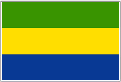
The national flag of the Gabonese Republic comprises three horizontal stripes of green (top), and yellow (middle), followed by a blue stripe.
The green band represents the natural resources found in the forests of Gabon; the yellow color in the flag represents the equator that passes through Gabon and also symbolizes the minerals, especially gold found in Gabon. The yellow stripe may also be interpreted as the bright and warm sunshine that the country experiences. Blue represents the clear, pristine waters of the Atlantic shore.
Gabon was originally an overseas territory of France and the country adopted its indigenous flag when the country gained independence from French rule, on August 17, 1960.
The present flag was designed in 1959 but at the time the French tricolor was imposed on the flag. This was later removed after independence.
| Official Name: | Gabonese Republic |
| Flag Proportion: | 3:4 |
| Designed by: | Louis Muhlemann |
| Location: | Located in Central Africa; Bordered by Equatorial Guinea, Cameroon, and the Republic of the Congo |
| Capital City: | Libreville |
| Major Cities: | Estuaire, Nyanga, Ngounie |
| Area: | 103,347 square miles |
| Population: | 22.3 lakhs as 2020 estimate |
| Currency: | Central African Franc (XAF) |
| Official Language: | French |
| National Anthem: | The Concord |
| National symbol(s): | black panther |
| National colors: | green, yellow, blue |
| National anthem: | |
| Name: | “La Concorde” (The Concorde) |
| Lyrics/Music: | Georges Aleka DAMAS |
Fact about the Gabon flag |
| Country | Gabon |
|---|---|
| Designed by | NA |
| Adopted | August 9, 1960 |
| Revision | 1990 |
| Design and Colors | A horizontal triband of green, gold and blue |
| Size Ratio | 3:4 |


 Gabon Independence Day