- Continent And Regions - Oceania Map
- Other Cook Islands Maps - Cook Islands Map, Where is Cook Islands
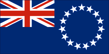
The official flag of the Cook Islands is a blue ensign and bears the Union Flag in the top left corner. On the right side of the flag are fifteen white stars forming a circle. The stars form a symmetrical ring and are all of equal size.
The Union Flag represents the nation’s historic ties to the United Kingdom and to the Commonwealth of Nations.
The fifteen stars in the flag represent the fifteen Cook Islands – Aitu, Aitutaki, Manihiki, Manuae, Mangaia, Mauke, Mitiaro, Nassau, Palmerston, Pukapuka, Tongareva, Rakahanga, Rarotonga, Suwarrow, and Takutea. The blue field symbolizes the Pacific Ocean, and the ideal of peace as cherished by the inhabitants.
| Official Name: | Cook Islands |
| Flag Proportion: | 1:2 |
| Adopted on: | August 4, 1979 |
| Location: | Located in the South Pacific Ocean |
| Capital City: | Avarua |
| Major Cities: | Mangaia, Rakahanga, Aitutaki |
| Area: | 91 square miles |
| Population: | 19,569 |
| Currency: | New Zealand Dollar (NZD), Cook Islands Dollar |
| Official Languages: | English, Cook Islands Maori |
| National Anthem: | God is Truth |
| National symbol(s): | a circle of 15, five-pointed, white stars on a blue field, Tiare maori (Gardenia taitensis) flower |
| National colors: | blue, white |
| National anthem: | |
| Name: | “Te Atua Mou E” (To God Almighty) |
| Lyrics/Music: | Tepaeru Te RITO/Thomas DAVIS |
Fact about Cook Islands flag |
| Country | Cook Islands |
|---|---|
| Designed by | NA |
| Adopted | August 4, 1979 |
| Revision | NA |
| Design and Colors | Blue ensign with a ring of fifteen white stars in the fly. |
| Size Ratio | 1:2 |

 Facts about Cook Islands