- Neighbouring Countries - Colombia, Peru
- Continent And Regional Maps - South America Map, Americas Map
- Other Ecuador Maps - Ecuador Map, Where is Ecuador, Ecuador Blank Map, Ecuador Railway Map, Ecuador Road Map, Ecuador River Map, Ecuador Physical Map, Ecuador Flag
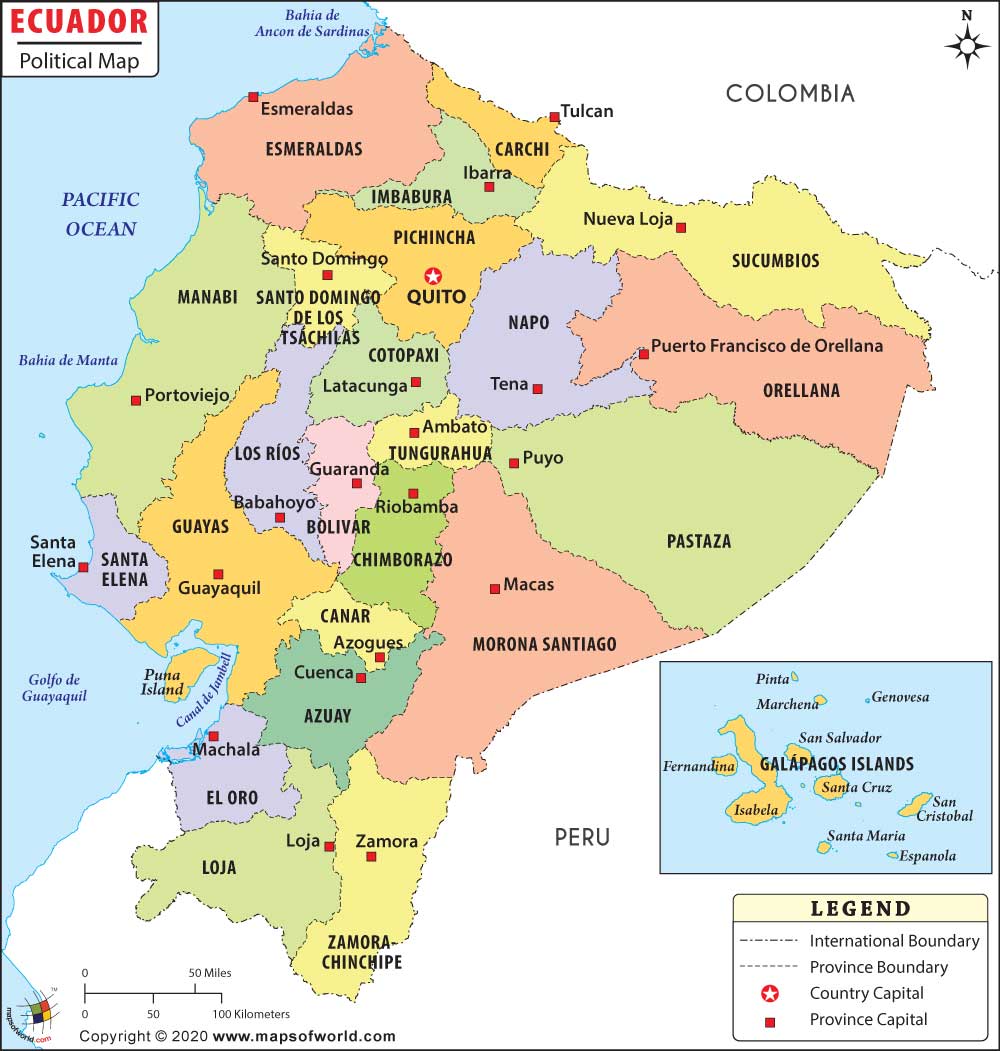
Ecuador Political Map presents an overview of the political provinces, province capitals, international boundary, important cities and capital of the country. This user friendly map can be considered as a one stop source for any information on Ecuador.
The Political Map of Ecuador
Ecuador follows a republic form of government and houses 22 provinces within its geographical limits. The legal procedures of Ecuador are carried on by following the rules and parameters of civil law. The President leads the government and serves as the chief of the state. The political map of Ecuador shows all the provinces having considerable significance. The province capitals also play an important role in the political framework of Ecuador. Hence, the political map also highlights the capitals of provinces. Peru and Columbia, both of which forms the international boundary, are prominently depicted in this map of Ecuador. A printable Ecuador political map is also available from the concerned website.
Provinces of Ecuador in the Political Map
There are a total of 22 administrative provinces in Ecuador. The political map of Ecuador covers both the provinces as well as the province capitals. Some of the provinces and their respective capitals indicated in the Ecuador political map are as follows:
| Morona Santiago – Macas | Guayas – Guayaquil | Manabi – Portoviejo |
| Pastaza – Puyo | Canar – Azogues | Loja – loja |
| Napo – Tena | Carchi – Tulcan | Esmaraldas – Esmaraldas |
| Sucumbios – Nueva Loja | Zamora-Chinchipe – Zamora | Imbabura – Ibarra |
| Azuay – Cuenca | Chimbdrazo – Riobamba | Los Rios – Babahoyo |
| Tungurahua – Ambato | El Oro – Machala |
Capital of Ecuador
The capital of Ecuador is Quito. Being the capital city Quito is served by many domestic and international airports. Some of the air teminals situated near Quito are:
- Mariscal Sucre international
- Cotopaxi International
- Atahualpa
- Santo Domingo Los Colorados
The coordinates of Quito are 78° 30′ West longitude and 0° 13′ South latitude. The towns and cities in the nearby locations of Quito include Hacienda San Juanito, Alfaro, La Foresta, Guapulo, Hacienda Monjas, Hacienda Maria, Hacienda Chaupi, Hacienda Verdecruz, Hacienda Villaflores and Hacienda San Antonio.
Some of the cities highlighted in the Ecuador political map include Paseja, Gualaquiza, Macara, Manta, Baeza, Chona and Zaruma, among others.
| Name | Population: 2001-11-25 census. | Area(km.²) | Area(mi.²) | Capital |
|---|---|---|---|---|
| Azuay | 599,546 | 8,125 | 3,137 | Cuenca |
| Bolivar | 169,370 | 3,940 | 1,521 | Guaranda |
| Canar | 206,981 | 3,122 | 1,205 | Azogues |
| Carchi | 152,939 | 3,605 | 1,392 | Tulcan |
| Chimborazo | 403,632 | 6,569 | 2,536 | Riobamba |
| Cotopaxi | 349,540 | 6,072 | 2,344 | Latacunga |
| El Oro | 525,763 | 5,850 | 2,259 | Machala |
| Esmeraldas | 385,223 | 15,239 | 5,884 | Esmeraldas |
| Galapagos | 18,640 | 8,010 | 3,093 | Puerto Baquerizo Moreno |
| Guayas | 3,070,145 | 16,740 | 6,463 | Guayaquil |
| Imbabura | 344,044 | 4,559 | 1,760 | Ibarra |
| Loja | 404,835 | 11,027 | 4,258 | Loja |
| Los Rios | 650,178 | 7,175 | 2,770 | Babahoyo |
| Manabi | 1,186,025 | 18,879 | 7,289 | Portoviejo |
| Morona-Santiago | 115,412 | 25,690 | 9,919 | Macas |
| Napo | 79,139 | 11,431 | 4,401 | Tena |
| Orellana | 86,493 | 22,500 | 8,700 | Puerto Francisco de Orellana |
| Pastaza | 61,779 | 29,774 | 11,496 | Puyo |
| Pichincha | 2,101,799 | 9,110 | 3,517 | Quito |
| Santa Elena | 238,889 | 3,763 | 1,453 | Santa Elena |
| Santo Domingo de los Tsachilas | 287,018 | 3,805 | 1,469 | Santo Domingo de los Colorados |
| Sucumbios | 128,995 | 18,328 | 7,076 | Nueva Loja |
| Tungurahua | 441,034 | 3,335 | 1,288 | Ambato |
| Zamora-Chinchipe | 76,601 | 23,111 | 8,923 | Zamora |
| 24 provinces | 12,084,020 | 272,048 | 105,038 |

 Ecuador Independence Day