British Columbia
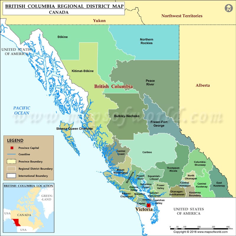
The map shows the various districts located in the Canadian province of British Columbia. The regional district boundary, boundary of the province, and international boundary are also shown on the map. Victoria, the capital of the province, is also demarcated on the map.
Check Area Codes of British Columbia here.
List of Regional Districts of British Columbia |
|---|
| Name | Div. | Population (2016) | Area (sq miles) | Head office location |
|---|---|---|---|---|
| Alberni-Clayoquot | 1 | 30,981 | 2,544 | Port Alberni |
| Bulkley-Nechako | 2 | 37,896 | 28,325 | Burns Lake |
| Capital | 3 | 383,360 | 903 | Victoria |
| Cariboo | 4 | 61,988 | 31,123 | Williams Lake |
| Central Coast | 5 | 3,319 | 9,456 | Bella Coola |
| Central Kootenay | 6 | 59,517 | 8,531 | Nelson |
| Central Okanagan | 7 | 194,882 | 1,122 | Kelowna |
| Columbia-Shuswap | 8 | 51,366 | 11,170 | Salmon Arm |
| Comox Valley | 9 | 66,527 | 657 | Courtenay |
| Cowichan Valley | 10 | 83,739 | 1,342 | Duncan |
| East Kootenay | 11 | 60,439 | 10,634 | Cranbrook |
| Fraser Valley | 12 | 295,934 | 5,149 | Chilliwack |
| Fraser-Fort George | 13 | 94,506 | 19,566 | Prince George |
| Metro Vancouver | 14 | 2,463,431 | 1,113 | Burnaby |
| Kitimat-Stikine | 15 | 37,367 | 40,333 | Terrace |
| Kootenay Boundary | 16 | 31,447 | 3,120 | Trail |
| Mount Waddington | 17 | 11,035 | 7,816 | Port McNeill |
| Nanaimo | 18 | 155,698 | 787 | Nanaimo |
| North Okanagan | 19 | 84,354 | 2,897 | Coldstream |
| Northern Rockies | 20 | 5,393 | 32,862 | Fort Nelson |
| Okanagan-Similkameen | 21 | 83,022 | 4,021 | Penticton |
| Peace River | 22 | 62,942 | 45,325 | Dawson Creek |
| Powell River | 23 | 20,070 | 1,959 | Powell River |
| North Coast | 24 | 18,133 | 7,637 | Prince Rupert |
| Squamish-Lillooet | 25 | 42,665 | 6,297 | Pemberton |
| Stikine Region | 26 | 740 | 45,816 | (n/a) |
| Strathcona | 27 | 44,671 | 7,057 | Campbell River |
| Sunshine Coast | 28 | 29,970 | 1,458 | Sechelt |
| Thompson-Nicola | 29 | 132,663 | 17,161 | Kamloops |
 Wall Maps