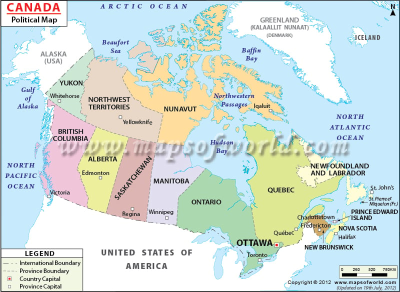
- Canada Provinces and Territories - Alberta, British Columbia, Manitoba, New Brunswick, Newfoundland and Labrador, Northwest Territories, Nova Scotia, Nunavut, Ontario, Prince Edward Island, Quebec, Saskatchewan, Yukon
- Neighboring Countries - Greenland, United States, Iceland
- Continent And Regions - North America Map, Americas Map
- Other Canada Maps - Canada Map, Where is Canada, Canada Blank Map, Canada Road Map, Canada Rail Map, Canada River Map, Canada Cities Map, Canada Physical Map, Canada Flag, Country with the Longest Coastline
Canada is bordered by the United States to the south and northwest, with Alaska, separated from the rest of the United States.
The border that Canada shares with the United States is the longest land border in the world between just two countries. Canada is comprised of ten provinces and three territories.
Major Cities in Canada:
- Ottawa
- Toronto
- Montreal
- Edmonton
- Vancouver
- Calgary
- Halifax
- Victoria
- Winnipeg
Canada’s capital is Ottawa, located on the south bank of the Ottawa River in southeastern Ontario. With a population of 812,129, it is the fourth largest city in the country. Not far from Ottawa, Toronto is the largest city in Canada. It has an estimated population of 2,503,281.
Provinces of Canada |
|---|
| Provinces | Capital | Area(km.²) | Area(mi.²) |
|---|---|---|---|
| Alberta | Edmonton | 661,848 | 255,541 |
| British Columbia | Victoria | 944,735 | 364,764 |
| Manitoba | Winnipeg | 647,797 | 250,116 |
| New Brunswick | Fredericton | 72,908 | 28,150 |
| Newfoundland and Labrador | Saint John’s | 405,212 | 156,453 |
| Nova Scotia | Halifax | 55,284 | 21,345 |
| Ontario | Toronto | 1,076,395 | 415,598 |
| Prince Edward Island | Charlottetown | 5,660 | 2,185 |
| Québec | Quebec | 1,542,056 | 595,391 |
| Saskatchewan | Regina | 651,036 | 251,366 |
