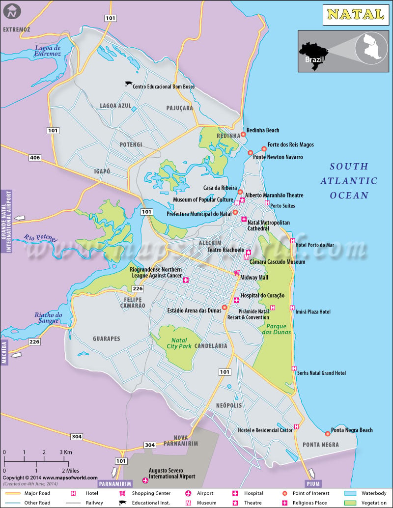
Natal, the capital and largest city of Rio Grande do Norte state, is located in northeastern Brazil. The capital city of Brazil is located 1516 miles southwest of Natal. Home to the second largest urban park in Brazil, Natal lies on the Atlantic coast. It is known for lovely beaches, historical monuments, and off-season carnival. The older part of Natal is just 7.5 miles (12 km) northwest of Ponta Negra beach.
Natal Map
This colorful map of Natal shows the major roads and railway routes in the city. From the Redinha Beach in the north to Ponta Negra beach on southeast, major attractions in Natal are depicted. The Augusto Severo International Airport on the southwest Natal and the popular hotels in Natal are shown on the map. This is an ideal tourist map that covers Museum of Popular Culture, Alberto Maranhao Theatre and shopping centers such as Midway Mall in central Natal. The Natal City Park in south and Parque das Dunas on east are also shown on this Natal map. In case you want to know what all otels are there in your vicinity, this thematic map on hotels in Natal will be of help.
Natal Attractions
- The southern part of Natal is the most affluent area where most tourists prefer to stay. Apart from Ponta Negra beach, upscale hotels, restaurants and shopping malls are located here.
- Natal’s Historical Center is in the east. It is home to Forte dos Reis Magos and Ponte de Todos.
- The industrial zone in northern Natal is home to the Redinha beach that offers nice views of the city.
Things to do in Natal
Once you have the tourist map of Natal with you, you can start exploring activities in and around the city.
- Take a buggy ride: Go on a vertical drive along the coast, both North and Southward.
- Watch the sunset: Watch the sun g down the horizon from the banks of the Potengi River. The best location is near the Army base. You can also go for a boat cruise at the river to watch the sunset.
- Attend Forró com Turista: This Thursday party is where you can learn to dance forró, a popular musical style.
Nearest Cities
- Joao Pessoa – 153 km
- Campina Grande – 176 km
- Paulista – 243 km
- Mossoro – 244 km
- Olinda – 252 km
Rio de Janiero, which hosts the 2016 Rio Olympics, is 1619 miles southwest from Natal.
How to reach Natal?
By Air: The Augusto Severo International Airport, located about 16 miles (26 km) from downtown Natal, is served by direct flights from important Brazilian cities, including São Paulo, Rio de Janeiro, Salvador, and Brasilia. There are direct flights to international destinations such as Lisbon and Milan.
By Road: Intercity buses from Fortaleza, Recife, and João Pessoa connect the city of Natal. The bus station is about 2 miles southwest of the city center, and 3 miles northwest of the Ponta Negra beach.
