- Neighboring Countries - Niger, Nigeria, Togo, Burkina Faso
- Continent And Regions - Africa Map
- Other Benin Maps - Benin Map, Where is Benin, Benin Blank Map, Benin Road Map, Benin Rail Map, Benin Cities Map, Benin Physical Map, Benin Flag
The Republic of Benin is a country located in West Africa. It covers an area of 43,484 square miles and has an estimated population of 8,791,832.
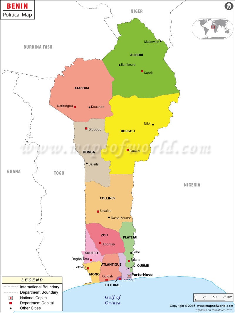
The Benin Political Map shows the exact location of the country. Located in West Africa, Benin shares its borders with Togo to the west, Nigeria to the east, Bight of Benin to the south, and Burkina Faso and Niger to the north.
The national capital, Porto-Novo is indicated on the map with a red circle enclosed in a square. It is located in the south-eastern region of the Republic of Benin. The total area covered by the capital city is 42.5 square miles.
The largest city of Benin is Cotonou with an estimated population of 761,137. Check other Benin Cities here.
The Benin Political Map also shows the major cities, departments, and other political divisions of the country. The major cities of Benin shown in the map are: Djougou, Banikoara, Bohicon, Cove, Dassa-Zoume, Save, Savalou, Tanguieta, Kouande, and Lokossa.
Benin is divided into twelve departments that are sub-divided into seventy-seven communes. The departments are:
- Alibori
- Atakora
- Atlantique
- Borgou
- Collines
- Donga
- Kouffo
- Littoral
- Mono
- Oueme
- Plateau
- Zou
Benin is a presidential representative democratic republic. The president is both the head of the state and the head of government. Yayi Boni is the current President of Benin. Pascal Koupaki is the Prime Minister of the nation.
Benin achieved independence from France on August 1, 1960.
| Department | Population | Area(km.²) | Area(mi.²) | Capital |
|---|---|---|---|---|
| Alibori | 521,093 | 25,683 | 9,916 | Kandi |
| Atacora | 549,417 | 20,459 | 7,899 | Natitingou |
| Atlantique | 801,683 | 3,233 | 1,248 | Ouidah |
| Borgou | 724,171 | 25,310 | 9,772 | Parakou |
| Collines | 535,923 | 13,561 | 5,236 | Savalou |
| Couffo | 524,586 | 2,404 | 928 | Dogbo |
| Donga | 350,062 | 10,691 | 4,128 | Djougou |
| Littoral | 665,100 | 79 | 31 | Cotonou |
| Mono | 360,037 | 1,396 | 539 | Lokossa |
| Oueme | 730,772 | 2,835 | 1,095 | Porto-Novo |
| Plateau | 407,116 | 1,865 | 720 | Sakete |
| Zou | 599,954 | 5,106 | 1,971 | Abomey |
| 12 departments | 6,769,914 | 112,622 | 43,484 |
Note: Population: 2002-02-11 census (source [1]).

 Benin Science and Technology