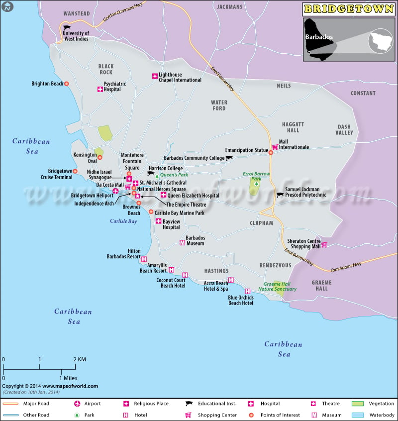
Facts About Bridgetown |
|
|---|---|
| Country | Barbados |
| State | Saint Michael, Barbados |
| Founded | 1628 |
| Area | 40 km2 |
| Population | 98511 estimate |
| Lat Long Bridgetown | 13°06′21″N 59°36′47″W |
| Time Zone | UTC/GMT -4 |
| Area Code | +1 246 |
| Language | English |
| Major Religion | Christian |
| Point of interest | National Heroes Square mountain Garden, Parliament Building, Independence Square and The Independence Arch, The Montefiore Fountain, Parliament Buildings of Barbados, The Cathedral Church of Saint Michael and All Angels, The St. Mary’s Anglican Church, The St. Patrick’s Roman Catholic Cathedral, The Jewish Synagogue, The Pelican Village and Craft Centre, Queen’s Park, The Lord Nelson Statue, The Barbados Museum, Kensington Oval, Carlisle Bay Beach, Cheapside market, The Tom Adams Financial Complex, The Frank Collymore Hall of the Performing Arts, The Cathedral Plaza, The Cave Shepherd Department Store (No.10 Broad Street), The Mutual Building (lower Broad Street), The Cheapside Gardens, Sagicor Plaza, The Garrison Savannah and National Historic Area, The Hilton Hotel, Martineau House, Pierhead Development Complex, Nelson Statue |
About city :
Bridgetown is the capital of Barbados – the easternmost island in the Caribbean. It is the largest city and the commercial center of the country. This city has also been declared a World Heritage site by UNESCO on 25th June 2011. The island was almost uninhabited when the British landed there. Research suggests that the area was once occupied by the Arawak Indians who were driven away to another island by an attack from another tribe. The only sign of this Indian occupation was the rude bridge they had constructed over the swamp in the Careenage area. Initially named Indian Bridge, the city, later on, came to be known as the town of St. Michael in official documents. Later, the name Bridgetown was given to this city. Barbados won independence on 30th November 1966 and Bridgetown became the capital.
The city today covers an area of 40 sq km and has an approximate population of 98,511.
Geography :
The area of Bridgetown was originally occupied by a swamp. This swamp was later drained and in its place, the settlement came up. The Constitution River also known as the Careenage passes through this area, which has enabled pleasure crafts to pass through the heart of the city. Moreover, the river drains to Carlisle Bay located southwest of the island.
Bridgetown enjoys a tropical wet-dry type of climate. It is warm throughout the year though the Trade winds from the sea manage to lower the temperature a little. June to January are the wet months while the remaining months are comparatively drier.
How to reach (transport) :
In order to travel to Bridgetown, you will first have to arrive at the Barbados airport. The Grantley Adams International airport is one of the leading airports in the Caribbean and is located about 13 km from Bridgetown. From there you can travel to Bridgetown by taxi or avail of the excellent bus service. Very well-organized bus service is available to designated terminals within the city.
When to visit :
The best time to visit Bridgetown, Barbados is January, February, and March. These are the slightly drier months of the year when you can enjoy your vacations.
Culture (fairs and festivals) and traditions :
The culture of Bridgetown shows a number of different influences. Most of the people living here are of African origin. So, the African influence is clearly seen. However, it had been a colony of the British for 300 years. So, the British influence is inevitable. Today, it is a bustling center of trade and a popular tourist destination for people all over the world. Bridgetown has now acquired a cosmopolitan polish in addition to its strong local flavor.
Several festivals are celebrated in Bridgetown. Crop over was traditionally celebrated to mark the end of the sugar harvesting season. The festival is celebrated all over the country including its capital and thousands of people visit the islands at this time. You can stroll through the markets of Bridgetown; enjoy traditional music like calypso and soca and cuisine. Excellent examples of local art and craft can be bought here. A huge parade marks the end of the festival.
The annual food and wine festival are also celebrated during November in Bridgetown when celebrated chefs are invited from all over the world to present their culinary art to the people of Barbados.
Independence Day is also celebrated in November with lots of songs and celebrations.
Points of interest (places to visit) :
In addition to the beautiful scenery and the charming cityscape, there are quite a few beautiful places to see in Bridgetown, Barbados.
- The Careenage is one of the most beautiful sights of Bridgetown, Barbados. This is a marina for pleasure crafts and yachts. It is surrounded by beautiful esplanades, pathways, and benches for pedestrians. A stroll around the Careenage is something that you must do in Bridgetown, Barbados.
- The National Hero’s square is another landmark of Bridgetown. This triangular plaza is marked by the statue of Admiral Nelson and a war memorial.
- The Barbados museum is an excellent place to visit if you want to understand the history and culture of the Barbados islands.
- You can also visit the neo-gothic parliament building which is open to the public when parliament is in session.
Accommodation :
A comfortable place to stay is essential in order to enjoy your holiday. However, hotels are scarce in Bridgetown proper. Most of the luxury hotels are located on beautiful beaches at some distance from Bridgetown. However, you can check out the Hilton Bridgetown or the Courtyard Bridgetown if you want to stay in the city itself.

 Barbados Facts