- Armenia Cities - Yerevan
- Neighboring Countries - Azerbaijan, Georgia, Turkey, Iran
- Continent And Regions - Asia Map
- Other Armenia Maps - Armenia Map, Where is Armenia, Armenia Blank Map, Armenia Road Map, Armenia River Map, Armenia Physical Map, Armenia Flag
The Republic of Armenia is a landlocked country located at the crossroads of Eastern Europe and Western Asia. It covers an area of 11,484 square miles. The country has an estimated population of 3,262,200.
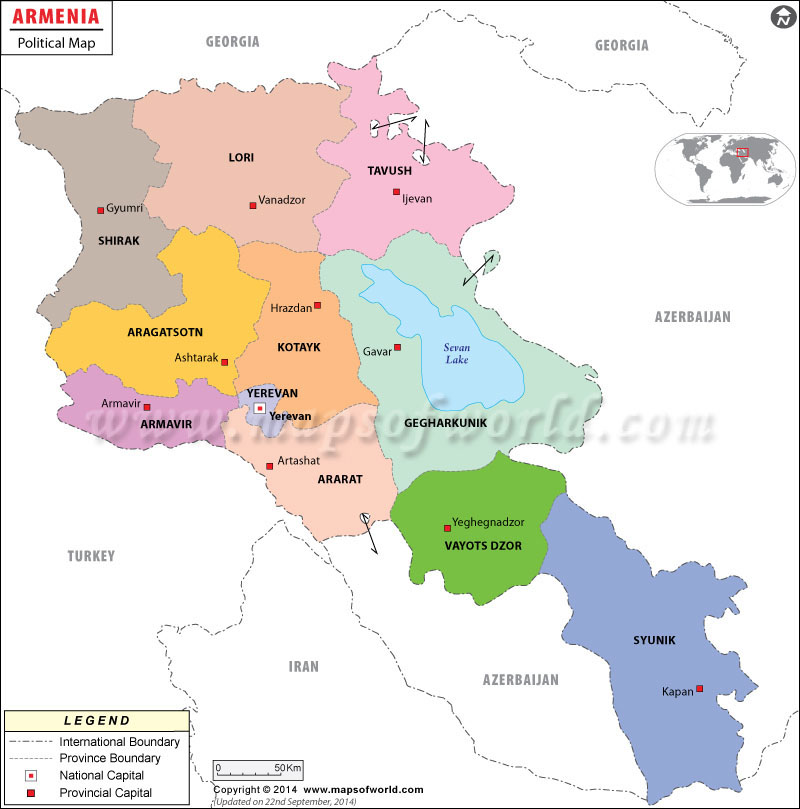
The political map of Armenia highlights the major provinces and their capitals, the national and international boundaries, and the other political divisions of the country. Besides, it also features the various countries surrounding Armenia.
As shown in the map, the Republic of Armenia shares its borders with Turkey to the west, Georgia to the north, Nagorno-Karabakh Republic and Azerbaijan to the east, and Iran and the Azerbaijani exclave of Nakhchivan to the south.
Yerevan is the capital city of Armenia and is presented on the map with a red square. It is important administrative, cultural, and industrial center of the country and is also the largest city; Yerevan has a total area of 115.8 square miles.
Some of the major cities of Armenia are: Vanadzor, Gyumri, Abovyan, Sevan, Sisian, Goris, Spitak, Armavir, and Gavar.
Armenia is a presidential representative democratic republic. The President is the head of government; Serzh Sargsyan is the current and the third President of Armenia and Tigran Sargsyan is the current Prime Minister.
The country declared its independence from Soviet Union on August 23, 1990, and on September 21,1991, it was recognized as an independent country.
| Province | Population | Area(km.²) | Area(mi.²) | Capital |
|---|---|---|---|---|
| Aragacot’n | 126,278 | 2,755 | 1,064 | Ashtarak |
| Ararat | 252,665 | 2,003 | 773 | Artashat |
| Armavir | 255,861 | 1,241 | 479 | Armavir |
| Erevan | 1,091,235 | 210 | 81 | Erevan |
| Gelark’unik’ | 215,371 | 3,655 | 1,411 | Gavar (Kamo) |
| Kotayk’ | 241,337 | 2,100 | 810 | Razdan |
| Loṙi | 253,351 | 3,791 | 1,464 | Vanadzor (Kirovakan) |
| Sirak | 257,242 | 2,679 | 1,034 | Gyumri (Leninakan) |
| Syunik | 134,061 | 4,505 | 1,739 | Kafan |
| Tavus | 121,963 | 3,120 | 1,205 | Idjevan |
| Vayoc’Jor | 53,230 | 2,406 | 929 | Yegheknadzor |

 Population of Armenia