What State Borders the Most States?

The United States comprises 50 states, with 48 of them being contiguous. Alaska occupies the northwest extremity of North America, while Hawaii lies in Oceania. As these two states are not part of the mainland US, they do not share borders with any other state in the country. In this article, we will know what State borders the most states? and more.
States with the Most Shared Borders
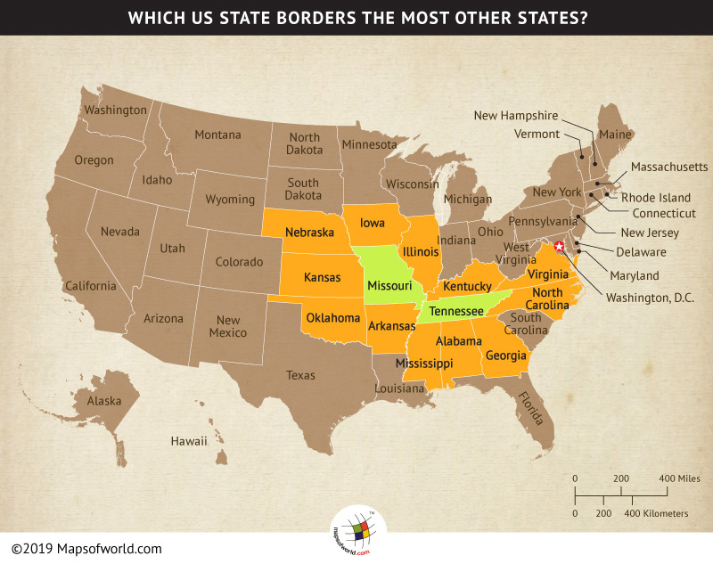
There are two states Tennessee and Missouri, which share their borders with the maximum number of states. Both of these states share their borders with eight other states and also with each other.
States that Border Tennessee
Tennessee is a big state, but not the biggest, ranking number 36 in size and covers an area of 42,143 square miles. It touches eight other states around it, to the north, there’s Kentucky and Virginia. Moving east, we have North Carolina. Down south, Tennessee borders Georgia, Alabama, and Mississippi. And finally, on the west side, the Mississippi River separates Tennessee from Arkansas and Missouri. The Tennessee border not only shows where the state ends but also, tells a story about the state.
States that Border Missouri
Missouri is in the middle of the United States, covers an area of 69,715 square miles, and ranks 21st in land area. Apart from its neighbor Tennessee, Kentucky, and Illinois, are also located on the eastern side across the Mississippi River and Nebraska lies to the west of Missouri. On the north is Iowa, and Arkansas, Kansas, and Oklahoma on the south.
Interesting Border Facts
- Four Corners Monument is the only place in the United States where the borders of four states come together: Arizona, Colorado, New Mexico, and Utah. You can actually stand in all four states at the same time.
- The longest straight-line border between two states is the border between Nevada and Utah. It is about 400 miles long.
- The Mississippi River creates the longest river border between states. It separates ten states: Minnesota, Wisconsin, Iowa, Illinois, Missouri, Kentucky, Tennessee, Arkansas, Mississippi, and Louisiana.
- Pennsylvania and Delaware have the shortest land border between any two states, measuring only about 1 mile long.
- Kansas City is a unique major city that sits in both Kansas and Missouri. This means you can cross the state line without leaving the city.
List of US States and their Borders
Here’s a list of each US state and the states they share borders with. This list details which states share land or water borders.
- Alabama: Tennessee, Georgia, Florida, Mississippi
- Alaska: None (separated from the contiguous US)
- Arizona: California, Nevada, Utah, Colorado, New Mexico
- Arkansas: Missouri, Tennessee, Mississippi, Louisiana, Texas, Oklahoma
- California: Oregon, Nevada, Arizona
- Colorado: Wyoming, Nebraska, Kansas, Oklahoma, New Mexico, Utah
- Connecticut: New York, Massachusetts, Rhode Island
- Delaware: Maryland, Pennsylvania, New Jersey (water border)
- Florida: Georgia, Alabama
- Georgia: Tennessee, North Carolina, South Carolina, Florida, Alabama
- Hawaii: None (island state)
- Idaho: Washington, Oregon, Nevada, Utah, Wyoming, Montana
- Illinois: Wisconsin, Iowa, Missouri, Kentucky, Indiana
- Indiana: Michigan, Ohio, Kentucky, Illinois
- Iowa: Minnesota, Wisconsin, Illinois, Missouri, Nebraska, South Dakota
- Kansas: Nebraska, Missouri, Oklahoma, Colorado
- Kentucky: Illinois, Indiana, Ohio, West Virginia, Virginia, Tennessee, Missouri
- Louisiana: Arkansas, Mississippi, Texas
- Maine: New Hampshire (only one bordering state)
- Maryland: Pennsylvania, Delaware, Virginia, West Virginia
- Massachusetts: New York, Vermont, New Hampshire, Connecticut, Rhode Island
- Michigan: Ohio, Indiana, Wisconsin, (water border with Illinois and Minnesota)
- Minnesota: Wisconsin, Iowa, South Dakota, North Dakota
- Mississippi: Tennessee, Alabama, Louisiana, Arkansas
- Missouri: Iowa, Illinois, Kentucky, Tennessee, Arkansas, Oklahoma, Kansas, Nebraska
- Montana: North Dakota, South Dakota, Wyoming, Idaho
- Nebraska: South Dakota, Iowa, Missouri, Kansas, Colorado, Wyoming
- Nevada: Oregon, Idaho, California, Arizona, Utah
- New Hampshire: Maine, Massachusetts, Vermont
- New Jersey: New York, Pennsylvania, Delaware (water border)
- New Mexico: Colorado, Oklahoma, Texas, Arizona, (water border with Utah)
- New York: Vermont, Massachusetts, Connecticut, New Jersey, Pennsylvania
- North Carolina: Virginia, Tennessee, Georgia, South Carolina
- North Dakota: Minnesota, South Dakota, Montana
- Ohio: Michigan, Pennsylvania, West Virginia, Kentucky, Indiana
- Oklahoma: Kansas, Missouri, Arkansas, Texas, New Mexico, Colorado
- Oregon: Washington, Idaho, Nevada, California
- Pennsylvania: New York, New Jersey, Delaware, Maryland, West Virginia, Ohio
- Rhode Island: Massachusetts, Connecticut (water border with New York)
- South Carolina: North Carolina, Georgia
- South Dakota: North Dakota, Minnesota, Iowa, Nebraska, Wyoming, Montana
- Tennessee: Kentucky, Virginia, North Carolina, Georgia, Alabama, Mississippi, Arkansas, Missouri
- Texas: New Mexico, Oklahoma, Arkansas, Louisiana
- Utah: Idaho, Wyoming, Colorado, New Mexico (via the Four Corners), Arizona, Nevada
- Vermont: New York, Massachusetts, New Hampshire
- Virginia: Maryland, West Virginia, Kentucky, Tennessee, North Carolina
- Washington: Oregon, Idaho
- West Virginia: Pennsylvania, Maryland, Virginia, Kentucky, Ohio
- Wisconsin: Minnesota, Iowa, Illinois, Michigan (water border)
- Wyoming: Montana, South Dakota, Nebraska, Colorado, Utah, Idaho
Related Links