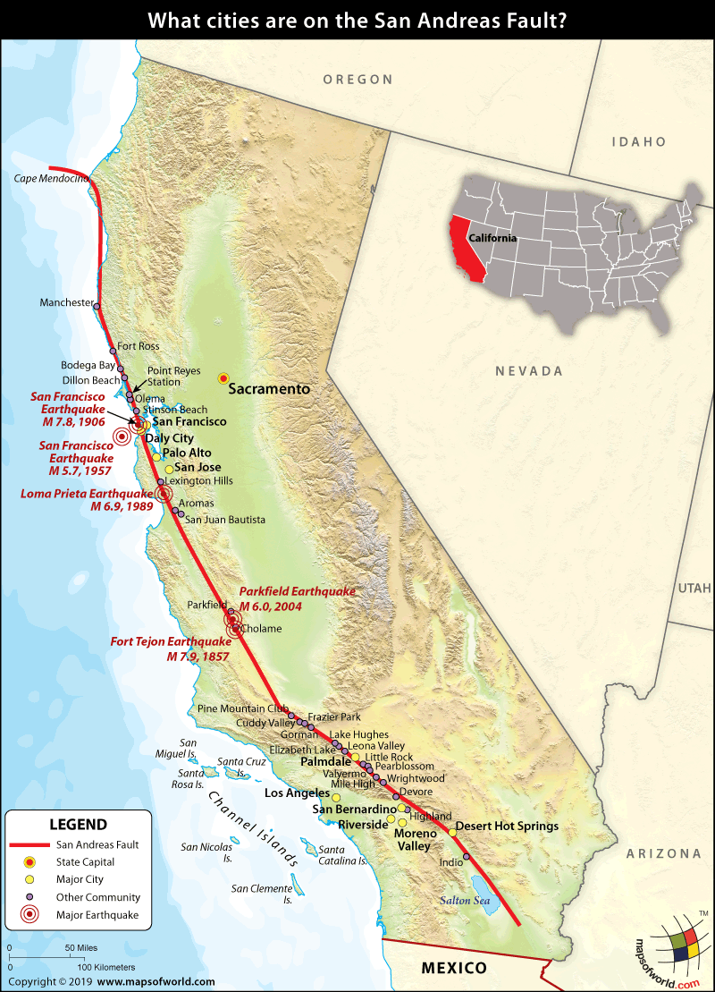
What Cities are on the San Andreas Fault?

In geology, a fault refers to a break or fracture in a plate or the rocks that make up the crust of the earth. One of the most essential characteristics to be observed is the movement of the rocks on either side of the fault lines. Such movements release built-up tension, often leading to earthquakes and some seismic activity. The San Andreas Fault Line is one of the biggest fault lines in the world, and it stretches over 750 miles (approximately 1,200 kilometers). It is the fault line that forms the boundary between the North American Tectonic Plate and the Pacific Plate. It starts at the Salton Sea and runs north to the Mendocino coast.
Some of the cities and communities that lie on the San Andreas Fault include:
- Bodega Bay
- Daly City
- Desert Hot Springs
- Frazier Park
- Gorman
- Moreno Valley
- Palmdale
- Point Reyes Station
- Riverside
- San Bernardino
- San Francisco
- San Jose (not on, but very near the fault line)
- Wrightwood
Apart from this, there are a number of other communities that are also on the San Andreas Fault line. These include:
- Amber Hills
- Aromas
- Bolinas
- Broadmore
- Cape Mendocino Area.
- Cholame
- Cuddy Valley
- Devore
- Dillon Beach
- Elizabeth Lake
- Emerald Lake Hills
- Fort Ross
- Highland
- Highlands-Baywood Park
- Hillsboro
- Indio
- Lake Hughes
- Leona Valley
- Lexington Hills
- Little Rock
- Los Trancos Woods
- Manchester State Beach
- Mile High
- Mussel Rock
- Olema
- Pacifica
- Parkfield
- Pearblossom
- Pine Mountain Club
- Portola Valley
- San Juan Batista,
- Stinson Beach
- Stonestown
- Valyermo
- Westridge
- Woodside
The San Andreas Fault runs through most of California – the most populated state in the US. Over 39.5 million people live in the state, and while San Andreas is not the only fault in the state, it is one of the major fault lines that leave Californians vulnerable to earthquakes.
Some of the notable earthquakes caused along the San Andreas Fault include:
- 1857 Fort Tejon Earthquake – Magnitude 7.9
- 1906 San Francisco Earthquake – Magnitude 7.8
- 1957 San Francisco Earthquake – Magnitude 5.7
- 1989 Loma Prieta Earthquake – Magnitude 6.9
- 2004 Parkfield Earthquake – Magnitude 6.0
Related Links:
Related Maps:


