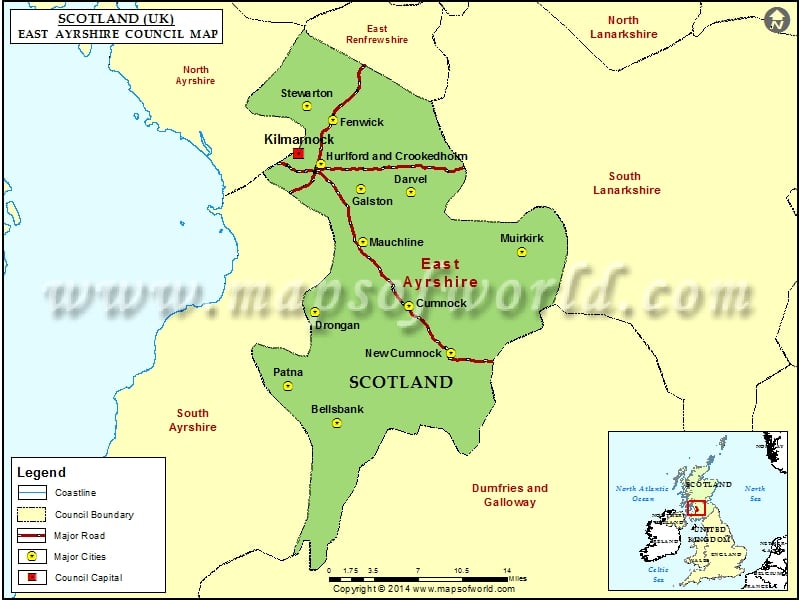
East Ayrshire forms a part of the thirty-two council territories of Scotland. It shares its borderline with Dumfries and Galloway, East Renfrewshire, South Lanarkshire, North Ayrshire, and South Ayrshire.
The home office of the council area is situated on London Road, Kilmarnock. With South Ayrshire and the territory regions of North Ayrshire, it framed the previous area of Ayrshire.
After the town of Cumnock, the biggest town is Kilmarnock, which is also the county’s capital. The region was structured in 1996, from the previous Loudoun and Kilmarnock and Cumnock and Doon Valley locale.
The region of Ayrshire can be portrayed by striking complexities, this area offers moving green slopes, a fluctuating coastline, beautiful sunny shores, and island enterprises. Ayrshire offers enticing malt whiskies in clamoring business sector towns and beautiful angling towns.
The region offers encapsulating attractions, which include castles, boat trips, and museums. Entertaining attractions are available for children as well as for adults. Some of the must-visit places of East Ayrshire, include Loudoun Castle, Dean castle, Kay park, Dick Institute, Burns Monument (Kilmarnock), etc.
Ayrshire is also an abode for various golf courses, such as Loudoun Gowf Golf Club and Rowallan Castle Golf & Country Club, where one can witness some of the best shots. This region in Scotland, is, therefore, a wonder in its own self.
Cities in East Ayrshire Council |
|||
| Council | City | Latitude | Longitude |
|---|---|---|---|
| East Ayrshire | Bellsbank | 55.311986 | -4.397585 |
| East Ayrshire | Patna | 55.35 | -4.5 |
| East Ayrshire | New Cumnock | 55.4 | -4.18 |
| East Ayrshire | Drongan | 55.435943 | -4.456429 |
| East Ayrshire | Cumnock | 55.45 | -4.27 |
| East Ayrshire | Mauchline | 55.52 | -4.37 |
| East Ayrshire | Muirkirk | 55.52 | -4.05 |
| East Ayrshire | Galston | 55.58 | -4.38 |
| East Ayrshire | Darvel | 55.58 | -4.28 |
| East Ayrshire | Hurlford and Crookedholm | 55.605564 | -4.46497 |
| East Ayrshire | Fenwick | 55.656832 | -4.445357 |
| East Ayrshire | Stewarton | 55.67 | -4.5 |

