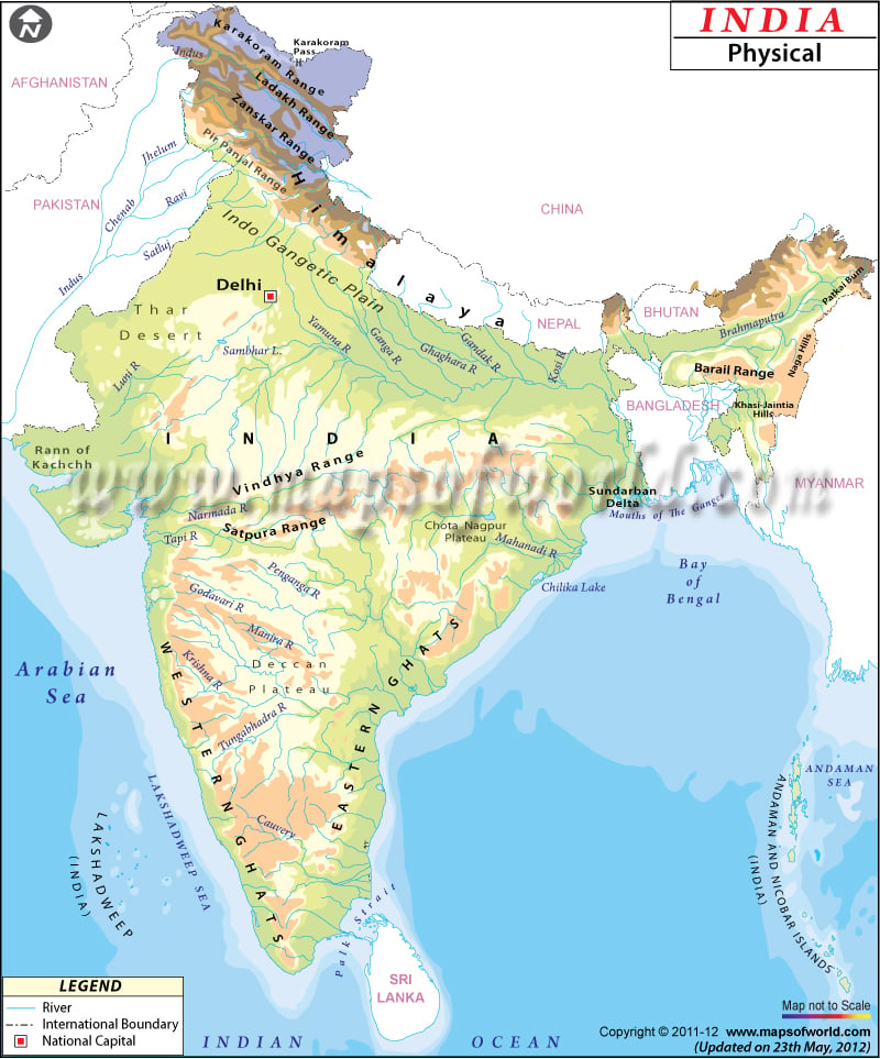
India, known as the Republic of India, officially is a country in South Asia. It shares its boundary with Pakistan to the west, China, Bhutan, and Nepal to the north, Myanmar and Bangladesh to the east, the Indian Ocean to the south, the Arabian Sea to the southwest, and the Bay of Bengal to the east.
Physical Features of India
The Andaman and Nicobar Islands of India. Share a maritime border with Indonesia, Thailand, and Myanmar. The map is beneficial for school presentations and other purposes. A map legend at the bottom helps all the signs, characters, graphics, and symbols used throughout the map. Delhi, the capital of India, is marked on the map. India is the seventh-largest country globally, covering a total area of 3,287,263 square kilometers (1,269,219 sq mi) and a coastline of 7,516.6 km (4,671). India is divided into the following physiographic regions:
Northern Mountains
The Himalayan mountain range defined the northern frontiers of India. These Mountain ranges were formed by tectonic plates collision of the Indian and Eurasian Plates and the world’s highest mountain range. Himalayas separate India from northeastern Asia extending from Jammu and Kashmir in the north to Arunachal Pradesh in the east. Kanchenjunga 8,586 m (28,169 ft) is the highest peak of India on the Sikkim-Nepal border in a section of the Himalayas.
The Peninsular Plateau
The main features of the Indian peninsular plateau consist of
-
Mountain ranges:
These ranges include the Aravali Range running across Rajasthan from northeast to southwest direction. Vindhya Range runs across most of Central India. Satpura range begins in eastern Gujarat and runs across Madhya Pradesh, Maharashtra, and Chhattisgarh.
-
Plateaus
: These plateaus include the Malwa plateau that spreads across Gujrat, Rajasthan, and Madhya Pradesh. Chota Nagpur Plateau covers most of Jharkhand and adjacent parts of Chattisgarh, Odisha, and Bihar. Deccan Plateau-a large triangular plateau, south Granulite terrain and Kutch Kathiawar Plateau.
-
Ghats
: This region includes western and Eastern Ghats. The Western Ghats, also called Sahyadri mountains, run along the western edge of the Deccan Plateau. The Eastern Ghats are discontinuous mountains that extend from west Bengal to Odisha.
Indo – Gangetic Plain
The region, also known as the great plains, is the large alluvial Plains that runs parallel to the Himalayas, from Jammu and Kashmir in the west to Assam in the east. The plain has a total area of 70,000 km2 (270,000 sq mi) and is often classified into four divisions: The Bhabar belt, The Tarai belt, The Bangar Belt, and lastly Khadar Belt. They are extensive alluvial plains formed by silt deposition by the many rivers.
Thar Desert
Thar desert forms a significant part of Western India. It is situated in the state of Rajasthan, covering about 61% of its geographic area. Luni River is the only river in this region.
Coastal plains
The region includes eastern coastal Plains and western coastal plains. The Eastern Coastal plain is the land area lying between the oceanic boundary of India and the Eastern Ghats. It stretches from West Bengal in the east to Tamil Nadu in the south. In contrast, the western coastal plain is the land area between the Arabian sea and the Western Ghats. It extends from Gujrat in the north to Kerala in the south.
Islands
The two major islands of India are Andaman, and the Nicobar Islands in the Bay of Bengal and Lakshadweep island in the Arabian Sea, and They are classified as union territories.
Rivers in India
The most significant rivers of India are Indus, Ganga, and Brahmaputra rivers, along with their tributaries, Satluj, Yamuna, Chambal, Kosi, Beas, and more. The four important rivers of southern India are Mahanadi, Godavari, Krishna, and Kaveri.

