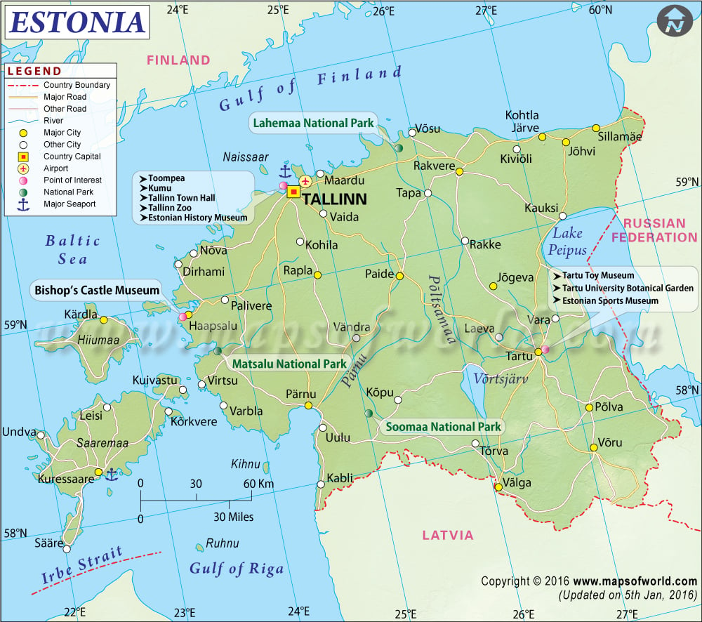
Explore this Estonia map to learn everything about this country. Learn about the location of Estonia on the world map, official symbol, flag, geography, climate, time zones, postal/area/zip codes, etc. Check out the history, significant cities, provinces/districts, the capital city’s location, most significant travel destinations and attractions, facts and trivia, Top FAQs (Frequently Asked Questions), and many more.
About Estonia
Estonia, known as the Republic of Estonia officially, is a small country in Northern Europe. The territory of the country consists of the mainland, the larger islands of Hiiumaa and Saaremaa over 2,200 other islands on the eastern coast of the Baltic Sea. Estonia covers a total land area of 45,339 square (17,505 sq mi). On 24 February 1918, the Independence of Estonia was declared, and the Estonian Provisional Government was formed. Estonian Restoration of Independence was proclaimed on 20 August 1991. The territory of Estonia is divided into 15 counties, including 13 on the mainland and three on the island. Check Key facts about Estonia to learn more about the country.
Flag of Estonia
The flag of Estonia was adopted in 1991. The flag’s design is a tricolor featuring three equal-sized horizontal bands of blue, black, and white (from top to bottom). Blue is for the valuated blue sky above the native land, Black depicts attachment to the soil of the homeland and the fate of Estonians, and white is for purity, hard work, and commitment.
Estonia Location
The Estonia Location Map shows the exact location of Estonia on the world map. This map outlines the boundaries of this country, neighboring countries, and oceans. Estonia’s continental mainland shares its border with the Gulf of Finland north, the Baltic Sea to the west, Latvia to the south, Lake Peipus, and Russia to the east.
Estonia’s Latitude and Longitude extents are 57.3 N and 59.5 N Latitude and 21.5. E and 28.1 E Longitude in Europe. One can check this Latitude and Longitude Map of Estonia for more information.
Estonia Capital
The capital city of Estonia is Tallinn. Tallinn is situated on a bay in northwest Estonia, on the shore of the Gulf of Finland of the Baltic Sea. Tallinn City is Estonia’s leading industrial, financial and cultural center and administratively lies in the Harju Maakond (County). Tallinn is located 187 km (116 mi) northwest of the country’s second-largest city Tartu. Check Tallinn Map to learn more.
Time Zones in Estonia
Estonia uses only a one-time zone, Eastern European Standard Time (EET). EET is two hours ahead of UTC (coordinated universal time), that is, UTC+2. Estonia observes daylight saving time as Eastern European Summertime (EEST), where the clocks are switched forward by 1 hour in summer (UTC + 3). Check Estonia Time Zone Map to learn more.
Estonia Geography
The physical map of Estonia has revealed all the details about the country’s physical features, including mountain peaks, rivers, and lakes. Geographically, the country is located on the eastern coast of the Baltic Sea on the northwestern part of the rising East European Platforms. The country is flat with a long and shallow coastline of (3,794 km or 2,357 mi) along the Baltic Sea, with around 1520 islands along the shore. The two biggest islands of the country are Saaremaa, at 2,673 km2 (1032 sq mi), and Hiiumaa, at 989 km2 (382 sq mi). Suur Munamagi (Egg Mountain) is the country’s highest point at 318 m (1043 ft).
Estonia Climate
The climatic conditions of Estonia are Temperate and Mild, generally characterized by warm summers and moderately severe winters. The country has four seasons of equal length. The coldest part of the country is Harju, and the warmest and rainiest part of the country is Tartu.
Estonia Major Cities
The Estonia Cities Map reveals valuable details, including the capital city and administrative divisions. Major cities of Estonia are:
- Tallinn (capital)
- Tartu
- Narva
- Parnu
- Kohtla-Järve
Estonia Airports
Estonia has 22 airports, with one large, five medium, and about 16 small airports. Here is Estonia Airport Map if you want to know more. The largest and busiest Airports in the country are:
- Lennart Meri Tallinn Airport
- Tartu Airport
- Kuressaare Airport
- Kardla Airport
- Parnu Airport
Estonia Postal or ZIP Codes
Postal codes in Estonia consist of five digits. The first two digits in the Estonia ZIP codes indicate the district (town or rural municipalities). The last three digits indicate the delivery office, delivery round, or significant customer (bureau de distribution, tournee du facteur ou grant client).
Estonia Travel
Travel and tourism options in Estonia have increased rapidly over the years. Estonia has a rich history and new culture, with innumerable lakes, forests, and beaches. There are many UNESCO World Heritage Sites as well. Some of the most popular tourist destinations of Estonia are:
- Tallinn
- Tartu
- Parnu
- Saaremaa
- Old Town in Tallinn
Top FAQs on Estonia
FAQ #1: Is Estonia a democracy?
Ans: Estonia is a parliamentary democracy.
Faq #2: Is Estonia part of Russia?
Ans: Estonia has been part of Russia since the end of the 18th century, but Estonia became independent after the Russian Revolution of 1917.
Faq #3 What language do they speak in Estonia?
Ans: The official language of Estonia is Estonian. Estonian is a Uralic language of the Finnic Branch.
Faq#4: Is Estonia in NATO?
Ans: Estonia has been a member of NATO since 29 March 2004.
Faq #5: When did Estonia gain Independence?
And: Estonia gained Independence on 24 February 1918.

