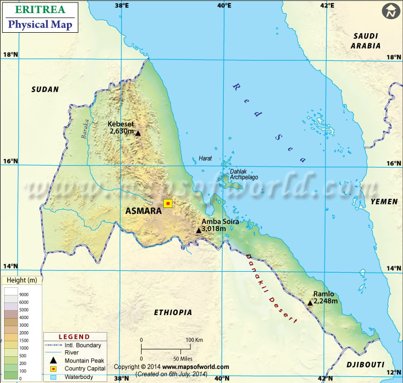
Eritrea is located on the Somali Peninsula of East Africa. It shares its boundary in the northwest and west with Sudan, in the south with Ethiopia, in the southeast with Djibouti, and in the east and northeast with the Red Sea. Eritrea is located at the southern end of the Red Sea and has 630 miles of coastline.
This map shows geography and trends in the height of Eritrea. Latitudes and Longitudes can also be noted. The latitudinal extent of the country is between 12. N and 18. N and the longitudinal extent of the country are between 36. E and 44. E. The capital of Eritrea, Asmara, is also marked on the map. East African Rift virtually bisects the country. Eritrea’s topographic features include:
Check: /lat_long/eritrea-lat-long.html
Central Highlands in Eritrea
Central Highlands is located in the country’s middle on a north-south axis. They are in a narrow strip and have about 6,500 feet (2,000 meters) above sea level. These highlands in Eritrea represent the northern reaches of the Ethiopian Plateau. The highest point is Mount Soria, at 9,885 feet (3,013 meters) as marked on the map. The highlands are narrower in the north of Eritrea, and then due to erosion activities, they end up in smaller hills. Asmara, the country’s capital, is located on a high plateau in the country’s center at 7,600 feet.
The Coastal plain in Eritrea
Coastal plains are located to the east of the highlands, stretching down to the country’s southeast. These plains are hot and arid. The plains are 10 to 50 miles (15 to 80 km) towards the north of the Gulf of Zula. Towards the south, they are comparatively wider and include Danakil plain. Danakil plains are the arid lowlands located in southeastern Eritrea. This region contains a depression known as Kobar Sink, more than 300 feet below sea level, and its northern end extends into Eritrea.
Western lowlands and Islands in Eritrea
Western lowlands are the broken and rolling plains of the west side of central highlands sloping towards the border with Sudan. It has an average height of about 1,500 feet (460 meters). The vegetation type is savanna consisting of shrubs and scattered trees.
In the Red Sea, off the coast, are the group of Dahlak Islands. It is a group of more than 200 small Coral and reef-fringed islands.
Principal Rivers of Eritrea
The major rivers drain Eritrean highlands: Tekeze, Gash, Baraka, and Anseba. The Tekeze River is a tributary of the Atbara River, which joins the Nile River eventually. Tekeze River forms part of the country’s border when it crosses the western lowland. Baraka and Anseba River flows northward into a marshy area on the east coast of Sudan. Other than that, several other seasonal streams flow eastward from the plateau and then reach the shore.
Physical Map of Neighbouring Countries

