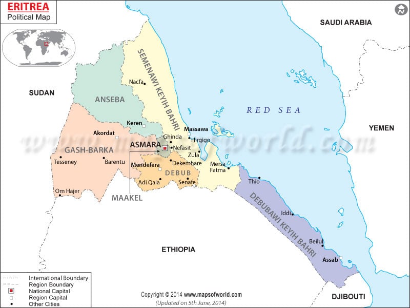
Eritrea’s political map provides detailed information on important cities, locations, states, and the state capitals of Eritrea. This country is located between Sudan and Djibouti. Asmera is the capital city of Eritrea. Some of the important cities include Nakfa, Barentu, Adi Keyih, Aseb, and Teseney.
Eritrea Location
Eritrea is a country that is located in eastern Africa between Sudan and Djibouti. It forms the border with the Red Sea. Located on the geographical coordinates of 15° North latitude and 39° East longitude, it covers an area of about 121,320 sq km. Eritrea’s political map helps to identify the important locations and cities of Eritrea.
Check: /lat_long/eritrea-lat-long.html
Border Countries
Eritrea is bordered by Sudan on the western side, Djibouti on the southern side, and Ethiopia on the southwestern side. These border countries are clickable on the Eritrea political map that leads the browser to the map of that particular country.
States of Eritrea
There are 9 states in the country of Eritrea. They are highlighted with dark black on the Printable Map of Eritrea. The different states of Eritrea are given below:
|
|
|
|
|
|
|
|
|
Cities of Eritrea
The cities of Eritrea can be identified on the Eritrea Map by the black dots put beside them. The cities of this country are Kerora, Nakfa, Keren, Akordat, Zula, Teseney, Barentu, Om Hajer, Adi Ugr, Dekemhare, Adi Keyih, Mersa Fatma, Beylul and Aseb.
Asmera, the capital city
The national capital of Eritrea is Asmera. A red square on the World Map Eritrea makes it easily identifiable. It is situated on the latitude of 15° 19′ 60″ North and longitude of 38° 55′ 60″ East. The city lies at an altitude of 2363 meters above sea level. Asmara International and Massawa International are the nearest airports to Asmera. Some of the nearby places include Godaif, Segdo, Adi Nifas, Ts’elot, Hinzi, and Ad Abeito.
| Region | Capital | Population | Area(km.²) | Old provinces |
|---|---|---|---|---|
| Anseba | Keren | 400,846 | 23,200 | Barka, Senhit |
| Debub | Mendefera | 702,502 | 8,000 | Akele Guzai, Seraye |
| Debubawi Keyih Bahri | Assab | 189,627 | 27,600 | Denkalia |
| Gash Barka | Barentu | 515,667 | 33,200 | Barka, Gash-Setit, Seraye |
| Maekel | Asmara | 502,300 | 1,300 | Asmara, Hamasien |
| Semenawi Keyih Bahri | Massawa | 392,653 | 27,800 | Akele Guzai, Denkalia, Sahel, Semhar |
| Province | Area(km.²) | Capital |
|---|---|---|
| Akele Guzai | 8,400 | Adi K’eyih (Adi Caieh, Adi Qayeh) |
| Asmara | 200 | Asmara (Asmera, Asmra) |
| Barka | 27,800 | Ak’ordat (Agordat) |
| Denkalia | 24,300 | Assab (Aseb, Asseb) |
| Gash-Setit | 18,600 | Barentu |
| Hamasien | 2,700 | Asmara (Asmera, Asmra) |
| Sahel | 16,400 | Nakfa |
| Semhar | 6,300 | Massawa (Massaua, Mesewa, Mits’iwa) |
| Senhit | 5,900 | Keren (Karen) |
| Seraye | 6,800 | Mendefera (Mendeferas) |
| 10 provinces | 117,400 |

