
 Wall Maps
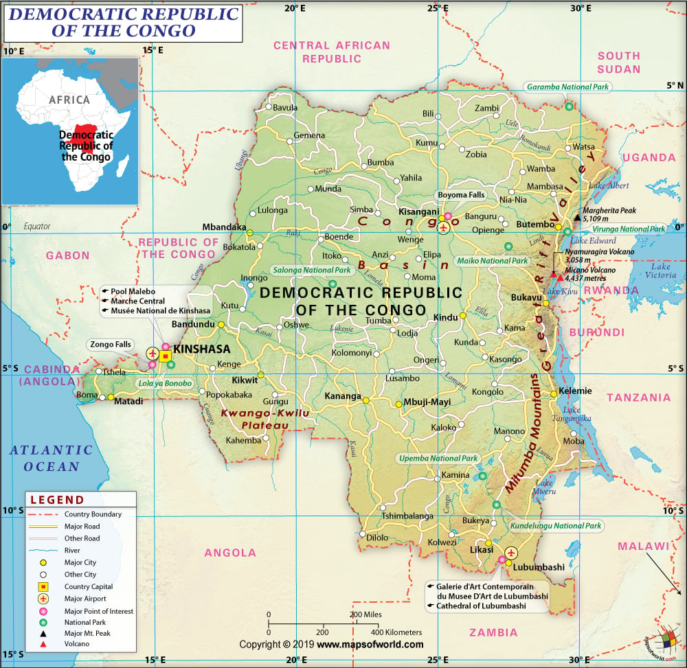
About Democratic Republic of Congo
Explore this Democratic Republic of Congo map to learn everything you want to know about this country. Learn about Democratic Republic of Congo location on the world map, official symbol, flag, geography, climate, postal/area/zip codes, time zones, etc. Check out Democratic Republic of Congo history, significant states, provinces/districts, & cities, most popular travel destinations and attractions, the capital city’s location, facts and trivia, and many more.
| Full name | Democratic Republic of the Congo |
| Capital City | Kinshasa |
| Language | French (official), Lingala, Swahili (other) |
| Currency | New Zaire (CFAF) |
| Religion | Roman Catholic, Protestant, Kimbanguist, Muslim, other beliefs |
| National Anthem | Debout Congolais |
| Newspaper | Digital Congo, Le Soft |
| Places to Visit | Goma, Kinshasa, Chutes de Lukia, Kinkole Fish Market, Kisanto Botanical Gardens |
| Transport | Avail the Kenya Airways and SN Brussels Airlines, that take off from the Kinshasa’s N’djili Airport which take you to Bujumbura, Douala, Abidjan, Johannesburg, Luanda, Lagos, Libreville and and Nairobi Kinshasa is well connected to the Democratic Republic of the Congo Take a ferry ride to the Brazzaville through the Congo River |
| Shopping | bracelets, baskets, African carvings, ebony carvings and paintings |
Democratic Republic of the Congo (DRC) was referred with different names that are still in use like the Congo Free State, Belgian Congo, Congo or Zaire. Congo-Kinshasa was yet another name given to the region just to differentiate it from the neighboring country of the Republic of Congo.
The province stands as third largest country in Africa while covering a land space of about 905,356 square miles.
The province stretches to reach huge expanses of dense forests, the mountain range of Ruwenzori, the Central Basin, the Highland Plateau, and the primitive mining towns.
Location Of Democratic Republic Of The Congo :
Democratic Republic of the Congo (DRC) is nestled in the province of Central Africa, sharing common borders with the Republic of Congo (northwest), Sudan (northeast), Central African Republic (north), Uganda, Burundi, Rwanda and Tanzania (east), Zambia (southeast), and Angola (southwest).
Physical Map Of Democratic Republic Of The Congo:
The Democratic Republic of the Congo constitutes over a large area by the Congo River Basin that covers a total land space of about 1 million square kilometer. The DRC is placed along the Equator, where one third of the province lies within the northern part while the rest two-thirds is located along the south. Along the northern bank of the Congo River, a contracted strip of land channels out to the Atlantic Ocean. Get to see a basin-shaped plateau along the low-lying central area that slant downwards towards the western front reaching the area of tropical rainforest. The province is engulfed by the mountainous terrains along the western front, by the plateaus that integrate with the savannas along the south and southwestern front, and impenetrable grasslands stretching along the Congo River near the northern front.
The eastern regions are marked with extremely high peaks that surely catch your glimpse. Kinshasa is the capital and largest city of the province with other cities like the Lubumbashi, Kolwezi, Kisangani, Mbuji-Mayi and Matadi, which are considered as the major seaport of the region.
Flag of Democratic Republic Of The Congo
The flag of Democratic Republic of the Congo is designed with a sky blue colored base, which is diagonally separated from one end to the other. The red colored band initializes from the lower hoist corner to the upper fly corner bordered by a narrow yellow colored stripe. A five-pointed star is placed along the left side corner along the hoist side. The color red symbolizes for the blood shed by the martyrs for their country’s freedom whereas the yellow color denotes the presence of richness and prosperity, while the color blue represents hope and the star placed within the flag symbolizes unity prevalent within the province.
Climate Of Democratic Republic Of The Congo :
Democratic Republic of the Congo witnesses a hot and humid climatic condition along the river basin especially prevalent in the lower western and central regions of the province. While the southern highlands were effected with cool and dry weather conditions. The months of October to May along the southern part of the equator is subjected to rainy season while the northern side of the equator experiences a heavy precipitation during the months of April to November. There is constant occurrence of rainfall within the Equator accompanied by thunderstorms during the wet season.
Flora and Fauna of Democratic Republic Of The Congo :
Get to see rare species of chimpanzees like the Common chimpanzee and the bonobo, which are even called as Pygmy Chimpanzee along the rainforests area of the province. Catch up with animals like mountain gorilla, okapi and white rhino that can be commonly sighted within the area. The national parks like the Garumba, Kahuzi-Biega, Salonga and Virunga National Parks, and the Okapi Wildlife Reserve, protect wildlife species within the region.
Among the floras take a glimpse at the beautiful trees that surround you especially species of red cedar, oak, walnut, mahogany, the silk-cotton tree, and varied species of palms. Among the native flowers, worth mentioning are the orchids, lilies, lobelias, and gladioli along with the species of the euphorbia and landolphia floral genres.
People Of Democratic Republic Of The Congo
There are about 250 ethnic groups residing within the region of Democratic Republic of the Congo, among which reference can be made of Kongo, Luba, and Mongo.
About seven hundred local vernaculars exist within the region out of which the resident national languages being dialects like the Lingala, Tshiluba and Swahili. French is the official dialect of the area, is commonly used here.
Literally about 80 percent of the Congolese population is Christians, prevalent mainly with the existence of the Roman Catholic. The Protestant church stands largest within the region with prominent names being the Anglican Church of Congo, Église des Frères Mennonites and the Église du Christ au Congo. Local ancestors residing within the region once practiced and believed in monotheism, animism, ancestor worship, witchcraft, and black art magic.
Arts, Culture and Music Of Democratic Republic Of The Congo
Art: With the boom in the copper industry within the southern region of Katanga, a traditional art form was still maintained within the region wherein portraits were drafted within a copper sheet, thereby enclosed with clays and textures. Several recognized African state heads have imprinted their portrait on this metal. One can look out for handcraft-based arts, mats made of raffia palm trees, woodcarvings, paintings, baskets, jewelry, and masks. Paintings created during the post independence war period expresses themes based on exploitation, poverty, and inequality.
Culture: The culture of Democratic Republic of the Congo is mainly affected by the Western influences. People are generous in nature and confer local guests with wonderful gifts. A chicken or a goat is usually butchered for any kind of festival celebration that is indulged in by the native people. Singing and dancing is the sole form of entertainment accompanied with brewing of customary beer and palm. The local natives uses Ingot Crosses, a belief on which they keep their complete faith on, brings along wealth and possession within the area.
Music: Kwasa-kwasa is the local music, which can be heard very often by the local natives. Music dances are quite popular in the area, which is accompanied with musical instruments like the thumb piano and drums. Congo jazz and soukous is some of the pouplar tunes that are played along with a guitar. Mbuti natives have set along their own style of vocal tunes, which is widely accepted within the area.
Economy Of Democratic Republic Of The Congo
The Democratic Republic of the Congo is filled with abundant natural possessions and mineral riches, as the economy witnessed decline during the month of 1980s. The economy depends largely on the agricultural industry, while contributing to about 57% of the GDP within the area. Among the agricultural produce coffee, palm oil, rubber, cotton, sugar, tea, and cocoa are accordingly cultivated. It is the agricultural industry that engages about 66 % of the present population with provisions for crops like cassava, plantains, maize, groundnuts, and rice. The country gains its revenue income from the mining sector and even stands in the fourth position while being the largest producer of the industrial diamonds. The copper and cobalt production governed by the Gecamines is the only state-owned mining industry within the area.