About Central African Republic
Explore this Central African Republic map to learn everything you want to know about this country. Learn about Central African Republic location on the world map, official symbol, flag, geography, climate, postal/area/zip codes, time zones, etc. Check out Central African Republic history, significant states, provinces/districts, & cities, most popular travel destinations and attractions, the capital city’s location, facts and trivia, and many more.
| Official Name | Republique Centrafricaine |
| Capital | Bangui |
| Population (2001) | 3.8 million |
| Area | 622,984 sq km or 240,535 sq mi |
| Currency | CFA Franc ($1=724.11) |
| Religion | Christianity, Islam & tribal beliefs |
| Literacy | 60% |
| Languages | French & Sangho |
| Major Cities | Bangui, Bambari, Bourar |
| Climate | Hot and humid |
The capital city of Central African Republic is Bangui. Some of the other cities in the country are Bimbo, Berberati, Carnot, Bambari and Bouar.
A landlocked country, Central African Republic lies in the heart of equatorial Africa. The country gained independence in 1960 and today is known for its diamonds, which account for more than half of the export earnings.
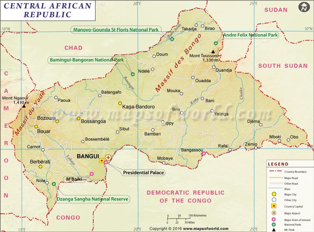
Physical Map of Central African Republic
Most of the land is a plateau that ranges in elevation from about 2,000 to 2,600 ft.
Two ranges of hills in the north and northeast rise to maximum heights of about 4,600 ft.
The country is has several major rivers – the Bamingui and Ouham rivers in the north, and the Ubangi, a tributary of the Congo, in the south.
Location of Central African Republic
Central African Republic is bordered on the north by Chad, on the east by Sudan, on the south by the Democratic Republic of the Congo (DRC, formerly Zaire) and the Republic of the Congo, and on the west by Cameroon.
Climate of Central African Republic
The climate of the Central African Republic is hot and humid with the average annual temperature remaining at about 26°C. Rainy season lasts from June to November, which sees tornadoes and floods. Annual rainfall varies from about 1,800 mm in the Ubangi River valley to about 200 mm in the semiarid north.
Flag of Central African Republic
The flag of Central African Republic is made up of four equal horizontal bands of blue at the top, white, green, and yellow with a vertical red band in center. A yellow five-pointed star is present on the hoist side of the blue band.
Flora And Fauna of Central African Republic
Most of the country has savanna vegetation, which is a grassland distributed with trees. Open grassland is found in the extreme north, and a dense rain forest covers the major part of the southwestern area. Commercially valuable trees include the sapele mahogany and the obeche. As far as fauna is concerned, almost every animal of the African Tropics is found in the country.
People of Central African Republic
The country is made up of ethnic groups like the Baya, Banda, Sara, Mandjia, Mboum, and M’Baka. About 49 percent of the population live in small villages, and follow traditional customs. An estimated 15 percent of the total population follows traditional religions, about 45 percent are Christians and 16 percent are Muslims. French is the official language, but Sango, an African language, is the also widely spoken. Apart from this, other African languages are also spoken.
Economy of Central African Republic
Agriculture forms the main base for economy, while mineral resources are relatively undeveloped. Some 80 percent of the population earns its livelihood by farming, fishing, or working in forestry. Diamonds is one of the most exploited minerals. Deposits of uranium exist, as well as iron ore, gold, lime, zinc, copper, and tin. The principal sources of revenue are diamonds, coffee, tobacco, cotton, and timber exports but export is often hindered by the difficulty of transporting goods to a seaport. The agricultural output is fairly evenly balanced between subsistence and export crops. The national budget in 1991 showed revenues at $175 million and expenditures at $312 million.

 Wall Maps