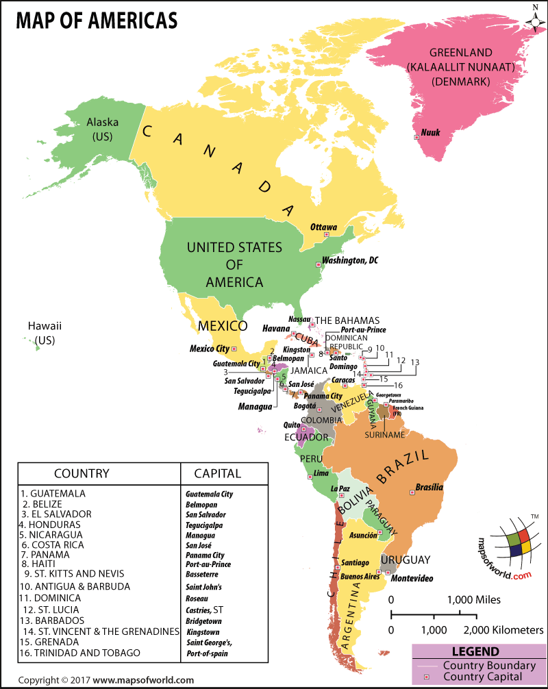
Explore this Map of North and South America, consisting of North America and South America. Including all associated islands, the Americas represent 28.4% of the Earth’s land area. You can also check this World Map America Centered which shows the America in the center of a world map.
Map of Americas
We have created the ultimate Map of Americas, showing both North America and South America, along with the islands that are associated with continents.
The map encompasses both American continents, as they make up most of the western hemisphere. North America with its 16.5% of the earth’s total land, is divided into 23 countries, and South America represents 12% of the earth’s land, with 12 countries.
This map shows the longest north-to-south landmass in the world, as well as all the countries, and their respective capitals.
History of the Americas
The Americas have been inhibited for almost 20,000 years. It is believed that the earlier inhabitants had come from the Asian continent as a result of and ‘ice bridge,’ during the Ice Age. Large-scale European colonization of the Americas started with the voyage of Christopher Columbus in 1492. Thereafter many European traveled to the continent.
This led to a mixing of cultures, destruction of cultures, and rising of new ones, along with new civilizations and states. The Spanish took over what is now known as the southwestern US, Florida, and the Caribbean. England took control of the east coast, and the North Pacific coast of Canada. France established its colonies in Quebec, and most of eastern Canada, with the Dutch settling in New.
This is how their respective languages spread across the continents with 376 million Spanish speakers today, 348 million English speakers, and 201 million Portuguese speakers and host of other languages. Despite the nearly equal diversity in languages, Christianity is the most popular religion in both continents.
Geography of Americas
The southernmost point in the Americas is the Islands of, Southern Thule, sometimes considered as part of Antarctica, and the northernmost point is the island of Kaffeklubben. Not only the north tip of North America, but also considered to be the northernmost point of land in the world. There are long mountain ranges running north-south on both continents.
The Andes spread along the west coast of South America, and the Rocky Mountains traverse west-central North America. The Appalachian dominate the east coast of North America, and the eastern coast of Canada under a different name.
The climate varies depending on the region: From Tropical rainforest in the amazon, to snow caped mountain on both continents.
North America, like many areas, is prone to extreme weather. Tornadoes and hurricanes are common in the south and southeast of the North America. They are formed by the collision of weather systems, specifically dry and cool air from Canada colliding with wet and warm air from the Atlantic. Once they start, the results can be deadly.
The total populations of the continents is 951 million people, 565 million reside in North America, and 386 million in South America. Here is a full list of the countries that this map covers along with their capitals :
North America Countries |
|---|
| Country | Capital city |
|---|---|
| Antigua and Barbuda | Saint John’s |
| Bahamas | Nassau |
| Barbados | Bridgetown |
| Belize | Belmopan |
| Canada | Ottawa |
| Costa Rica | San Jose |
| Cuba | Havana |
| Dominica | Roseau |
| Dominican Republic | Santo Domingo |
| El Salvador | San Salvador |
| Greenland | Nuuk |
| Grenada | Saint George’s |
| Guatemala | Guatemala City |
| Haiti | Port-au-Prince |
| Honduras | Tegucigalpa |
| Jamaica | Kingston |
| Mexico | Mexico City |
| Nicaragua | Managua |
| Panama | Panama City |
| Saint Kitts and Nevis | Basseterre |
| Saint Lucia | Castries |
| Saint Vincent and the Grenadines | Kingstown |
| Trinidad and Tobago | Port of Spain |
| United States of America | Washington, D.C. |
South America Countries |
|---|
| Country | Capital city |
|---|---|
| Argentina | Buenos Aires |
| Bolivia | La Paz (administrative), Sucre (judicial) |
| Brazil | Brasilia |
| Chile | Santiago |
| Colombia | Bogotá |
| Ecuador | Quito |
| Guyana | Georgetown |
| Paraguay | Asunción |
| Peru | Lima |
| Suriname | Paramaribo |
| Uruguay | Montevideo |
| Venezuela | Caracas |
Major Cities and Travel Destinations in the Americas
Some of the biggest cities in the Americas are Mexico City, New York City, Los Angeles, Chicago, Toronto, São Paulo, Buenos Aires, Rio de Janeiro, Lima, and Bogotá.
There are a great many more travel destinations than these major cities…Some notable places are; the Galapagos Islands, Cusco, Costa Rica, Argentine Patagonia, Panama City, Belize, Santiago, (both of them) in the South and Central America, Sima de las Cotorras, Horseshoe Bend, Athabasca Glacier, Crowsnest Pass, Antelope Canyon, Tamul Water Falls, and so much more throughout the Americas.
Economy of the Americas
Together, the two continents have a total GDP of US$20.971 trillion, and a 3% growth per capita, which makes about US $21,989 trillion.
Americas Facts
- The largest country in South America is Brazil, compared to the smallest county, Suriname, that is 50 times smaller than Brazil.
- 150 different languages are spoken in Brazil alone.
- Both Americas got their names from the Italian explorer named Amerigo Vespucci.
- Most common languages in North America are English, Spanish, and French.
- The first Native Americans are believed to have migrated to North America from the Asia continent.

