Location Map Of M 6.5 Earthquake In Aceh, Indonesia |
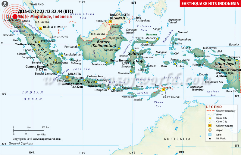 |
Many buildings have been flattened and at least 97 people were killed and dozens were missing after a magnitude 6.5 hit at about 5am local time the northern Indonesian provience of Aceh. |
M6.2 Earthquake in Indonesia |
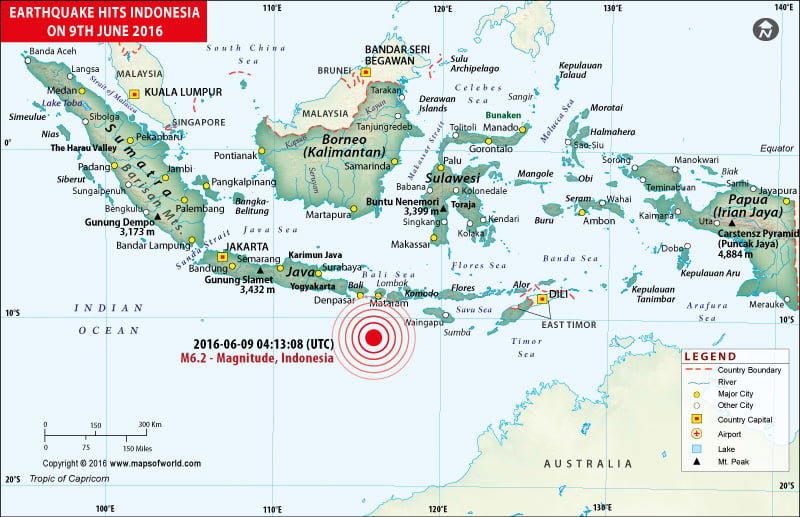 |
Map showing the epicenter of M6.2 Earthquake in Indonesia |
M6.3 Earthquake in Indonesia |
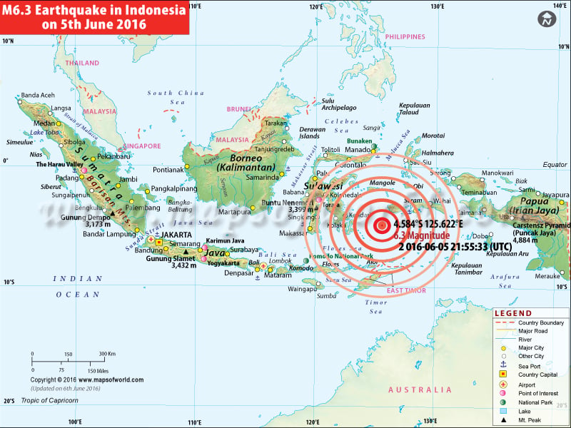 |
A 6.3-magnitude earthquake occurred in the Banda Sea in the remote eastern Indonesia. However, no tsunami warning has been issued. |
M6.5 Earthquake in Indonesia |
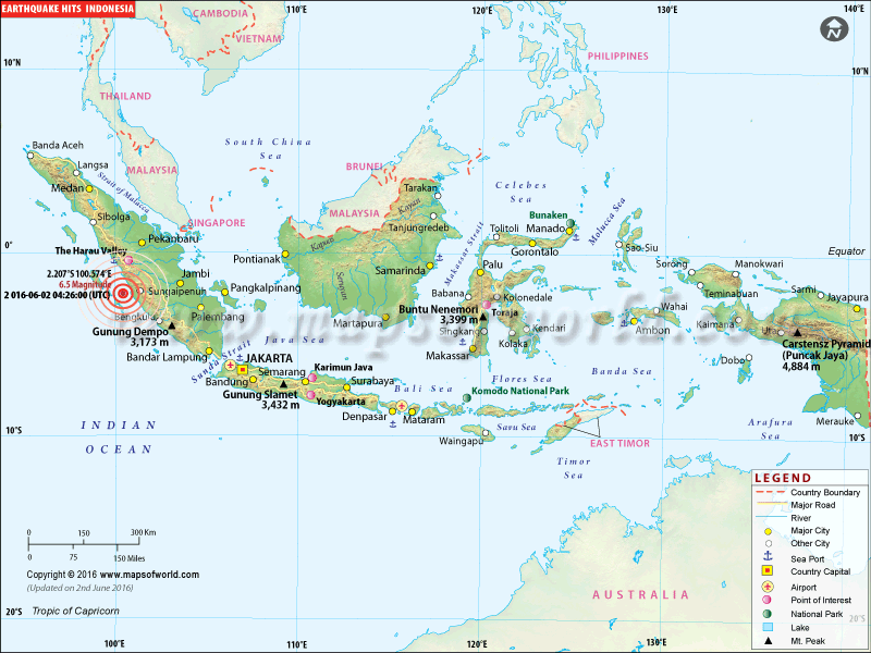 |
Map showing the epicenter of M6.5 Earthquake in Indonesia |
M7.9 Earthquake in Indonesia |
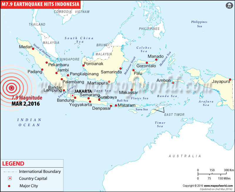 |
Map showing the epicenter of M7.9 Earthquake hits Indonesia on Mar 02, 2016. |
M6.5 Earthquake in Andekantor, Indonesia |
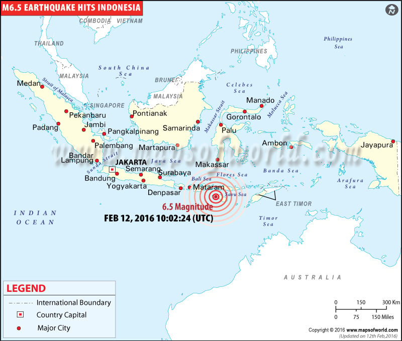 |
Map showing the epicenter of M6.5 Earthquake hits in Andekantor, Indonesia on Feb 12, 2016. |
Location map of M6.9 Earthquake in Indonesia - Dec 09, 2015 |
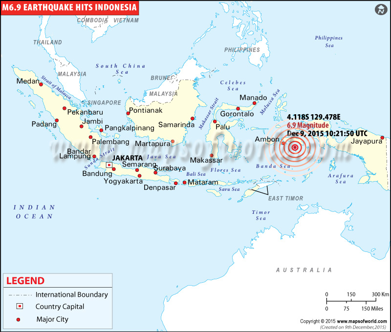 |
Map showing the epicenter of M6.9 Earthquake hits in Banda Sea, Indonesia on Dec 09, 2015. |
Location map of M6.4 earthquake in Indonesia |
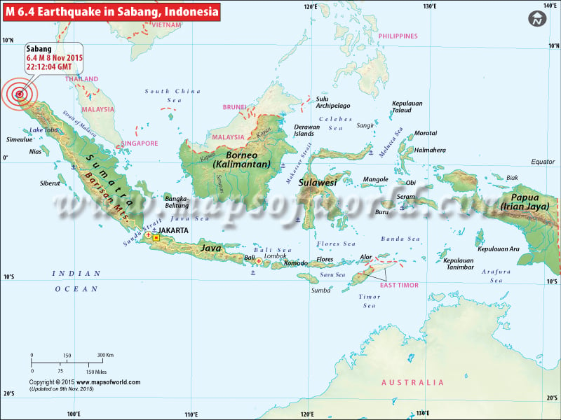 |
Map showing the epicenter of M6.4 Earthquake, Hits Indonesia on Nov 08, 2015. |
Location map of M6.3 earthquake in Indonesia |
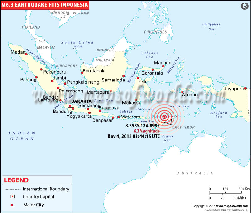 |
Map showing the epicenter of M6.3 Earthquake, Hits Indonesia on Nov 04, 2015. |
M6.6 Earthquake Hits Indonesia - Sep 24, 2015 |
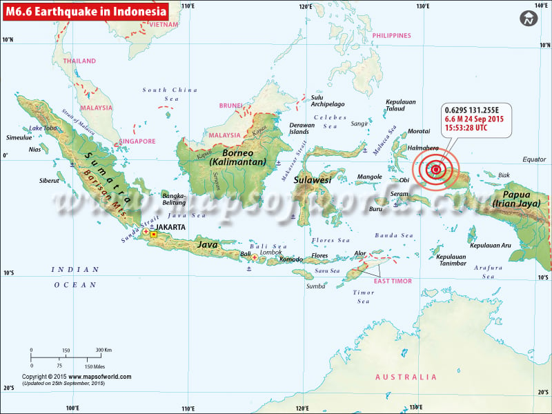 |
Map showing the epicenter of M6.6 Earthquake Hits Indonesia on Sep 24, 2015. |
M6.3 Earthquake Hits Indonesia - Sep 16, 2015 |
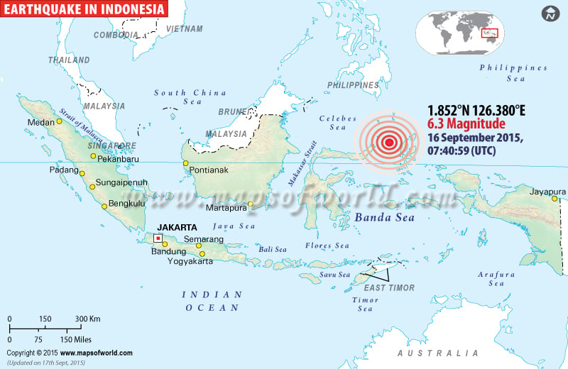 |
Map showing the epicenter of M6.3 Earthquake Hits Indonesia on Sep 16, 2015. |
M7.0 Earthquake Hits Papua, Indonesia - Jul 27, 2015 |
 |
Map showing the epicenter of M7.0 earthquake in Indonesia on Jul 27, 2015. |
Areas Affected by Earthquakes in Indonesia |
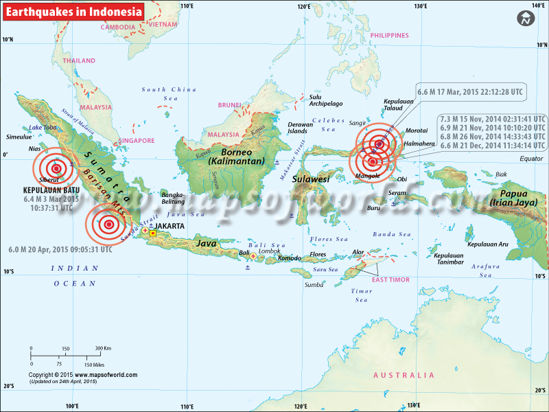 |
Map showing the epicenter of all major earthquakes occured in Indonesia. |
Indonesia Earthquake Map
7.5 magnitude earthquake strikes Indonesia
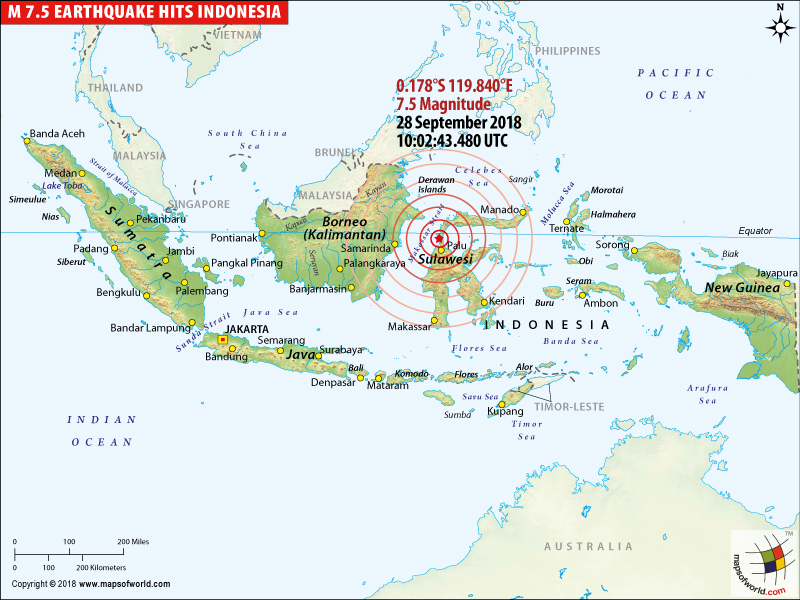
| Description :Indonesia map showing the epicenter of M7.5 earthquake hits Minahasa, Sulawesi, Indonesia on September 28, 2018. |
| Disclaimer |
Turning ground into liquid, death toll on a surge in Palu
3 October, 2018
In the aftermath of the earthquake and the ensued tsunami in Indonesia, the death toll is reordered to be 1,350. The event has resulted in a mass burial everyday. There are still numerous bodies lying in the rubble of ruined buildings or the Tsunami waves, that reached to a 20-feet high at certain places. Affecting the lives of almost 1 million people inhabiting the areas, the dual disasters have forced the country's officials to seek the cause of failure in early warning detection.
The collective system of seismographic sensors, buoys, tidal gauges and GPS, that were completed in 2008, bore the blame for the failure in deliverance of early warnings and the high death toll. The country with 22 open water tsunami buoys, lacked maintenance and were vandalised, which furthered their dysfunction, at the time of the occurrence of the event.
The after effects also includes the liquefaction, causing the soil to lose its ability to support structures and destroying vast spreads of neighbourhoods entirely. The bridges have been down and roads destructed, leaving rescue efforts in vain. The main challenge before the nation is to get supplies to the areas that have been cut off, following the breakdown of roadways.
People have been stranded without access to drinking water, food supplies and electricity and have resorted to raiding shops for basic necessities. Police officers are forced to take up distribution measures for endurance. With highly unstable and constantly moving earth, the search operations have been futile and have anticipated for hike in the number of deaths.
A 7.5 magnitude tremor triggered a tsunami hitting beach cities of Indonesia
29 September, 2018
Following the earthquake on Friday of magnitude 7.5, a tsunami struck the Indonesian Island of Sulawesi. Thousands of people were forced to sleep outdoors in order to evade repercussions. Buildings have either collapsed or been swept away by water in Palu city. A death toll of 348 people has been reported by the Indonesia's Disaster Management Agency. A snap in the electricity and communication lines has aggravated the damage. The quake triggered a tsunami with waves as high as 1.5 metres (five feet), leaving a figure of 350 people wounded and bedridden in hospitals, in Palu. The main airport in Palu, capital of South Sulawesi province, was closed down and is expected to remain shut for at least next 24 hours. The Indonesian President Joki Widodo, promised situation-monitoring and post-earthquake relief. Indonesian National Armed Forces troops, have also been deployed for rescue and aid purposes.
7.5 magnitude earthquake strikes Indonesia; brings down houses.
28 Sep 2018 10:02:43 UTC
On Friday, Indonesia was hit by multiple earthquakes near the central Sulawesi region. Numerous buildings have been damaged and over 10 people are gravely injured. The string of deadly earthquakes, including one with 7.5 magnitude, had raised Tsunami alerts, but they were called off within one hour. People in Indonesia have been advised to remain on alert, and away from the damaged buildings, as aftershocks are plausible.
The country is located near the 'Ring of Fire' – the major area in the basin of Pacific Ocean where numerous earthquakes and volcanic eruptions take place. In year 2004, magnitude-9.1 earthquake had struck the western part of Indonesia, which led to tsunami that took lives of over 230,000 people in different countries.
6.5 magnitude earthquake strikes Indonesia; three dead
Dec 16, 2017 2017-12-15 16:47:56 UTC: A 6.5 magnitude earthquake struck Indonesia’s main island of Java on Friday. At least three people were killed in the earthquake. According to the US Geological Survey, the earthquake struck just outside Cipatujah, a coastal town on Java Island. The earthquake had a depth of 91 km. The tremors of the earthquake were felt as far as the Indonesian capital of Jakarta, which is around 190 miles from the epicenter.
Earthquake Hits Northern Territory and Indonesia
Also Explore: Indonesia Map, Cities in Indonesia, Where is Indonesia?
97 people were killed in M 6.5 Earthquake in Aceh province, Indonesia - Dec 6, 2016
Dec 6, 2016: Many buildings have been flattened and at least 97 people were killed and dozens were missing after a magnitude 6.5 hit at about 5am local time the northern Indonesian provience of Aceh. The epicenter was 12 miles (19 kilometers) southeast of the town of Sigli in Aceh province. There is no tsunami alert.
6.2 magnitude earthquake hits Indonesia
2016-06-09 04:13:08 (UTC): A massive earthquake struck the coasts of Indonesia. According to the United States Geological Survey, the 6.2-magnitude earthquake struck off the Indonesian island of Lombok. Another earthquake, which measured 6.6 on the Richter scale hit Sungaipenuh, a city in Indonesia. There is no tsunami alert.
6.3-magnitude earthquake hits Indonesia
2016-06-05 16:25:33 (UTC) : A 6.3-magnitude earthquake occurred in the Banda Sea in the remote eastern Indonesia. However, no tsunami warning has been issued. According to the US Geological Survey, the earthquake struck at a depth of 428 kilometers and some 300 kilometers from Ambon Island. There have been no reports of casualties or damages.
6.5 magnitude earthquake strikes the Indonesian island of Sumatr
2016-06-01 22:56:00 (UTC) : A 6.5 magnitude earthquake struck the Indonesian island of Sumatra. According to the US Geological Survey, the epicenter of the powerful earthquake was located approximately 25 miles from the coast. Tremors of the earthquake were felt as far away as Singapore. No reports of casualties or damages are available.
7.9 magnitude earthquake strikes Indonesia
Mar 2, 2016 - The US Geological Survey has reported that a 7.9 magnitude earthquake struck off the coast of Western Indonesia at 19:49 local time (12:49 GMT). So far, there have been no reports of damage to life or property; however, authorities have issued tsunami warning for West Sumatra, Aceh and North Sumatra. The epicenter of the earthquake was 808km southwest of Padang city and it was 10 km deep.
Earthquake Affected Areas
| S. No. | Location | Distance in KM | Distance in Miles |
|---|---|---|---|
| 1 | SW of Muara Siberut, Indonesia | 659km | 409mi |
| 2 | SW of Pariaman, Indonesia | 804km | 500mi |
| 3 | WSW of Padang, Indonesia | 805km | 500mi |
| 4 | WSW of Solok, Indonesia | 843km | 524mi |
| 5 | NNW of West Island, Cocos Islands | 849km | 528mi |
Indonesia hit by a powerful 6.5 magnitude earthquake
Feb 12, 2016 - Indonesia was struck by a powerful 6.5-magnitude earthquake. US seismologists say that no tsunami warning has been immediately issued. According to media reports, the earthquake has a depth of 30km and was centered two miles east-southeast of Andekanter in Indonesia’s Sumba region. There were no immediate reports of damage or casualties.
An earthquake has occurred with magnitude: 6.9 SR, 99 km South East Malukutengah, at: 09-Dec-15 10:21:49 UTC, No Tsunami threat.
Earthquake Affected Areas
| S. No | Location | Distance |
|---|---|---|
| 1 | Dili, East Timor | 77km (48mi) WNW |
| 2 | Atambua, Indonesia | 83km (52mi) N |
| 3 | Kefamenanu, Indonesia | 129km (80mi) NNE |
| 4 | Soe, Indonesia | 179km (111mi) NNE |
| 5 | Dili, East Timor | 77km (48mi) WNW |
Strong quake hits Papua, Indonesia; no tsunami alert
Jakarta, Sep 24 (IANS)A strong quake measuring 6.8 on the Richter scale jolted West Papua and eastern most parts of Indonesia on Thursday, but it did not have the potential to create a tsunami, the Meteorology and Geophysics Agency said here.
| Preliminary Earthquake Report | |
|---|---|
| Magnitude | 6.6 |
| Date-Time | 24 Sep 2015 15:53:28 UTC, 25 Sep 2015 00:53:29 near epicenter, 24 Sep 2015 19:53:28 standard time in your timezone |
| Location | 0.629S 131.255E |
| Depth | 24 km |
| Distances | 28 km (17 mi) N of Sorong, Indonesia, 315 km (195 mi) W of Manokwari, Indonesia, 396 km (245 mi) NE of Amahai, Indonesia, 445 km (275 mi) SE of Tobelo, Indonesia, 951 km (589 mi) SSW of Koror Town, Palau |
| Location Uncertainty | Horizontal: 6.8 km |
| Parameters | Nph = 173, Dmin = 276.4 km, Rmss = 1.19 seconds, Gp = 19° |
| Earthquakes in Indonesia | |||
| Date | Location | Magnitude | Fatalities |
|---|---|---|---|
| Jan 20, 1917 | Bali, Indonesia | Fatalities 1,500 | |
| Feb 1, 1938 | Banda Sea, Indonesia | M 8.5 | |
| Jan 24, 1965 | Sanana, Indonesia (Ceram Sea) | M 7.6 | Fatalities 71 |
| Jun 25, 1976 | Papua, Indonesia | M 7.1 | Fatalities 5,000 |
| Dec 12, 1992 | Flores Region, Indonesia | M 7.8 | Fatalities 2,500 |
| Jun 4, 2000 | Southern Sumatera, Indonesia | M 7.9 | Fatalities 103 |
| Oct 10, 2002 | Irian Jaya, Indonesia | M 7.6 | Fatalities 8 |
| Nov 2, 2002 | Northern Sumatera, Indonesia | M 7.4 | Fatalities 3 |
| May 26, 2003 | Halmahera, Indonesia | M 7.0 | Fatalities 1 |
| Jan 28, 2004 | Seram, Indonesia | M 6.7 | |
| Feb 5, 2004 | Irian Jaya, Indonesia | M 7.0 | Fatalities 37 |
| Feb 7, 2004 | Irian Jaya, Indonesia | M 7.3 | |
| Jul 25, 2004 | Southern Sumatra, Indonesia | M 7.3 | |
| Nov 11, 2004 | Kepulauan Alor, Indonesia | M 7.5 | Fatalities 34 |
| Nov 26, 2004 | Papua, Indonesia | M 7.1 | Fatalities 32 |
| Dec 26, 2004 | Sumatra - Andaman Islands | M 9.1 | Fatalities 227,898 |
| Jan 1, 2005 | Off the West Coast of Northern Sumatra | M 6.7 | |
| Feb 19, 2005 | Sulawesi, Indonesia | M 6.5 | |
| Feb 26, 2005 | Simeulue, Indonesia | M 6.8 | |
| Mar 2, 2005 | Banda Sea | M 7.1 | |
| Mar 28, 2005 | Northern Sumatra, Indonesia | M 8.6 | Fatalities 1,313 |
| Apr 10, 2005 | Kepulauan Mentawai Region, Indonesia | M 6.7 | |
| May 14, 2005 | Nias Region, Indonesia | M 6.7 | |
| May 19, 2005 | Nias Region, Indonesia | M 6.9 | |
| Jul 5, 2005 | Nias Region, Indonesia | M 6.7 | |
| Nov 19, 2005 | Simeulue, Indonesia | M 6.5 | |
| Jan 27, 2006 | Banda Sea | M 7.6 | |
| Mar 14, 2006 | Seram, Indonesia | M 6.7 | Fatalities 4 |
| May 16, 2006 | Nias Region, Indonesia | M 6.8 | |
| May 26, 2006 | Java, Indonesia | M 6.3 | Fatalities 5,749 |
| Jul 17, 2006 | South of Java, Indonesia | M 7.7 | Fatalities 730 |
| Jan 21, 2007 | Molucca Sea | M 7.5 | Fatalities 4 |
| Mar 6, 2007 | Southern Sumatra, Indonesia | M 6.4 | Fatalities 67 |
| Jul 26, 2007 | Molucca Sea | M 6.9 | |
| Aug 8, 2007 | Java, Indonesia | M 7.5 | |
| Sep 12, 2007 | Southern Sumatra, Indonesia | M 8.5 | Fatalities 25 |
| Sep 12, 2007 | Kepulauan Mentawai region, Indonesia | M 7.9 | |
| Sep 20, 2007 | Southern Sumatra, Indonesia | M 6.7 | |
| Oct 24, 2007 | Southern Sumatra, Indonesia | M 6.8 | |
| Nov 25, 2007 | Sumbawa Region, Indonesia | M 6.5 | Fatalities 3 |
| Feb 20, 2008 | Simeulue, Indonesia | M 7.4 | Fatalities 3 |
| Feb 25, 2008 | Kepulauan Mentawai region, Indonesia | M 7.2 | |
| Nov 16, 2008 | Minahasa, Sulawesi, Indonesia | M 7.4 | Fatalities 6 |
| Jan 3, 2009 | Near the North Coast of Papua, Indonesia | M 7.7 | Fatalities 5 |
| Jan 3, 2009 | Near the North Coast of Papua, Indonesia | M 7.4 | |
| Feb 11, 2009 | Kepulauan Talaud, Indonesia | M 7.2 | |
| Aug 16, 2009 | Kepulauan Mentawai region, Indonesia | M 6.7 | |
| Aug 28, 2009 | Banda Sea | M 6.9 | |
| Sep 2, 2009 | Java, Indonesia | M 7.0 | Fatalities 81 |
| Sep 30, 2009 | Southern Sumatra, Indonesia | M 7.5 | Fatalities 1,117 |
| Oct 1, 2009 | Southern Sumatra, Indonesia | M 6.6 | |
| Oct 24, 2009 | Banda Sea | M 6.9 | |
| Nov 8, 2009 | Sumbawa region, Indonesia | M 6.6 | Fatalities 2 |
| May 9, 2010 | Northern Sumatra, Indonesia | M 7.2 | |
