- Texas Counties - Texas County Map, Map of Texas Counties
- Major Cities of Texas - San Antonio, Galveston, Houston, Dallas, Fort Worth, Abilene, Austin, Arlington, El Paso, Grand Prairie, Irving City, Mesquite City
- Neighbouring States - Louisiana, Arkansas, Oklahoma, New Mexico
- Regional Maps - Map of USA
- Other Texas Maps - Texas Map, Where is Texas, Texas Airports Map, Texas Lat Long Map, Texas Zip Code Map, Texas Area Code Map, Texas National Parks Map
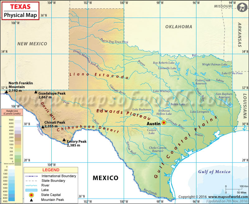
The state of Texas in the southwestern US has four major physical regions:
- Gulf Coastal Plains
- Interior Lowlands
- Great Plains and the Panhandle
- Basin and Range Province
Gulf Coastal Plains
The region is extension of the coastal plain along the Gulf Coast to beyond the Rio Grande. The Balcones Fault and Balcones Escarpment define the interior limit of the region in Texas. These plains are increasingly arid towards west – with mostly prairies and brushlands – while it transforms into pinewoods and hardwoods towards East Texas. Lower Rio Grande Valley, Coastal Prairies, Pine Belt, and Post Oak Belt are sub-regions of Gulf Coastal Plains.
Interior Lowlands
The region stretches from the Blackland Belt in the east to the Caprock Escarpment in the west. From north to south, it lies between the Red River and the Colorado River. West Texas Rolling Plains, Grand Prairie, and the Eastern & Western Cross Timbers are sub-regions of Interior Lowlands. Except the city of Dallas and Fort Worth, the region is mostly rural and its economy depends on agriculture.
The Great Plains
The region itself is a sub-region of The Great Plains of North America. It is further classified into the Llano Estacado, the Panhandle, Edwards Plateau, and the Hill Country. Texas Panhandle comprises northernmost region (26 counties) of the state. Primarily made of limestone, Edwards Plateau covers 40 counties in west-central Texas. Featuring relatively steep slopes, the Hill Country region includes 25 counties south of the mineral-rich Llano Basin.
Basin and Range Province
The region is located west of the Pecos River and north of the Rio Grande. The Chihuahuan Desert, Guadalupe Range, Davis Mountains, and Big Bend are its sub-regions. The Trans-Pecos region features desert valleys, grasslands, and sand hills. It is the most arid and the only mountainous region in the state of Texas. Guadalupe Peak (2,667m), El Capitan (2,458m), and Mount Livermore (2,554m) are some of the tallest mountains in Texas.
 Wall Maps