1.8K
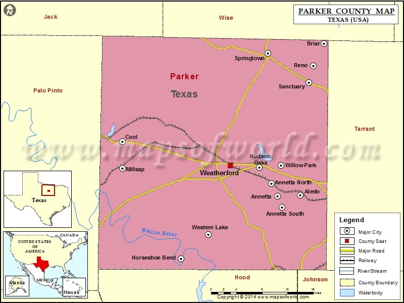
Check this Texas County Map to locate all the state’s counties in Texas Map.
Mountain Peaks in Parker County
| Mountain Peak/Hill | Elevation [Meter] |
|---|---|
| Bald Knob | 359 |
| Buck Knob | 345 |
| Burton Knob | 278 |
| Buzzard Hill | 337 |
| Chattanooga Hill | 330 |
| Duke Mountain | 293 |
| Indian Knob | 387 |
| Joe Bell Mountain | 324 |
| Nebo Mountain | 316 |
| Oyster Hill | 351 |
| Potato Hill | 279 |
| Skeen Peak | 373 |
| Slipdown Mountain | 415 |
| Tater Hill | 343 |
| Tater Nob | 344 |
Airports in Parker County
| Airport Name |
|---|
| A M I G O For Christ Airport |
| Arnett Landing Airport |
| Beggs Ranch/Aledo/ Airport |
| Blo Airport |
| Blue Skies Airport |
| Boe-Wrinkle Airport |
| Bourland Field |
| Buckmaster Heliport |
| Clear Fork Ranch Heliport |
| Cross Wind Airport |
| Driftwood Ranch Airport |
| Eagle Airport |
| Flying E Ranch Airport |
| Flying K Airport |
| Green Ranch Airport |
| Horseshoe Bend Airport |
| Jamak Fabrication Heliport |
| Kezer Air Ranch Airport |
| Log Cabin Airport |
| Mineral Wells Airport |
| Motown Airport |
| Parker County Airport |
| Post Oak Airfield |
| Reb Folbre’s Place Airport |
| Rock Creek Ranch Airport |
| Sam Little International Airport |
| Staggs Heliport |
| Stark Field |
| Tailspin Estates Airport |
| Trinity Meadows Race Track Heliport |
| Weatherford Regional Medical Center Heliport |
| Windy Tales Airport |
Cities in Parker County
| City | Population | Latitude | Longitude |
|---|---|---|---|
| Aledo city | 2716 | 32.697366 | -97.606983 |
| Annetta North town | 518 | 32.720283 | -97.676925 |
| Annetta South town | 526 | 32.674221 | -97.648201 |
| Annetta town | 1288 | 32.695675 | -97.659115 |
| Briar | 5665 | 32.988463 | -97.552835 |
| Cool city | 157 | 32.80007 | -98.011264 |
| Horseshoe Bend | 789 | 32.575236 | -97.878238 |
| Hudson Oaks city | 1662 | 32.750308 | -97.699789 |
| Millsap town | 403 | 32.749251 | -98.011653 |
| Reno city | 2494 | 32.945175 | -97.576977 |
| Sanctuary town | 329 | 32.913158 | -97.58767 |
| Springtown city | 2658 | 32.969577 | -97.68076 |
| Weatherford city | 25250 | 32.75495 | -97.765919 |
| Western Lake | 1525 | 32.621519 | -97.816034 |
| Willow Park city | 3982 | 32.75522 | -97.649863 |
Golf Courses in Parker County
| Name of Golf Course | Latitude | Longitude |
|---|---|---|
| Canyon West Golf Club-Weatherford | 32.70723 | -97.906892 |
| Cross Timbers Golf Course-Azle | 32.885318 | -97.565984 |
| Horseshoe Bend Country Club-Weatherford | 32.577064 | -97.879253 |
| Split Rail Links and Golf Club-Aledo | 32.692336 | -97.647337 |
| Squaw Creek Golf Club-Weatherford | 32.752016 | -97.636921 |
| Sugar Tree Golf & Country Club-Lipan | 32.60979 | -97.926238 |
| The Golf Club At Crown Valley-Weatherford | 32.766196 | -97.676571 |
 Wall Maps